Quick Response Report #114
EFFECTIVENESS OF GEOGRAPHIC INFORMATION SYSTEMS (GIS) APPLICATIONS IN FLOOD MANAGEMENT DURING AND AFTER HURRICANE FRAN
Ute J. Dymon
Department of Geography
Kent State University
Kent, Ohio 44242-0001
1999
 Return to Hazards Center Home Page
Return to Quick Response Paper Index
This material is based upon work supported by the National Science
Foundation under Grant No. CMS-9632458.
Any opinions, findings, and conclusions or recommendations expressed in
this material are those of the author(s) and do not necessarily reflect
the views of the National Science Foundation.
EFFECTIVENESS OF GEOGRAPHIC INFORMATION SYSTEMS (GIS) APPLICATIONS IN FLOOD MANAGEMENT DURING AND AFTER HURRICANE FRAN
ABSTRACT
Geographic Information Systems (GIS) are powerful tools for
eliminating guesswork when it comes to decision making processes during
and after a disaster. This research addresses the GIS support for mapping
and graphic aids for decision makers after Hurricane Fran in North
Carolina. Before the storm, GIS models were applied to calculate the size
of the potential storm surge for several categories of hurricanes,
particularly the storm surge heights expected according to the speed of
the storm. Emergency managers used these models to make decisions about
potential flooding and identified which portions of the population needed
to evacuate given areas. Other GIS applications verified the legitimacy of
insurance claims submitted by those enrolled in the National Flood
Insurance Program (NFIP). Differing degrees of GIS implementation existed
in the local, state and federal operations. Data sharing commonly occurred
between all levels of government. Heretofore, the implementation of GIS
support during major disasters has proceeded slowly. During and after
Fran, at both the federal and state levels, especially, an organized
effort made immediate implementation of GIS possible. Hurricane Fran
established the major advantages GIS has to offer in a disaster management operation.
INTRODUCTION
On September 5, 1996, Hurricane Fran swept across North Carolina
leaving behind a swath of destruction throughout most of the state. The
Hurricane made landfall near Cape Fear, and the eye of the hurricane moved
directly over the coastal city of Wilmington and continued on to Raleigh,
the capital of North Carolina. Fran strengthened to a category 3 (major)
hurricane by the Saffir-Simpson hurricane scale. Hurricane Fran was the
sixth named storm of the 1996 hurricane season. For eleven hours the storm
thrashed the state with winds clocked at 115 mph on the coast and up to 79
mph at Raleigh, located in the center of the state. As dawn broke, it
became evident that Hurricane Fran was one of the worst storms to hit
North Carolina in decades. The storm surge caused severe coastal flooding
and continuous rainfall added to the problem. More than 10 inches of rain
fell in less than 12 hours. The storm was slow moving, and the intense
rainfall quickly flooded the coastal areas. Lowlands were saturated, and
rivers swelled which eventually severely flooded inland areas as well.
Hurricane Fran claimed twenty-two lives in North Carolina. More than 1 million people were without power and other utilities. President Clinton declared 51 out of 100 counties as federal disaster areas. Tens of thousands of buildings were damaged, and
the economy of the state was left in disarray. Property losses,
agricultural, business and tourist industry losses will add Hurricane Fran
to the list of recent mega-disasters in the United States. The Property
Claims Service Division of the American Insurance Services Group reports
that Fran caused an estimated $1.6 billion in insured property damage to
the United States, which includes $1.275 billion in the state of North
Carolina alone, (NCDC, Internet, June 12, 1997). Estimates are still being
revised upward, but Fran will likely top 4 billion dollars when all costs
are identified.
The rising concerns over the losses from natural disasters and
especially losses from hurricanes, the increasing volume of funds required
for relief of victims, and the limited success of communities in managing
their flood-prone areas require a shift in future efforts which now focus
more on understanding the social and economic ramifications and encourages
more adaptive human responses (White and Haas, 1975; Foster, 1986).
Adaptive responses require knowledge of the existing physical and social
spatial conditions of the geographical area impacted. Geographical
Information Systems (GIS) are the ideal tools to apply in disaster
situations to capture and present existing conditions. However, research
after Hurricane Andrew demonstrated that application of GIS was still not
accepted by many emergency managers (Dymon, 1993). Nearly four years have
passed since Hurricane Andrew, and GIS technology has advanced to be a
household name in many government agencies. This research focused on: 1)
the use of GIS after Hurricane Fran, 2) applications of GIS in the pre-
and post-disaster management of the storm, 3) how data was shared among
different agencies, and 4) the role FEMAOs NFIP maps played in the
response and recovery stages.
ARRIVAL IN NORTH CAROLINA
My graduate assistant, Deborah Scheeler, and I drove to North
Carolina on September 23, 1996. We experienced a major traffic jam on Rt.
70 delaying us for nearly four hours. Later, we learned that we had been
driving along the route to the designated debris dump site for this
disaster. Trucks carrying debris from the Hurricane had the right of away
all along the route causing our delay. Like most field researchers after a
disaster, we had to drive a considerable distance to find a hotel room
(within our budget) for the night. Federal agents and relief workers had
pre-booked available hotels in the region.
INFORMATION GAINED FROM STATE AND FEDERAL WORKERS
North Carolina Center for Geographic Information and Analysis
(CGIA)
Through executive order by the Governor of North Carolina, the
North Carolina Geographic Information Coordination Council (GICC) was
established in 1994. The task was to coordinate a statewide data
initiative. As a result, the State of North Carolina Center for Geographic
Information and Analysis (CGIA) was staffed to support the Council in its
efforts to compile and maintain a corporate geographical database.
Numerous public and private organizations participated in this effort.
Federal content standards or digital geospatial metadata were applied to
assure quality when data was provided from different sources. The CGIA
serves as a clearinghouse for this data. Currently, the CGIA maintains
about 60 data layers, including: USGS basemap files, municipal and county
boundaries, census boundaries, population files, water quality, air
quality, coastal area management act information, land use and land cover,
soils, topography, hydrology/hydrography, hazardous waste facilities,
Hurricane Storm Surge Inundation Areas, National Wetland Inventory,
transportation, water supply and historical sites (North Carolina
Geographic Data Catalog, 1996).
Application of GIS Before, During and After Fran
Before Hurricane FranOs arrival in North Carolina on September 5th
and 6th in 1996, the North Carolina Center for Geographic Information and
Analysis prepared Hurricane Storm Surge Inundation Area maps. These maps
showed the historic extent of hurricane storm surge inundation for four
southeastern coastal counties in North Carolina. The application of a
computer program called the Sea, Lake and Overland Surges from Hurricane
(SLOSH) Model was used to produce maps to show the potential flooding for
both fast and slow velocity hurricanes. The maps showed land susceptible
to flood inundation according to the severity of different hurricane
categories. The inundation information was overlaid on a 1:24,000 United
States Geological Survey, 7.5 minute Series Quadrangle. This provided
basic information about the areas such as roads and topography and basic
land use. These maps proved to be very useful and were the basis for the
preparation of evacuation maps.
With the use of the SLOSH model, Hurricane Evacuation Restudy maps
were prepared. These maps showed storm surge heights in feet above
National Geodetic Vertical Datum. They were prepared for slow and fast
moving hurricanes of categories 2, 3 and 5 since the same evacuation maps
are used for category 4 and 5 hurricanes. These Hurricane Evacuation
Restudy maps were applied to analyze the risk for flooding. Emergency
managers employed the maps to guide the evacuation of residents in the
stateOs coastal and lowland areas. The Federal Emergency Management Agency
(FEMA) quickly identified the valuable data layers available at North
Carolina's CGIA. Before Hurricane Fran even arrived, FEMA requested data
on hurricane storm surge inundation areas, state-owned complexes,
historical sites and districts, and natural heritage element occurrence
sites and sought county road maps with municipal boundaries. FEMA worked
closely with the CGIA in preparation for this storm. All computer files
gathered for GIS applications were carefully backed up before the storm
arrived.
The Division of Forest Resources requested maps of forest damage.
These maps were created by overlaying various forest cover layers with the
hurricane storm surge inundation data. A map of the declared disaster
counties and the path of the storm was requested by the Geographic
Information Coordination Council, and this map was prepared after the
storm by the CGIA (Figure 1). County-wide basemaps were requested for
various agencies, including the Department of Environment, the American
Red Cross, Health and Natural Resources. The latter used the maps for the
planning of mosquito spraying. Data were provided in ARC/INFO, ArcView,
MapInfo and Atlas GIS formats in order for federal agencies to work with
the data immediately (State of North Carolina, 1996).
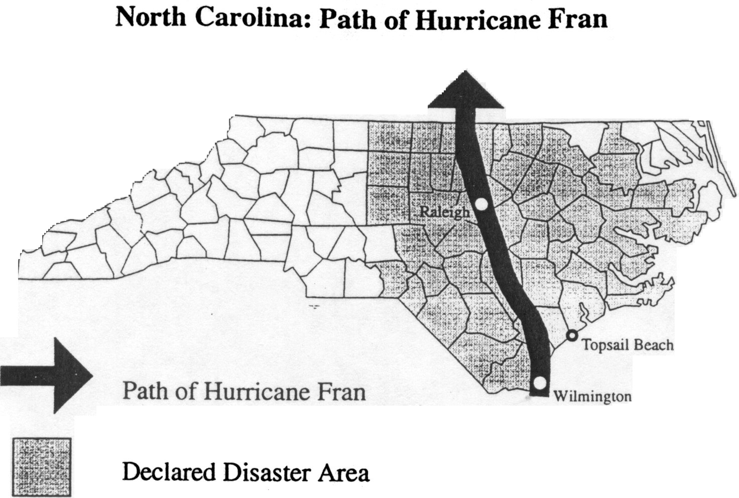 Figure 1: Location Map
GIS Technology in the Disaster Field Office
In contrast to previous hurricanes, such as Hurricane Andrew, most
federal agencies brought their own GIS to operate in the Disaster Field
Office in Raleigh or were directly connected through the World Wide Web
(WWW) or through the Internet with their home offices. Situation reports
were released daily over the WWW to keep politicians, such as the Governor
and cabinet members as well as emergency managers, abreast of the changing
situation in the field (FEMA WWW, September 1996).
Weather conditions, the physical conditions, such as debris
removal, social impacts, and cultural impacts, were monitored, and reports
on these subjects were sent out over the WWW. In addition, requests for
supplies, equipment, and volunteers were broadcast over the WWW to the
population at large. Field data were available within a few hours, not
only to emergency responders on the ground, but also to the emergency
community at large on the Internet. This was a decided contrast compared
to information flow after previous natural disasters such as Hurricanes
Hugo and Andrew. FEMA had also greatly speeded up its process of
identifying those who qualified for disaster assistance. Within just a
week, some victims received checks for repairs needed to their properties.
Clearly, information technology has found its way into disaster management
operations and has taken much guesswork out of the response process for
emergency decision makers.
The National Flood Insurance Program (NFIP)
Congress passed the National Flood Insurance Act of 1968 and
established the National Flood Insurance Program (NFIP) in response to
mounting flood losses and disaster relief costs. The public could purchase
insurance from the fund if their own local governments implemented and
enforced measures to reduce flooding risk in new construction (FEMA,
1995). To set appropriate premium rates, Congress authorized the
systematic identification of flood-risk areas across the nation. FEMA's
Mitigation Directorate is in charge of creating and updating flood maps
which are called Flood Insurance Rate Maps (FIRMs). These maps identify a
variety of information, including common physical features, such as major
highways, secondary roads, railroads, lakes, streams and other waterways.
In addition, the risk factor of flooding in local communities is mapped
(FEMA, 1995). The most significant risk factors are flood zone and
elevation differences such as 100- and 500-year flood hazard areas. In
recent years these maps have been made available in digital format
becoming Digital Flood Insurance Rate Maps (DFIRMs).
The purpose of these maps is to identify special flood hazard
areas, identify the location of specific properties located within these
flood hazard areas, identify the base 100- or 500- year flood elevation at
a specific site, locate regular floodways and identify the potential
magnitude of a given flood. After Hurricane Fran, these maps were used to
match addresses with flood insurance policies.
As Fran pounded the state, there were about 67,331 National Flood
Insurance policies in place in North Carolina, mostly along the coast,
representing $7.5 billion in coverage. FEMA awards disaster grants to the
States for subgranting to individuals and to local governments. The task
is to match the DFIRMs to the addresses of people requesting funding for
repairs to determine the eligibility of those applying for NFIP funds.
FEMA hired consulting firms to deal with this matching task. These private
firms developed a database of georeferenced addresses for application in
GIS; communities can now purchase this database for their own use. Over
$100.9 million has been paid by the NFIP in North Carolina as a result of
Hurricane Fran (FEMA, Internet March 5, 1997).
INTERVIEWS WITH VICTIMS
Upon our return to Kent State University, we interviewed eleven
victims by phone. Each person interviewed owned a home or trailer. The
victims came from three locations, Topsail Island, Surf City and Kure
Beach. Victims were eager to share their experiences with us. An
overwhelming majority of these victims were natives of North Carolina.
All of the victims we talked to took the National Weather Service warnings
about the approaching hurricane seriously and had evacuated before the
storm made landfall. Most of the victims stayed with friends or relative
within a 50 mile radius of their homes. However, four persons stayed in
shelters in Wilmington, N.C. Each of the victims experienced severe
property damage. Two lost their homes, and two lost trailers. The rest of
the interviewees experienced major property damage. Three persons had
previously experienced property damage after Hurricane Bertha made
landfall on the eve of July 12, 1996. When Fran made landfall, none of the
three had their Bertha damages completely repaired yet. All except two of
the eleven victims participated in the NFIP. This small sample of NFIP participants helps characterize somewhat the incidence of repetitive losses in the hurricane-prone lands of North Carolina.
THE INFORMATION AGE ENCOMPASSES FRAN
Through this research an attempt was made to try to identify the
extent to which GIS were applied before, during and after Hurricane Fran
by emergency managers. On the local level, GIS was not, or was only
scarcely, applied at the early stages of response. Local communities were
so hard hit physically that they were without power, in some cases for
several weeks. Local offices were closed or had to respond to more urgent
problems after the storm.
At the state level, the data layers provided by North Carolina's
CGIA were without question of major importance in the management of this
disaster and will be especially valuable in the future for mitigation
decisions. This availability of detailed data gathered before the extreme
event occurred constituted a major difference between disaster information
flow after Hurricane Andrew in 1992 (Winter, 1997) and Hurricane Fran in
1996.
It was clear that, in the four years since Hurricane Andrew, all
federal agencies identified in this investigation of Hurricane FranOs
effects had reached the Information Age. With GIS available, they took an
active role in fast and efficient dissemination of field information. This
speedy information flow was the most outstanding characteristic of the
management of disaster conditions after Hurricane Fran.
THE NEED TO APPLY GIS IN FUTURE DISASTERS
Many federal employees predicted that Fran will provide the
impetus for additional GIS applications within their agencies. With the
dramatic rise in disaster costs, all possible forms of technological
advances must be explored on a continuing basis at all three levels of
government in order for disaster response to become as efficient as
possible.
REFERENCES
Dymon, Ute J., 1993. Map Use During and After Hurricane Andrew,
Final Report to the Natural Hazards Research and Applications Information
Center, Boulder, Co., 1-10.
Federal Emergency Management Agency (FEMA). 1995. Audit of the Accuracy
of Flood Zone Ratings. 3-8.
FEMA, 1995, Audit of the Enforcement of Flood Insurance Purchase
Requirements for Disaster Aid Recipients. 1-5.
FEMA, 1996. World Wide Web, September 1996.
Foster, H.D., 1996. Disaster Planning: A Synopsis. Interdisciplinary
Science Reviews, 11:359-376.
National Climate Data Center. 1996 Atlantic Tropical Storms: Views from
NOAA Satellites. June 12, 1997. Online. Internet. Sept 10, 1997.
Available:
ncdc.noaa.gov/publications/techrpt/tr9702/tr9702.
State of North Carolina, 1996. North Carolina Geographic Data
Catalog. Raleigh, NC: Center for Geographic Information and Analysis.
_____, 1996. Corporate Geographic Database Digital Data Layer
Listing. Raleigh, NC: Center for Geographic Information and Analysis.
White G. and J.L. Hass, 1975. Assessment of Research on Natural Hazards,
MIT Press, Cambridge, MA.
Winter, Nancy L., 1997. Damage Assessment Mapping in the Aftermath of
Hurricane Andrew. 18th ICA/ACI International Cartographic Conference,
Stockholm, Sweden, Vol.3, pp. 1228-1235.
ACKNOWLEDGMENTS
This research was funded by a Quick Response grant from the
Natural Hazards Research and Applications Information Center, Boulder
Colorado. The map of Hurricane FranOs path was prepared by Deborah
Scheeler in the Cartographic Laboratory at Kent State University.
Return to Hazards Center Home Page
March 12, 1999
hazctr@colorado.edu