
The April 2004 Tornado in North-Central Bangladesh:
A Case for Introducing Tornado Forecasting and Warning Systems
Bimal Kanti Paul 2004
Department of Geography
Kansas State University
118 Seaton Hall
Manhattan, KS 66506
Rejuan Hossain Bhuiyan
Department of Geography and Environment
University of Dhaka
Dhaka, Bangladesh
A printable version of this QR report is available in PDF format.
This material is based upon work supported by the National Science Foundation. Any opinions, findings, and conclusions or recommendations expressed in this material are those of the author(s) and do not necessarily reflect the views of the National Science Foundation or the Natural Hazards Research and Applications Information Center.Citation: Bimal Kanti Paul and Rejuan Hossain Bhuiyan. 2004. The April 2004 Tornado in North-Central Bangladesh: A Case for Introducing Tornado Forecasting and Warning Systems. Quick Response Research Report 169. Boulder, CO: Natural Hazards Research and Applications Information Center, University of Colorado. http://www.colorado.edu/hazards/qr/qr169/qr169.html.
Summary
As with floods, cyclones, and storm surges, Bangladesh is also vulnerable to tornadoes. Each year this South Asian country experiences more than six tornadoes. On April 14, 2004, a severe tornado swept through 38 villages of north-central Bangladesh, destroying everything in its path, including livestock, houses, crops, trees, and businesses. The human death toll reached 111, while thousands sustained injuries. The purpose of this research project was to gain knowledge from tornado victims regarding the warning they received prior to the tornado on April 14, 2004. Face-to-face interviews with 216 respondents randomly selected for this study revealed that no tornado forecasting and warning system exists in the study area or in Bangladesh in general. All respondents strongly favored the introduction of public tornado forecasting and warning systems in the country. This study briefly outlines how these systems could be implemented.
Acknowledgments
This research was funded by a Quick Response program grant from the Natural Hazards Research and Applications Information Center at the University of Colorado at Boulder. We would like to thank all field investigators, particularly Bipul Kanti Paul and Mati Lal Dhar, for conducting the survey in the study villages. We are also grateful to Andy Hopp for creating Figure 1 for this report.
Introduction
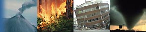
On the evening of April 14, 2004, a devastating tornado swept over 38 villages in two north-central districts (Mymensingh and Netrokona) of Bangladesh, killing at least 111 people, seriously injuring more than 1,500, and completely destroying 3,400 homes (Table 1).1 More than 1,000 injured victims were admitted to hospitals located in the nearby Upazilla and district headquarters.2 According to the Meteorological Department in Dhaka, this tornado formed around 6:30 p.m. near Haluaghat Upazilla in the Mymensingh district, moved in a southeast direction for about 25 miles (37 km), and broke up at 7:30 p.m. near Netrokona Sadar Upazilla in the Netrokona district (Figure 1). This tornado had a speed of 100 miles (150 km) per hour with an average width of about half a mile. It traveled discontinuously, in a skipping manner, over rural areas of north-central Bangladesh, lasting no more than five minutes at any given location.
The tornado of April 14, 2004, was the deadliest since the tornado system of May 13, 1996, that struck central Bangladesh and killed more than 700 people and injured at least 33,000 (see Paul 1998; Schmidlin and Ono 1996). This particular tornado damaged 20 percent of standing crops, uprooted trees and electric poles, and caused serious disruptions in power supplies. The objectives of this study are to explore the nature of formal and/or informal warnings residents of the tornado-impacted villages received prior to the tornado touchdown and how these residents responded when they learned about and/or personally observed the tornado.
Tornadoes in Bangladesh
Bangladesh has a long history of tornado incidents. The first reported tornado in the country occurred in March 1875 (Finch 2004). After a careful review of newspaper reports, Ono (2001) claims that Bangladesh experienced 191 tornadoes between 1967 and 1996.3 This represents an average of 6.4 tornadoes per year. Although he found no linear trend in terms of the number of reported tornadoes over that period, available evidence suggests that the frequency of tornadoes has increased in recent years. According to the Bangladesh Disaster Report, 15 tornadoes occurred in 1998 (see Ahmad and Kabir 2001). From January to November 2004, 33 tornadoes occurred in different parts of the country. Seventeen of these 33 were killer tornadoes, which resulted in 153 deaths between January and November 2004 in Bangladesh.
Although the frequency of tornadoes in Bangladesh is not particularly high relative to the United States, the number of fatalities is. There were 5,373 tornado deaths reported in Bangladesh over the period of 1967-96 (Ono 2001). This translates to about 179 deaths per year; no other country has such a high death toll attributable to tornadic activity. For example, the United States, which experiences more than one thousand tornadoes each year (Boruff et. al. 2003), recorded an average of 65 tornado fatalities per year between 1974 and 2003 (NWS 2004). Clearly, tornadoes in Bangladesh are more deadly than those in the United States. The last tornado to kill more than 100 people in the United States was in 1953 (see Ono 2001). This difference in fatality rates is probably due to the fact that while many efforts have been made in the United States to mitigate the tornado hazard, few such efforts have been implemented in Bangladesh. Thus, death tolls in Bangladesh, from tornadoes, remain high.
Ono (2001) reported that between 1967 and 1996, Bangladesh experienced 114 tornadoes that involved loss of human life. These tornadoes accounted for about 60 percent of all tornadoes reported. This rate is much higher than in the United States (3.2 percent) (see Grazulis 1991). Ono (2001) provided three potential explanations for a higher percentage of tornado fatalities in Bangladesh: (1) tornadoes in Bangladesh are so violent that most of them result in fatalities, (2) poorly constructed housing common throughout Bangladesh increases the deaths, and (3) there are many tornadoes occurring in Bangladesh that remain unreported. The high population density, a paucity of preparedness programsincluding tornado forecasting and warning systemsand tin houses built on elevated ground are also associated with the high incidence of tornado-related deaths in Bangladesh. Tornadoes dismantle tin sheets like paper, turning them into airborne missiles that can cause injury and death.
Since gaining independence in 1971, Bangladesh has experienced eight major tornadoes, each killing more than 100 people (Table 2). Of these eight tornadoes, the most devastating one occurred on May 26, 1989, in Saturia (27 miles/40 km northwest of Dhaka). This tornado killed between 800 and 1,300 people (Grazulis 1991). It is believed that this particular tornado was the worlds deadliest tornado in terms of lives lost (Schmidlin and Ono 1996). Almost all of these major tornadoes occurred between late-March and mid-May. When all of the tornadoes that occurred between 1967 and 1996 are considered, Ono (2001) claims that the average number of tornadoes for the month of April is the highest (65 tornadoes, 36 percent).4 May has the second highest average with 40 tornadoes (22 percent), followed by March with an average of 14 tornadoes (8 percent). Tornadoes occurred during every month except December, and most of the tornadoes occurred in a relatively small area of central, south-central, and southeast Bangladesh.
According to Ono (2001), central Bangladesh has a higher frequency of tornadoes than other regions of the country (Figure 2) (also see Ahmad and Kabir 2001). Between 1967 and 1996, the average number of tornadoes that occurred annually per 10,000 square miles in the six districts of central Bangladesh was 3.19, the highest number in Bangladesh and comparable to the average in Ohio, South Dakota, Wisconsin, and Georgia (Grazulis 1991).5 Outside central Bangladesh, tornado frequency is generally between 0.5 and 1.5 per 10,000 square miles. Three districts in Bangladesh had no reported tornadoes between 1967 and 1996 period (Figure 2). Two of these are coastal districts and the other one is a hilly district. The nations tornado frequency is 1.12 per 10,000 square miles. Although not a very high value, this figure does indicate that tornadoes are a common weather phenomenon in Bangladesh.
In spite of the long history and high mortalities involved, tornadoes have received little attention from hazards researchers in Bangladesh. According to Schmidlin and Ono (1996), the first serious attempt to study tornadoes in Bangladesh was by Peterson and Mehta (1981) who analyzed the physical characteristics of 51 tornadic events that occurred in India and Bangladesh since 1835. Schmidlin and Ono (1996) examined reasons for the 605 deaths that resulted from tornadic activity on May 13, 1996, in the districts of Jamalpur and Tangail in Bangladesh. They concluded that high population density, tin building materials, poor medical facilities, slow transportation, a fatalistic public attitude toward nature, and a weak style of home building were significant risk factors for the tornado fatalities experienced in May of 1996. These researchers also mentioned that a high frequency of tornado occurrence with no warning systems and/or preparedness programs expose people to high risk.
The May 1996 Jamalpur and Tangail tornado was also studied by Paul (1997) who examined how the tornado victims in Tangail adjusted to the destruction. He identified the sources and extent of support received by the victims. Like Schmidlin and Onos (1996) study, Pauls study was funded through the Quick Response program at the Natural Hazards Research and Applications Information Center at the University of Colorado at Boulder.
In his 2001 study, Ono (2001) proposed a practical and effective strategy to reduce tornado fatalities in Bangladesh. He designed a household tornado shelter and explored the possibility of its adoption by Bangladeshi citizens. Surveys were conducted to ascertain the suitability of the designed shelter for rural Bangladeshis. The results of these surveys indicated interest in installing shelters, provided financial assistance is made available. Ono (2001) also recommended introducing other mitigation measures, such as tornado forecasting, which can help reduce the number of fatalities and injuries, as well as lessen damage and suffering from future tornadoes in Bangladesh.
Methodology
The research underlying this study made use of both primary and secondary data. Primary data collection was based on fieldwork performed in tornado-impacted villages of the Mymensingh and Netrokona districts. Secondary sources included a wide range of salient documents and reports. The primary technique used to generate and collect information during the fieldwork was interviewing tornado victims through a structured questionnaire. A total of 216 tornado victims from six villages of Haluaghat and Netrokona Sadar Upazillas were randomly selected and successfully interviewed (Figure 1). The initial plan was to interview 300 victims from all 38 tornado-affected villages, but this plan had to be abandoned because the tornado-impacted districts, particularly Netrokona, were experiencing severe flooding at the time the fieldwork was conducted. This fieldwork was carried out during the first week of August 2004.
Data collected through the questionnaire were supplemented by information gathered through informal discussions with village leaders, local government officials, and officials of nongovernmental organizations (NGOs). Information related to tornadoes in Bangladesh in general and the tornadoes in Mymensingh and Netrokona on April 14, 2004, in particular, was collected from the Bangladesh Meteorological Department (BMD), Disaster Management Bureau of the Ministry of Disaster Relief, Space and Atmospheric Research Center (SPARRSO), and the Bangladesh Red Crescent Society. Offices of these organizations are located in Dhaka, the capital of Bangladesh.
Inquiries were made regarding existing as well as future tornado preparedness programs and plans by the national government to both forecast and warn people of tornado hazards. An extensive Internet search focusing on the tornadoes in Mymensingh and Netrokona districts on April 14, 2004, also proved very insightful. Seven field investigators were involved with data collection from both primary and secondary sources. All of these field investigators had previously worked with research projects similar to the present study.
Respondent Characteristics
As noted, there were 216 respondents to the survey administered in the selected tornado-impacted villages. The majority of the respondents were male (84 percent), which is probably a result of social customs of the study area (Table 3). Social norms do not always allow women, particularly Muslim women, to talk with an unknown male. The seven field investigators were not locally recruited and none were women. Further, time constraints and the flood situation restricted recruitment of local, and/or female investigators. Slightly over 93 percent of the respondents were married at the time of the survey (Table 3).
Nearly half of the respondents were between the ages of 30 and 44; only about 13 percent of the respondents were under the age of 30 (Table 3). Nearly 64 percent of the respondents were employed in farming at the time of the survey and about 40 percent were illiterate. Both of these figures are consistent with national rates. In addition to farming and business, the additional category entitled others is included under occupation. This occupational category includes people employed in the service sector, laborers, housewives, students, carpenters, and fishermen (Table 3). Slightly over half of the respondents earned between 30,000 and 60,000 Taka (US$500 and $1,000) per year. All the socioeconomic characteristics of the respondents surveyed suggest that they represent a cross-section of the nation to a great extent.
Results
Survey data revealed that all 216 respondents experienced damage from the tornado on April 14, 2004. This tornado either partially or completely destroyed their homes and/or business establishments. It also broke or uprooted most trees, and caused extensive damage to field crops. Respondents who raised cattle, goats/sheep, and chicken and ducks reported losses of one or more animal; more than 1,000 cattle were killed by this tornado. Bangladeshis usually keep domestic animals as an additional source of income. In monetary terms, respondent households experienced an average loss of 60,000 Taka (US$1,000).
Forty-five (21 percent) of the 216 respondents reported at least one death of a family member due to the tornado on April 14, 2004. Most deaths were caused by flying debris and collapsed houses. Slightly over 85 percent of all respondents reported tornado-related injuries in their households. The number of persons injured in respondent households ranged from 1 to 15, with an average of 3.25 injuries per household. Most of these injuries were severe and required immediate medical attention. Nearly half of those injured had to be admitted to hospitals in Mymensingh, Netrokona, and Haluaghat. The most severely injured had to be transported to Mymensingh Medical College Hospital. There was a public appeal in the town of Mymensingh for the donation of blood.
Many people from nearby villages and the local authorities took part in the rescue operation and hospitalization of the injured immediately after the tornado. According to a ReliefWeb information bulletin (2004), hospitals were inundated by tornado victims seeking treatment for injuries. Some hospital beds were holding up to three or four patients at a time, while many more victims were treated in corridors, on mats. At least six critically injured tornado victims died in a hospital. Later, the border security force, called the Bangladesh Rifles, police, and the national armed forces started rescue operations in the affected areas. Because so many people were injured, the Bangladesh government and NGOs established emergency medical camps to provide necessary support to tornado victims. Trauma counseling was provided by several NGOs.
Before the tornado on April 14, 2004, none of the 216 respondents surveyed had experienced a tornado. Respondents acknowledged that strong winds are not unusual at that time of the year in the area, but they had never confronted such strong winds in the past. Although Bangladesh experiences tornado fatalities every year, no formal tornado forecast and/or warning system exists in the country. For this reason, it was expected that people in north-central Bangladesh had developed their own ways of predicting the occurrence of a tornado, disseminating warnings, and taking action after becoming aware of a tornado threat. This expectation proved to be wrong, probably because most residents of the area that was impacted by the tornado on April 14, 2004, had never experienced such an event before.
Since the tornado on April 14, 2004, coincided with the celebration of the Bengali New Years Day, and it occurred in the evening, nearly 90 percent of all respondents were at home during the tornado, and the remaining respondents were either at work, away from home, or returning home. After hearing a roar from the northwest, almost all respondents indicated they were scared and thought a severe windstorm was approaching. Those respondents who were at home looked for other members of their families and immediately sought shelter inside their houses. This is an understandable reaction during a storm threat. Most of the respondents who went into a house took shelter under wooden beds. They stayed inside until the sound of the tornado stopped. By that time, many realized that they had just experienced a tornado for the first time in their lives.
Since there was no tornado forecasting and warning, respondents were asked whether they were in favor of establishing a public tornado warning system to warn citizens of approaching tornadoes. Although all of the respondents answered this question affirmatively, they also stressed the need for construction of household and/or public tornado shelters along with tornado forecasting and warning systems. This is consistent with the findings of Ono (2001) who studied the willingness of 200 residents of tornado-prone areas of Bangladesh to adopt household tornado shelters. All of those who responded indicated that they were in favor of installing such a shelter in their homestead compound. However, most also indicated that they were not willing to pay the full cost, but were willing to build household shelters with financial support from the government and/or NGOs.6
Conclusions and Recommendations
The purpose of this research project was to understand the nature of the tornado warning received by victims of the tornado on April 14, 2004, that demolished 38 villages in north-central Bangladesh. Despite the occurrence of several killer tornadoes each year, Bangladesh has not yet made any effort to mitigate tornado hazards. Given the frequency and devastating nature of tornadoes, the virtual absence of tornado warning systems, and the overwhelming support of tornado victims in favor of such systems, this study recommends the introduction of tornado forecasting and warning systems and the establishment of a communications network to warn citizens of approaching tornadoes. Considering financial constraints, the initial introduction of tornado forecasting and warning systems should be targeted to the most tornado-prone districts of Bangladesh (see Figure 2). As a first step to introducing these warning systems, there is a need to establish more weather stations. Currently, Bangladesh has only 28 weather stations, a number far inadequate for a country with an area of about 56,000 square miles (144,000 square km) and a population of 135 million.
Further, all weather stations in the most tornado-prone districts should be equipped with Doppler Radar, which would facilitate accurate forecasting of tornadoes. Donor and international aid agencies, such as the World Meteorological Organization, the U.S. Agency for International Development, and other U.S. agencies (e.g., the National Severe Storms Laboratory and the National Weather Service) may help Bangladesh technically and financially to purchase Doppler Radar and train local forecasters to manipulate and maintain the new equipment.
The introduction of Doppler Radar should be followed by the establishment of tornado warning systems. After receiving a tornado forecast from a regional weather station or another source (e.g., SPARRSO), the BMD, located in Dhaka, should issue tornado watches and warnings to concerned people through mass media (radio and TV) and through the highest ranking government officials stationed in district and Upazilla headquarters (Figure 3). The BMD should contact the district commissioner (DC) of the concerned district regarding the distribution of tornado watches and warnings.7 The DC should inform the Upazilla administrator, called Upazilla Nirbahi officer (UNO), the UNO, in turn, should inform the chairman of the concerned unions.8
Using union law enforcement personnel (locally called chowkidars and dafadars), the chairman could then warn people in the union. Emergency personnel could go door-to-door or announce the impending danger through megaphones and microphones. At the same time, the union chairman could take advantage of public speakers at mosques to warn people of approaching tornadoes. Mosques are ubiquitous in rural Bangladesh and in Hindu-dominated areas. Temples could be used to serve the same purpose. In order to quickly disseminate tornado warnings, BMD officials could bypass the DC and contact the Upazilla administrator directly (Figure 2). Government officials at the district and Upazilla levels and the union chairman could be contacted via regular or cellular telephones. Telephones are available in all Upazillas of Bangladesh and cellular phones are becoming very popular both in cities and in rural areas as well. In 2002, there were 13.2 fixed lines and mobile telephones per 1,000 people in Bangladesh. This ratio was close to one in 1990 (see World Bank 2004).
As with telephones, radio and televisions are ubiquitous in Bangladesh. While all radio stations are operated by the government, television stations are both privately and publicly owned. There are at least 30 radio and more than two dozen television stations operating in Bangladesh. Most of the television stations broadcast programs twenty-four hours a day, seven days a week, and most radio stations operate for most of the day and/or night. These sources could easily be utilized to broadcast tornado watches and warnings to the people. Ownership of both radios and televisions has increased manyfold during the last two decades.
It is worthwhile to mention that hazard warnings are viewed as more effective when delivered by members of a local community than when delivered by mass media (see Quarantelli 1984). Hazard literature also claims that public compliance with warnings is high when the warnings come from more than one source. Moreover, warnings via mass media are most likely to be believed if issued by authentic government sources (see Balluz et al. 2000; Haque 1995). Therefore tornado warning should be delivered in Bangladesh using both mass media and local law enforcement personnel.
After the tornado forecasting, early warning, and communication networks are well established, the Bangladesh government could introduce weather radios and establish tornado sirens in rural areas. More modern forecasting and warning technologies currently are in use in the United States and these could also be introduced in Bangladesh (see Golden and Adams 2000).
It is worth noting that cyclone warning systems were in existence in Bangladesh before its independence in 1971. Following the November 1970 cataclysmic cyclone, which killed half a million people in Bangladesh and damaged properties worth $US63 million, the Bangladesh government supported by the Red Cross and Red Crescent initiated the Cyclone Preparedness Program (CPP). It aims to undertake effective cyclone preparedness measures in the coastal area in an attempt to save and mitigate the loss of more than 80 million people (see Haque 1995). The CPP has more than 20,000 trained volunteers, who disseminate cyclone warning signals, assist people in the evacuation process, execute rescue operations, and provide first aid and help in distributing relief goods. In the 1990s alone, the CPP successfully evacuated 2.5 million people into emergency shelters before cyclones hitand very probably saved their lives as result (IFRC and RCS 2002).
The Bangladesh government also established a Flood Forecasting and Warning Center in 1972 under the administrative control of the Bangladesh Water Development Board to aid national preparedness for floods (see Chowdhury 2000). Both the flood and cyclone warning systems have improved in Bangladesh over time, but it is not clear why the government has not yet introduced tornado forecasting and warning systems. There is no doubt that such systems can reduce loss of life and human suffering significantly.
As indicated earlier, adequate warning is not effective if people at risk have no access to a tornado shelter. Along with establishment of a tornado warning system, there is a need for the construction of shelters in which people can take refuge subsequent to a tornado warning. Structurally, most houses in rural areas are weak and are often built on elevated ground. These houses, particularly those that use corrugated tin as roofing and/or wall material, are considered the highest risk factor associated with tornado-related deaths (Ono 2001). Tin sheets from such structures become airborne missiles during a tornado and can cause injury and death. Ono (2001) recommends restricted use of tin as a building material in Bangladesh. People should also be encouraged to construct household tornado shelters. However, because all people will not be able to build such a shelter, the government should install public tornado shelters in rural areas. Such structures could be installed in public spaces such as schools, hospitals, and markets. Finally, tornado-warning systems should be integrated into disaster preparedness and management programs rather than exist in isolation.
Notes
- A district is the second largest administrative unit in Bangladesh with a population of two million or more.
- Upazilla is the lowest administrative unit in Bangladesh. It comprises several unions. A union, in turn, comprises 20-30 villages.
- The number of reported tornadoes in Bangladesh is representative of a stage of under-reporting similar to that in the United States before 1950 (see Ono 2001).
- Approximately 90 percent of all tornado deaths are reported in April (see Ono 2001).
- These six districts are members of the greater or old Dhaka district, meaning they were under the Dhaka district prior to administration reform in the 1980s. Through this reform, new districts were created by breaking up the old ones and the number of districts, thus, increased from 20 to 64. The map uses 20 areal units representing all old districts of Bangladesh.
- For more details see Ono (2001).
- A DC is the top ranking government officer at the district level.
- A union chairman is elected by popular votes.
References
Ahmad, N., and Kabir, S.A. 2001. Tornadoes in Bangladesh. In Disaster in Bangladesh: Selected Readings, K. Nizamuddin (ed.), pp.137-145. Dhaka: DRTMC, University of Dhaka.
Balluz, L. et al. 2000. Predictors for Peoples Response to a Tornado Warning: Arkansas, 1 March 1997. Disasters, 24:71-77.
Boruff, B.J. 2003. Tornado Hazards in the United States. Climate Research, 24:103-117.
Chowdhury, M.R. 2000. An Assessment of Flood Forecasting in Bangladesh: The Experience of the 1998 Flood. Natural Hazards, 22:139-163.
Finch, J.D. 2000. Bangladesh and East India Tornadoes: Background and Information. http://bangladeshtornadoes.org/bengaltornadoes.html (accessed on May 4, 2004).
Golden, J.H., and C.R. Adams. 2000. The Tornado Problem: Forecast, Warning, and Response. Natural Hazards Review, 1:107-118.
Grazulis, T.P. 1991. Significant Tornadoes, 1880-1989, Vol. 1: Discussion and Analysis. St. Johnsbury, VT: Environmental Films.
Haque, C.E. 1995. Climatic Hazards Warning Process in Bangladesh: Experience of, and Lessons from, the 1991 April Cyclone. Environmental Management, 19: 719-734.
IFRC (International Federation of Red Cross) and RCS (Red Crescent Societies). 2002. World Disasters Report. Geneva: IFRC and RCS.
NWS (National Weather Service). 2004. Weather Fatalities. http://www.nws.noaa.gov/om/hazstats.shtml (accessed on October 25, 2004).
Ono, Y. 2001. Design and Adoption of Household Tornado Shelters to Mitigate the Tornado Hazard in Bangladesh. An unpublished Ph.D. Dissertation, Kent State University, Kent, Ohio.
Paul, B.K. 1998. Coping with the 1996 Tornado in Tangail, Bangladesh: An Analysis of Field Data. The Professional Geographer, 50:287-301.
Paul, B.K. 1997. Survival Mechanisms to Cope with the 1996 Tornado in Tangail, Bangladesh: A Case Study. NHRAIC, University of Colorado, Boulder, CO. QR92.
Peterson, R.E., and Mehta, K.C. 1981. Climatology of Tornadoes of India and Bangladesh. Arch. Meteor. Geophysik, Bioklim, 29B:345-356.
Quarantelli, E.L. 1984. Perceptions and Reactions to Emergency Warnings of Sudden Hazards. Ekistics, 51:511-515.
ReliefWeb. 2004. Bangladesh: Tornado Information Bulletin No. 2/2004. September 16, 2004.
Schmidlin, T., and Ono, Y. 1996. Tornadoes in the Districts of Jamalpur and Tangail in Bangladesh. NHRAIC, University of Colorado, Boulder, CO. QR90.
World Bank. 2004. Bangladesh. http://www.worldbank.org/countries/ (accessed on October 25, 2004).
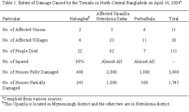
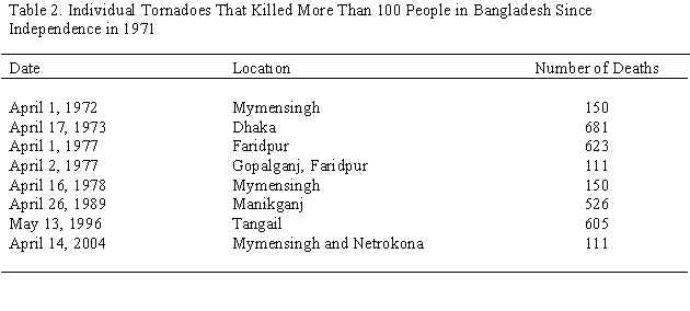
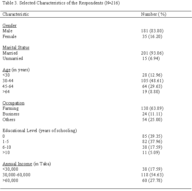
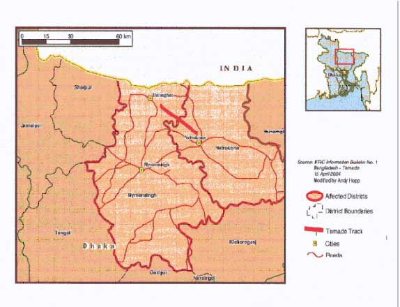
Figure 1: The path of the tornado in north-central Bangladesh on April 14, 2004.
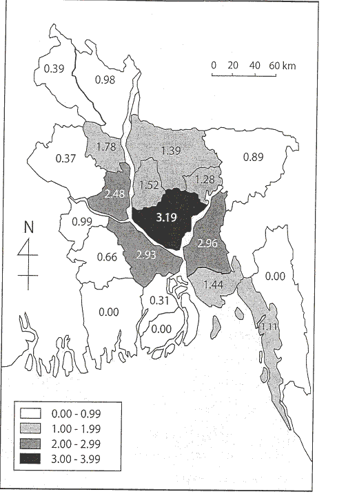
Figure 2: The distribution of the average tornado occurrence per 10,000 square miles in Bangladesh between 1967 and 1996.
Source: Ono (2001).
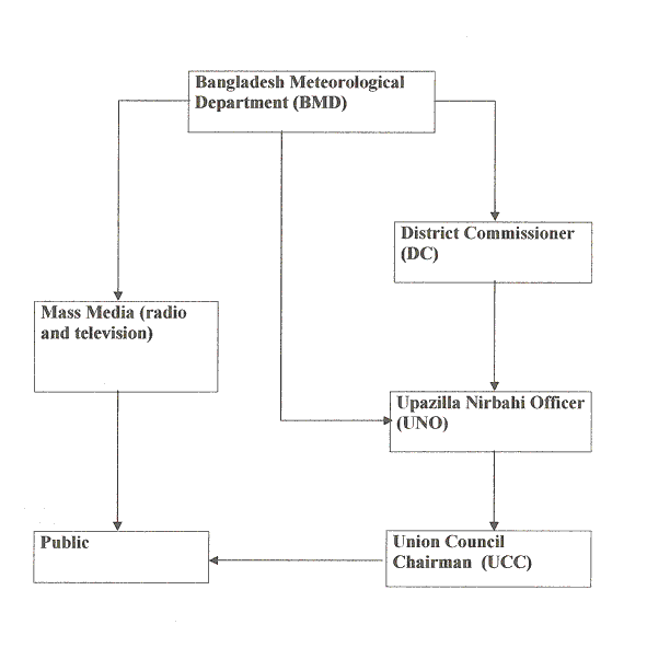
Figure 3: The flow diagram to show the ways that tornado watch and warning information should be delivered to the public by the Bangladesh Meteorological Department.