

Europes Flood Disaster of August 2002:
Viennas Evolving Flood Mitigation Projects
Jane Preuss
Planwest Partners
2005
A printable version of this QR report is available in PDF format.
This material is based upon work supported by the National Science Foundation. Any opinions, findings, and conclusions or recommendations expressed in this material are those of the author(s) and do not necessarily reflect the views of the National Science Foundation or the Natural Hazards Research and Applications Information Center.Citation: Preuss, Jane. 2005. Europes flood disaster of August 2002: Viennas evolving flood mitigation projects. Quick Response Research Report 175. Boulder, CO: Natural Hazards Research and Applications Information Center, University of Colorado. http://www.colorado.edu/hazards/qr/qr175/qr175.html.
Research Question
In August 2002 northern Europe suffered devastating floods. Although Vienna was spared the damage experienced by many major cites, other parts of Austria did not escape the devastation experienced elsewhere in Europe.
Prior to the floods, the principal investigator was aware that Austria took flood hazard mitigation seriously. Thus, the research question was two-fold:
- What types of mitigation strategies contributed to the reduced levels of damage throughout the country and
- Are any of the strategies transferable to the United States?
Research Interests
The research interest is to develop an overview of mitigation planning processes in Austria. A specific focus will be to explore regulatory influences on flood mitigation in Austria with an emphasis on the multidisciplinary efforts in Vienna.
Methodology
Using a four-part research methodology, compare the strategies in Vienna with other communities in Austria that did experience flooding:
- Unstructured interviews with average citizens:*
- Residents and merchants in Vienna
- Residents and merchants in Klosterneuburg (suburb east of Vienna outside of the flood project boundaries)
- Residents and merchants in Salzburg *Note: Conversations with respondents were not difficult to initiate because the flood continued to be uppermost in peoples minds. Once we started talking, I asked respondents about damage and impacts they experienced, what could have been done differently, and thoughts about recovery (e.g., insurance and tax reform). Since I speak German, all interviews were conducted in the German language.
- Interviews with representatives from the Water Programs Department, Municipality of Vienna (formerly Danube Restoration and Flood Control Project)
- Field inspections
- Vienna
- Klosterneuburg
- Salzburg
- Literature review
- Press reports in Austrian newspapers during August 2002
- News articles (newspapers and TV) during the first week of October 2002, including:
- High waters: tax break for victims mostly fall through
- Flooding and tax reformthe connections
- The 100-year flood: Record of the catastrophe
- Publications from the City of Vienna Department of Hydraulic Engineering: Flood Protection and Restoration, including:
- Viennas new river: Bringing nature and technology together
- Networking Viennas water bodies
- Hydraulic construction in Vienna
- Flood control on the Danube: Vienna
Background History
Flooding in the vicinity of Vienna has been well documented from as far back as the Roman occupation. The conditions reflected Viennas location within a highly volatile river system. Historically, the Danube waterway was comprised of a complex network of streams covering a floodplain forest up to five kilometers wide. The continuous flooding, with its attendant geomorphic changes in channel configuration, resulted in extensive damages, rendered navigation unpredictable, and interfered with the citys growth as the capital of the powerful Hapsburg Empire.
Since the early 15th century when a canal was constructed, multiple proposals to regulate the Danube were promulgated to reduce the unpredictability of the rivers impacts. Finally, between 1869 and 1875 Kaiser Franz Joseph undertook an ambitious project to regulate the Danube. The Regulation created a straight continuous channel and severed hydrologic and habitat connectivity. The Regulation also hardened the rivers banks and reduced the floodplain; the Danubes new bed measured now only 280 meters in width and was adjoined by a 450 meter floodplain on the left bank with a dike to protect the flat, low lying marsh area. A natural high bank on the right side facing the old city was expected to provide protection from high water. Disastrous floods in 1897 and 1899 raised doubts concerning the calculations used to design the embankments; however, over the next half century, concern about flooding took a back seat to economic and political decline and major wars.
Flood Control Evolves into Flood Hazard Mitigation
Ecological Effects of Regulation
The damaging floods of 1954 confirmed the regions vulnerability to serious flooding. By this time, ecological effects of the Regulation had also become evident. In effect, the straightening severed the network of tributaries, known as the arms of the river, interfering with hydrologic circulation between the now isolated streams. Stagnation, a tendency to silt up, and reduced water quality also ensued, together with a drop in groundwater levels. Replacement of the five kilometer wide floodplain with hardened banks also eliminated important habitat for terrestrial and aquatic species and interrupted migratory routes. Significant reduction in bio-diversity was noted.
Phase 1: Flood Control by Improving Flood Storage
In 1957 the Flood Control on the Danube Vienna project was created to oversee improvements to reduce flooding. The decade of the 1960s was devoted to design, including calculations to establish the design flood, acquiring financing, and acquiring property. In 1970 legal authorization for construction was issued; construction began in 1972. The flood control project designed in the late 1960s and completed in the 1980s had four key objectives (not all of which pertained to flooding):
- Increase flood storage capacity
- Create recreational opportunities
- Improve groundwater quality in the vicinity of the Danube
- Improve the transportation connections between the left and right banks of the city
Phase 1 had two principal components pertaining to flood hazard reduction: 1) constructing the New Danube canal and 2) creating the Danube Island between the New Danube and the Danube. The New Danube, a bypass channel parallel to the Danube, is approximately 20 kilometers long and an average of 200 meters wide. It is primarily fed by groundwater.
The Danube Island, which ranges in width from 70-210 meters wide, extends virtually the entire length between the New Danube and the Danube (see Figures 1 and 5).
The underlying purposes of the Danube Island, together with the New Danube channel, are flood storage and improved water quality. Additional features of the canal/island include opportunities for surface water circulation. To maximize filtration (separation of contaminants), impervious surfaces are restricted, and banks on the island and the New Danube have been designed with natural habitat to ensure bank-filtration and avoid plant species that had contributed to nutrient reduction in the Danube. Cars are not permitted on the island.
In addition to its flood hazard reduction and water quality enhancement functions, the Island, with its bird habitats, small boat marina, and biking and walking trails, has become an important site for urban recreation.
Phase 2: New Dynamic: Restoring Networks
Since the early 1980s the engineering flood control approach has been replaced by a multidisciplinary effort to re-network the rivers and streams that had been isolated during the Regulation. Objectives are to reconnect both surface and ground water to reduce flooding and pollution, and also to restore terrestrial and aquatic habitat. The motto of the new dynamic is:
- From single purpose flood control to multifunctional planning
- From engineering to interdisciplinary
- From individual projects to networking water bodies intended to:
- Improve hydrologic connections
- Improve aquatic and terrestrial habitat connections
- Recreation interconnectivity
An important goal of the networking project is to reestablish continuous ground and surface water circulation in priority tributaries that were part of the system of arms prior to Regulation. In 2002 (my visit) two of the arms had been reconnected and two more were in the design stage.
The Old Danube was the first tributary to be reconnected. It is envisioned as a central transfer point for the surrounding streams; it will become the heart of the network in terms of both surface and ground water flow regimes. Another aspect of the networking project is habitat enhancement. Circulating water through an additional watercourse will preserve natural habitats for animal species and for recreation. It will also improve connections between various habitat and landscape zones and enlarge the habitats of a number of plant and animal species. Extensive sections of the Danube and the lower Old Danubes banks that had been hardened during the Regulation are being returned to a more natural vegetative state, including replacement of reed species that had depleted valuable nutrients from the water with more desirable species to increase self cleansing. In addition, meanders and refuge/habitat sites are being recreated (see Figure 2).
In 1987 the former meadow wetlands east of the Danube, which had been cut off from the main stem by the 1870 Regulation, were declared a nature preserve. It is not surprising that severe environmental degradation, including a drastic reduction of the groundwater level, had occurred. This nature preserve was integrated into a national park in 1996 and because of the restoration efforts is now recognized by the United Nations Environmental, Scientific, and Cultural Organization (UNESCO) as one of Europes premier examples of biodiversity. Two tributaries flowing through the park are part of the reconnection program.
Implementation and maintenance of habitat restoration have not been limited to government programs. Dismantling the hardened banks and installing ecologically appropriate vegetation are widespread efforts. Schools and volunteers, as well as community service activities and such special days as Earth Day in the United States have all contributed to these efforts. Virtually all of the schoolchildren that I talked to had taken part in bank restoration and/or planting.
Concluding Observations on Vienna
The Danube restoration project has been underway for over 30 years. In 1975, before the New Danube and Danube Island had been completed, there was a damaging flood. In contrast, direct impacts to Vienna were minimal in 2002. Planners had used the worst flood of record, i.e., 1501, as their benchmark for the design event modeling. The 2002 flood was the first test of the calculationsand the flood crest was just below the 1501 event. Since the city has spent so much money on flood mitigation, respondents I spoke with were relieved but not surprised to have avoided flooding. It should be noted however that many residents of Vienna have second homes that did not escape damage. There was also a great deal of concern about the national focus that would essentially divert national funds to help to pay for damage repair in less proactive communities.
Other Communities
The results of Viennas multidisciplinary efforts were dramatic when contrasted with communities to the east and west that experienced significant damage.
Klosterneuburg
This bedroom community, approximately 45 minutes east of Vienna, until recently primarily accommodated weekend and summer homes that were not intended to be permanent. In the last decade newer homes have been built that conform to modern building codes. Homes within the floodplain are required to be elevated.
According to news reports, several homes were lost, two by fire caused by an electrical short. Firefighting equipment could not get through because the road was blocked. Interviews with impacted residents revealed that there was a great deal of property damage from mud. The insides of elevated homes were not damaged.
Insurance issues had not been resolved at the time of my visit. Claims for primary homes were covered through homeowners polices, although the amount and eligibility was often at issue if the home was a second home (which was generally the case).
Salzburg
The area around Salzburg experienced two types of flooding: within the center city and outside of the city on the peripheries.
Center City Flooding
The banks of the Danube as it flows through the old town of Salzburg had been hardened. In those areas the waters overtopped the banks (see Figure 3).
Outside of the city center the Danube flows through agricultural lands that have been held as greenbelt. Building permits are not issued until development densities within the urbanized areas reach a specified threshold. These agricultural areas are specifically held for flood storage. In recent years the population of Salzburg has grown and, accordingly, urbanization has encroached into the greenbelt/urban reserves.
Flooding on the City Peripheries
As mentioned above, the greenbelt is agricultural land with streams flowing through the fields and into the main stem. It was reported that flooding was experienced down one side of the road, but not the other. Owners attribute the difference to informal dike construction. Essentially, a diking war was taking place as some farmers constructed higher dikes than their neighbors. Flooding occurred in the areas of the lower dikes.
Conclusions and Comparisons
The Vienna case is a dramatic example of the multidisciplinary nature of flood hazard mitigation. It also dramatically illustrates both the difficulties and possibilities of restoring ecological functions.
Flooding and flood conditions have been documented in the Vienna area for as long as documentation has been available. Flood control efforts have been attempted for over 500 years. Serious flood control was implemented 150 years ago. This long-term perspective gives valuable insights into the effects of flood control, including adverse implications when ecological interrelationships have not been considered.
Viennas project (see Figure 4) clearly demonstrates that floodplain restoration is an interdisciplinary and cooperative undertaking. Interdisciplinary cooperation has included hydrologists, hydraulic engineers, hydrogeologists, geotechnical engineers, biologists, landscape architects, urban planners, and others.
The capacity calculations conducted in conjunction with construction of the New Danube canal and the Danube Island provided sufficient storage capacity for the 2002 event. More significant lessons pertained to lack of a national insurance vehicle to assist victims in other parts of the country. Flood hazard mitigation appears, however, to be essentially a local effort. Nationally, agricultural greenbelts are regulated for growth management. In urbanized areas such as the suburb east of the project, local regulations govern, including a delineated hazard area and a requirement that homes be elevated in those areas. While I was in Austria, Parliament was discussing the possibility of creating a Federal Emergency Management Agency type agency. To date such an agency has not been created.
The ecological restoration project is a significant undertaking that at this point is considered to be a permanent agency of the municipal government. It is intended to continue for many decades with continuing and widespread participation from all levels of government as well as by private and volunteer groups, including schoolchildren.
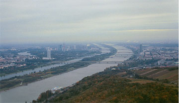
Figure 1: Phase 1 of the Flood Damage Reduction Project: New Danube in the foreground, Danube Island, and the regulated Danube.
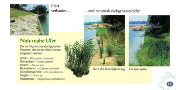
Figure 2: Bank Restoration: Replacement of hard surface with vegetation; photos on right show initial planning and one year later.
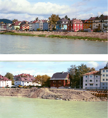
Figure 3: Salzburg: Bank overtopping occurred adjacent to residential sector of the old city.
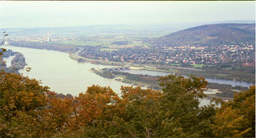
Figure 4: Confluence of the Danube and the New Danube, with Danube Island in the middle. Note reconnection and restoration of habitat in upper left foreground.
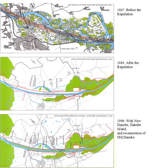
Figure 5: History of Danube waterworks.