Hurricane Katrina: GIS Response for a Major Metropolitan Area
Andrew Curtis
Jacqueline W. Mills
Jason K. Blackburn
John C. Pine
Louisiana State University
Baton Rouge, Louisiana
2006
A printable version of this QR report is available in PDF format.
Any opinions, findings, and conclusions or recommendations expressed in this material are those of the author(s) and do not necessarily reflect the Natural Hazards Center.Citation: Curtis, Andrew, Jacqueline W. Mills, Jason K. Blackburn, and John C. Pine. 2006. Hurricane Katrina: GIS response for a major metropolitan area. Quick Response Research Report 180. Boulder, CO: University of Colorado Natural Hazards Center. http://www.colorado.edu/hazards/qr/qr180/qr180.html.
The Days Leading Up to Katrina
One of the risks of residing in coastal Louisiana, and specifically in New Orleans, is the threat of being in the path of a major hurricane. Although the risk of hurricanes is a fact of life each year along both the Gulf Coast and the Atlantic Seaboard, New Orleans is in an especially dangerous position due to its geography, which is often characterized as a bowl. This shape describes the city’s elevation as below sea level while surrounded by higher land and water bodies, most notably Lake Pontchartrain and the Mississippi River. The hazards posed by this physical situation are compounded by the underlying demography of the city, which has a disproportionate indigent population with poor access to modes of transportation. The fear of Louisiana was that a major hurricane would directly strike a city still full of people unable to leave or cope with the subsequent flooding. This fear became a reality during Hurricane Katrina.
This report is based on the firsthand observations of a team of faculty, a research associate, and a graduate student who helped craft an organizational response to a request by the State of Louisiana for geographic information systems (GIS) in support of emergency response efforts associated with Hurricane Katrina. Our team represents extensive experience in working with public and nonprofit agencies in support of GIS activities, including emergency response. One member of our team, serving as a research associate, is an Louisiana State University (LSU) PhD graduate (2005) in geography and a displaced Tulane University Law School student. The purpose of this report is to share our experiences in helping to set up and operate GIS within the Louisiana State Emergency Operations Center (EOC). Many other faculty, research associates, and graduate students, including those from the Southern Regional Climate Center, LSU Hurricane Center, and LSU Center for Study of Public Health Impacts of Hurricanes were involved in the GIS effort, which was staffed from September 1-12, 2005.
Hurricane Katrina first threatened the Atlantic coast of south Florida, making landfall Thursday, August 25 as a category 1 hurricane. Katrina continued into the Gulf of Mexico, where its intensity grew, and its path changed toward the northern Gulf Coast. On the afternoon of Friday, August 26, it was predicted to make landfall around the Florida and Alabama border, missing the Louisiana coastline completely. However, by that Sunday, Katrina was a category 5 hurricane and eventually struck land to the east of New Orleans as a category 4 storm on Monday, August 29 (Figure 1). As one colleague who helped in our GIS response stated, "I left New Orleans that afternoon on a scheduled trip to Baton Rouge. The latest weather information showed Katrina missing us, so I continued with my weekend plans. By Saturday afternoon, I thought I would not be going back into the city for a few days. I had no idea that I would not be going back for over a month and that the city I would return to would not be the city I left."
Katrina Hits, Levees Break, and We Respond with GIS
When Katrina finally made landfall, information flow was understandably sparse due to widespread power outages that blanketed southeast Louisiana. It took several days into the aftermath for our group of geographers to be called in to help with the emergency response. A formal request by the Louisiana EOC was made through LSU staff providing climate scientific support to the EOC. Computers were moved to the EOC on September 1 from LSU. It was the following weekend of September 3, when we gathered to discuss the management and staffing needs of the GIS desk at the EOC. Two LSU staff members had been at the EOC throughout the initial response. This clearly was not enough personnel to field the round-the-clock requests, many of which were time sensitive, from all the agencies involved. It was decided to implement a schedule with two to three people in the EOC to cover a daily shift beginning at 5:00 a.m. and concluding at 10:00 p.m., though this immediately changed to a 24-hour presence. The levee breaches of August 29, made this GIS response doubly important because many people who had sustained little life-threatening damage from the hurricane were now in mortal peril from the rising floodwater.
What We Encountered in the Early Days
Katrina's northward movement brought considerable damage to coastal and inland Louisiana even before landfall. Though Baton Rouge is situated in a more protected area than New Orleans and the coastal communities, most of us were without power for days and weeks after the hurricane’s landfall. An absence of power in August, with both temperatures and humidity in the 90s, proved to be a miserable experience.
We often reminded ourselves that there were many others in far worse situations than ourselves; many families did not know about loved ones, and even more were looking at the prospect of never returning to their homes. The situation is worth mentioning because many of the workers on the EOC desk, already exhausted and heavily stressed because of the tasks being performed, often found sleep an impossibility due to these conditions at home.
This was not the only distraction during this period. Not only was Baton Rouge in distress due to power failure and a rapid influx of evacuees, but many Baton Rouge residents have friends, family, or property in New Orleans. One member of our team had not heard from his family in Washington Parish making it hard to rely on him to perform to the height of his abilities. This situation was accentuated because the individual was a key player on the team.
We were helping in a substantial way to save lives; however, keeping emotion out of the EOC was difficult at times. Tears, short tempers, and frustration occasionally became evident in our group, but everyone succeeded in keeping these to a minimum. The highest level of professionalism was maintained at all times through this response effort, and we came to appreciate the strength of people who had previously only been acquaintances in our department. The situation we faced has probably been encountered many times before. We, as responders, were likely to be personally affected by the tragedy, and yet at the same time our familiarity made us invaluable to the many outsiders who were drafted into the response effort.
Types of GIS Requests
The early days of the response were focused on search and rescue. More often than not, requests were from pilots needing imagery of the New Orleans central business district, coordinates of buildings where people had gathered and now needed rescue, and data on tower locations that could be obstacles on the flight path.
The Public Health Service needed to know locations where they could set down helicopters to check communities and assess the needs of local clinics and hospitals. For this task, we utilized Google Earth and came to rely on this resource for its ability to provide imagery, to batch geocode addresses that were then overlaid on the imagery, and to allow input of shapefiles onto the imagery along with three-dimensional visualization of these composite data (Figure 2). This company provided excellent support to our EOC effort through this crisis.
The locations of at risk populations, such as nursing homes and hospitals, were also very important. Another consistent request was for road maps overlaid with flood data. Many of the responders were not local and therefore did not know how to get around Baton Rouge, New Orleans, and surrounding areas. The Louisiana State Police frequently needed New Orleans road maps for troopers who escorted buses on rescue missions. Due to the high volume of their requests, one of our volunteers went to the local bookstore to buy all of the New Orleans road maps. Using GIS to create these maps was a duplication of product, since it already existed. However, it was not too long before Baton Rouge stores ran out of New Orleans road maps. Interestingly enough, a couple of weeks later, no road maps were available for Lake Charles after Hurricane Rita’s landfall.
One of our particularly resourceful volunteers was a map librarian who had the good sense to contact Rand McNally for a pdf file of their New Orleans road maps. With this file, we were able to provide both paper and electronic maps to response personnel.
Once responders saw the utility of Google Earth, in addition to serving agency requests, many also wanted to see their house or a friend’s house. Common questions were, “Is my house flooded?” and “If I give you an address, could you see if it is flooded?” Again, many of the people responding were also people who had been affected by the catastrophe.
Systems We Implemented
Three persistent sources of inefficiency emerged as we worked day and night in the EOC: data organization and access, the chaotic work environment, and request tracking. First, organization and access to data was difficult. We knew the data we needed was out there–somewhere. One of the most helpful resources in our endeavor to manage the voluminous amounts of data necessary to meet the needs of the Katrina GIS response was the CADGIS (Computer Aided Drawing Geographic Information Systems) lab at LSU. This lab is jointly supported by the Department of Geography and Anthropology and the College of Art and Design. It is responsible for the Atlas Web site, a GIS clearinghouse for spatial data in Louisiana (Figure 3). With additional support from two other vital LSU resources, the Louisiana Geographic Information Center and the LSU World Health Organization Collaborating Center for Remote Sensing and GIS for Public Health (WHOCC), data was provided to compose base maps for the affected areas. Also, through CADGIS, a large data server was developed at LSU to support not only the emergency response operations but to maintain data for the research community. This data server, also known as the FEMA-Store, provided a basis for Hurricane Katrina data access, sharing, organization, and archiving.
Second, the EOC is hardly a quiet place for concentrated work. It is made all the more difficult by the announcements that are wholly unrelated to the task at hand for the mapmakers. Because concentration and quick production are essential aspects for an effective GIS response, a separate room that serves as a workshop would have been ideal. In this workshop, computers, printers, and plotters dedicated to the GIS effort would be present. For weeks, we were housed in a cubicle alongside every other agency, sharing printing resources with them, while needing to print products, such as 20 color map books of New Orleans containing street network and flood overlay. This situation was far from ideal.
In the first few days of response, two additional computers were brought in to the EOC for GIS work. Unfortunately, these machines were not the most updated and caused more frustration than accomplishment. Fortunately, the LSU WHOCC donated several new, faster machines, which made work much more efficient. In addition, this lab donated a plotter. These additions solved some of the frustration with the initial inability to print large-scale maps at the EOC. CADGIS also assisted our efforts by acting as a host and workspace for GIS analysis and printing requests. Due to the chaotic work environment and lack of dedicated space for GIS at the Louisiana EOC, two labs within the CADGIS system became dedicated to the GIS response. These labs were staffed by students, GIS consultants, faculty, and staff who were available to create requested products, then send them back to the EOC as pdf files, so that they could be printed on the plotter at the EOC.The third issue we faced was keeping track of the requests and their associated information, such as contact information for our numerous clients and products and files used in making their products. This was needed so that we could replicate products with updated information, which was a frequent request by many agencies. For example, we needed to provide daily updates on shelter locations, which were opening quickly in the early days of the aftermath and then, after a few weeks, were closing, moving, or consolidating. Locations of flooded and passable roads also needed daily updating, as did the location of hostile activity in the city.
For these products, there was no reason to re-create the wheel each day, but simply to acquire and present the new information in a consistent template, so users could compare the daily changes. Since we had a rotation of volunteers, some were regulars and some could only come in a few times, knowing where people put files and what template they used became a challenge that added unnecessary frustration.
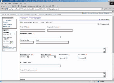
To address these organizational complications, the Southern Regional Climate Center (SRCC) in the Department of Geography and Anthropology at LSU created a replica of their tracking system for GIS projects. This online system allowed us to assign projects to various volunteers, quickly communicate with all members of the response team and support personnel, and maintain a copy of all products with a tracking number and all relevant file and contact information attached to the tracking number (Figure 4). This method provided real time organization and a record of our work for future reference. It was a much improved system from our paper files, which did the job, but not as effectively as the SRCC system.
Expanding Our Efforts
At first, it is fair to say that we were a bit overwhelmed at how fast we had to work. None of us had ever been in such a situation before. The scale of this disaster meant that everyone involved in the EOC was operating in unknown territory. As we attended to everyone’s mapping and information needs, it became apparent that for some requests we were simply accessing publicly available resources, gleaning data from them, and then passing this information along to the client.
To streamline data access and increase everyone’s efficiency, we began showing people how they could access Web services, such as Mapquest.com, to find the location of an address, or Google Earth to look at predisaster imagery with address points on top. All were grateful because it saved them a trip over to our desk (a congested area in the EOC) and allowed them to see quickly what they needed without waiting in a queue, even for a few minutes. This was one of the milestones of a rapid increase in everyone's efficiency.
In addition to educating users on quickly available public information, we also implemented a data-sharing resource, the FEMA-Store server. Housed at CADGIS, virtual private network (VPN) client software provided us remote access to this resource where all spatial data was stored and where we created new data.
Not only did FEMA-Store allow data organization, it also facilitated data sharing. An early problem was the logistics of data sharing from multiagency sources. Initially, some individual files were sent to us via e-mail. This limited the size and security of the information, thus this method only allowed us to accumulate nonconfidential information that was small in size. With FEMA-Store, select members of various agencies were provided access to deposit spatial data for our use in the EOC. Access to this resource was limited due to the need to provide security for some of the data sets.
Initially, interagency data sharing was an essential component of FEMA-Store for providing the most complete data for the most informed maps and information for decision support. When the Federal Emergency Management Agency (FEMA) mitigation team arrived, however, it also became a resource for their mitigation efforts, which were also facilitated through the CADGIS lab at LSU.
Preserving Data from Our GIS Response
The GIS response to Katrina was a success, though it could have been less frustrating and more efficient in the early days if a detailed, well thought-out plan had been established to direct our activities. Fortunately, we all worked well “on the fly.” Even with a plan, GIS responders need to be flexible in adapting to the dynamic and rapid needs of a large-scale natural disaster.
One of the best resources we have for preparing for the next major event is the lessons and data accumulated from this catastrophic experience. If we do not preserve this data and use it for research purposes, then we have wasted time and energy and done a great disservice to those who will be affected by the next major hurricane. For these reasons, this data is being archived and made accessible to the research community at FEMA for mitigation and long-term recovery and to the LSU researchers who provided support and want to explore the data to improve our knowledge for the next time.
Admittedly, archiving data was not our first thought as we rapidly responded to the needs of search and rescue teams and law enforcement officials. However, as requests became more duplicative in nature with slight variations, archiving our data made the job more efficient. Not only were map layers and imagery stored but so were the finished products. For example, law enforcement constantly needed road maps of the New Orleans area with the most current FEMA flood data overlaid so that they could determine their routes. Instead of reinventing this data several times a day, we created a file for state police. Within this file we kept the original and updated files along with each finished map. This data is now archived in FEMA-Store so that it can be accessible for future training for the state police, and they can have records of what they did where.
Another example of a problem we encountered was mapping the location of hostile fire. Field data acquired by state police was passed on to us to create a map of the dangerous areas. The hostile areas were mapped by “heads-up” digitizing the red areas shaded onto a street map brought to us by a state police officer. No metadata was created because as this request was being processed, others just as important were being generated. When the hostile data was complete, the situation dictated a swift transfer to a new project. This demonstrates the typical mapmaking process in the EOC.
When working only on local computers or in a large set of folders on a network, unless intuitively named and saved in a predetermined location, data is easily lost or, at a minimum, difficult to track down. This is especially frustrating when every job is marked “high priority,” creating a pressurized environment of expectations. Also, preserving this data for the FEMA mitigation group proved important to their ability to see which areas were affected and to what degree. With this information from imagery, their data, and our data, they can more effectively plan a mitigation strategy for the rebuilt New Orleans. This data is available through FEMA-Store.
From a research perspective, issues such as social vulnerability and types and locations of emergency response calls can be more effectively studied using our data. Maintaining this information is important to training search and rescue teams and law enforcement officials in future issues of disorder and identifying locations where such issues may arise. Understanding environmental impacts, safe havens that maintained structural stability, neighborhoods susceptible to damage from levee breaches, and places that did not flood will be important for targeting specific areas for mandatory evacuation. By archiving this information, we can use it to more thoroughly understand the spatial variation of risk. The data will promote our understanding and allow us to provide feedback for future preparedness with the knowledge gained through this response.
Lessons Learned for the Next Time
Though the response to Katrina has been criticized in the media, this storm and its aftermath occurred at a scale that had not been experienced previously in the United States. Many preparedness measures, including a comprehensive GIS at the EOC, were not in place. Acknowledging this fact and that our team was composed of academics who utilize GIS as a tool in their research and are not emergency responders, our efforts effectively supported the needs of the EOC. Many of our clients stopped by our EOC desk to thank us and to tell us that we helped them to save lives; they wished they had us permanently and would like to have us on their team again in response to a future disaster. Given such unsolicited positive feedback in the face of a heavily criticized response effort, we know our long hours and expertise provided an integral service to the personnel in the situation rooms and on the ground. From this experience, we have learned some lessons that will hopefully provide the next group of GIS responders the ability to get up and running quickly without the inefficiencies we encountered.
Some of the issues we faced are also reflected in the lessons learned from those providing GIS response for 911 in New York. Most prominently, we observed that much of our work to accumulate data in the early hours and days of Katrina should have been done in anticipation of a hurricane event. In addition to data accumulation are the issues of communication and data sharing. The logistics of how we, as volunteers, were to operate in such a situation should have been preplanned. Thomas et al. (2002) notes, “The post-event response experiences in New York City support the premise that geo-technologies can and do support response efforts. While they contain a wealth of valuable information, real-time or near real-time geo-technology efforts are resource intensive and require significant pre-planning efforts in order to perform most effectively." All emergency preparedness groups should have a plan for their GIS unit, not as an ad hoc component, but as an integral resource for all other operations.
External hard drives with data organized in an intuitive structure, abbreviated metadata protocol, and standards for the layers created for emergency response are a few of the major issues that need preplanning. Developing a simple text file noting projection, date (pre- or postevent and date created), and who created it is an adaptation needed in what R.W. Greene terms “combat GIS” (Greene 2002). Additionally, a template with standard images and logos, fast machines, printers with appropriate software already installed, and a plotter are also needed. Cisco VPN Client was an invaluable help to us as it provided secure remote connection to our FEMA-Store server. This connection created a central location for data access, creation, and backup.
Some of our responders list the following as considerations for the next group in this situation:
- Put everything on the network; never save to a local file.
- Place appropriate logos on the maps so clients know where they came from.
- Insert network path name on map products so the next volunteer can track it down quickly.
- Anticipate that technological problems will occur and have a plan that minimizes how they might slow down the response.
Personnel need to be quick with GIS skills and slow to be overcome by stress. The best people for an EOC setting are not necessarily those with advanced spatial analysis skills but the people who can quickly and correctly geocode, overlay images with shapefiles, and provide assistance with the aesthetics of the graphic. It is also important not to overstaff or under staff the EOC. In our operation, we found that we were most effective with no more than one or two people per computer, a runner for copies, or someone with exceptional calm and personal communication skills to provide customer service and translation between what the client wants and its interpretation into a map.
It is important to have an established plan that includes the use of volunteers in the GIS response. We have learned from September 11 and Katrina that more than likely, volunteers will be a part of the initial response. Although using GIS was a plan of the Louisiana EOC, due to some political overhauling of the agency, GIS support was not as organized as it could have been. Thanks to some LSU folks pooling resources, we provided a small volunteer army of faculty, staff, and graduate students who had the skills, dedication, and endurance to provide combat GIS. During September 11 and Hurricane Katrina, volunteers provided much of the early GIS response. Those employed in these positions may have been impacted by the disasters themselves or may not have been in the immediate area, necessitating travel time between their location and the EOC, which could have been hampered by disruptions in transportation routes. From our experience and from what was written by those involved in September 11, volunteers should be a part of any area’s GIS response plan.
An established data source is also needed for base mapping. Although most of us spend our days conducting spatial analysis and modeling, advanced GIS skills are not needed at this point in a disaster. What is needed are people who are skillful in the basics and have access to a broad set of data for base mapping. As previously stated, the bulk of the types of mapping we created were base maps with various amendments made on a daily basis or as updated information became available.
An essential component to the base mapping is the road map. Road maps that are pre-shelved in the EOC, can be printed out, and are also available in pdf form are essential resources for emergency responders, especially those who are unfamiliar to the area. In addition, even for local responders, the affected area may not look like it did before the disaster; therefore, they need to be able to quickly find alternate routes that will allow them the most efficient way to perform their duties.
Conclusions
Much of what was learned from our experience echoes the experience of GIS responders during September 11. However, the sheer size of the affected area and the number of people impacted by Katrina certainly threw this GIS response into a much larger scale of effort. Whereas the response phase of September 11 was limited to a known location and population, the response to Katrina continued for weeks as the affected population and geographic area was largely unclear at first and changed with levee breaches and the aftermath of Hurricane Rita.
Two of the main findings that can enable greater efficiency in GIS response to a similar disaster are the need for 1) a specific response plan that includes the use of volunteers early in the response and designates these people well before a disaster; and 2) digital and paper copies of existing products for standard requests, such as road maps for the impacted areas, which save time, money, and personnel from duplicating efforts on a product that is already available. In combat GIS, especially of the scale we provided for Katrina, time is of the essence, and that makes organization before the storm an integral part of a successful response.
Acknowledgements
This effort could not have been as successful without the support of the following groups: LSU CADGIS Research Laboratory, LSU Center for Study of Public Health Impacts of Hurricanes, LSU College of Design, LSU Department of Geography and Anthropology, LSU Earth Scan Laboratory, LSU Southern Regional Climate Center, LSU World Health Organization Collaborating Center for Remote Sensing and GIS for Public Health, Louisiana Department of Natural Resources, Louisiana Geographic Information Council, Louisiana Geologic Survey, and the U.S. Geological Survey.
References
Greene, R.W. 2002. Confronting catastrophe: A GIS handbook. Redlands, CA: ESRI Press.
Thomas, Deborah S.K., Susan L. Cutter, Michael Hodgson, Mike Gutekunst, and Steven Jones. 2002. Use of spatial data and geographic technologies in response to the September 11 terrorist attack. Quick Response Report 153. Boulder, CO: University of Colorado Natural Hazards Center. http://www.colorado.edu/hazards/qr/qr153/qr153.html.
Figure 1: Hurricane Katrina's Path
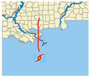
Figure 2: Google Earth in the EOC

Figure 3: Atlas Web Site
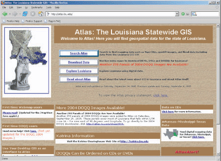
Figure 4: SRCC Tracking System for GIS Projects in the EOC