 Return to Hazards Center Home Page
THE ENVIRONMENTAL IMPACTS OF FLOODING IN ST. MARIES, IDAHO
1997
Return to Hazards Center Home Page
Return to Quick Response Paper Index
This material is based upon work supported by the National Science Foundation under Grant No. CMS-9632458. Any opinions, findings, and conclusions or recommendations expressed in this material are those of the author(s) and do not necessarily reflect the views of the National Science Foundation.
This paper looks at the range of environmental impacts of flooding as they exist immediately following an event. The flood hazard is then seen as a strategic problem that can be addressed through environmental impact assessment techniques.
Some progress has been made, particularly with the National Flood Insurance Program and its associated zoning regulations and floodproofing requirements that place restrictions on new development (Federal Interagency Floodplain Management Task Force, 1992). The intent is to minimize reliance on flood control structures, to phase out uneconomic development, and to force floodplain residents to insure against individual losses, thus reducing the need for community-based relief. Nevertheless, with the exception of water and sewage systems, environmental impacts of development are generally ignored.
Reasons for this lack of consideration of environmental impacts emanating from flooding are relatively straightforward. Most basically, flood concerns have historically been regarded as economic issues associated primarily with direct damages. In essence, the underlying philosophy has been one of costs versus benefits, while focusing attention on short-term economic variables, rather than consideration of the total range of impacts, including indirect and intangible losses (Handmer, 1988). Secondly, there has been overwhelming interest in relief and rehabilitation efforts and a prevailing desire to get things "back to normal" as soon as possible. Thus, the first step is usually to facilitate economic recovery from the flood and to meet the immediate demands of flood victims. The second step, it seems, is to plan for the next event, thereby initiating a continuing cycle of disaster-relief- repair-disaster. Ultimately, the flood risk and vulnerability do not change. Of course, society can and does learn from some events, to the extent that some communities have even moved off the floodplain, but these tend to be the exceptions rather than the rule (Alto, pers. comm., 1995; Tobin, 1992).
The environmental impacts of flooding can be quite wide-ranging, from the dispersion of low-level household wastes into the fluvial system to contamination of community water supplies and wildlife habitats with extremely toxic substances. On the other hand, flood preparedness activities, such as forecasting and warning systems, can help to avoid some of these impacts. Indeed, actions undertaken prior to the event will have repercussions on the level of damages accruing from the flood. Effective remedial actions, such as sandbagging, can significantly reduce losses, and with planning, prevent some of these secondary environmental impacts. Specifically, the removal of fuel tanks and attention to hazardous wastes would eliminate some of the potential problems. In contrast, inadequate attention to these components of the flood hazard will invariably lead to additional problems and intensify adverse environmental impacts. Similarly, during a flood, variables such as depth of water, velocity of flows, and duration of inundation, in combination with land-use attributes, all contribute to the relative severity of flood impact (Tobin and Montz, 1994). Floods of greater depth are likely to result in greater environmental damage than floods of lesser magnitude, in part because more area has been flooded. Long duration floods will exacerbate environmental problems because clean-up will be delayed and contaminants may remain in the environment for much longer time. The argument is the same for other flood traits; extreme conditions are likely to precipitate additional environmental problems.
During the post-flood phase, that is the clean-up stage, many other environmental impacts can become apparent. The volume of the debris to be collected, the extent to which public utilities such as water supply systems and sewage operations have been damaged, and the quantity of agricultural and industrial pollutants entering fluvial systems might present pressing problems. These findings, then, should be incorporated into long-term restoration and reconstruction programs to eliminate unacceptable environmental impacts from subsequent flooding.
Environmental evaluation of the flood hazard, therefore, sets the stage for the strategic assessment of redeveloping flood prone areas. Specifically, recurring losses and negative intrusions into environmen- tal systems could be avoided, or at least minimized, by identifying, measuring, and interpreting the magnitude and significance of environmental impacts associated with flooding.
Currently, there is a tendency to re-analyze the economics of redevelopment in the aftermath of an event, and rebuild with future losses in mind, assuming the provisions of the NFIP are met. It follows that a similar approach regarding environmental impacts would provide a comparable basis for decision-making. The guiding principle in this instance would be reducing costs related to environmental clean-up and providing additional protection.
Strategic environmental assessment (SEA) has been defined as "the formalized, systematic and comprehensive process of evaluating the environmental impacts of a policy, plan, or program, and its alternatives . . . and using the findings in publicly accountable decision-making" (Therivel et al., 1992). The application of this definition to flooding is apparent. Reconstruction of floodplains is a policy that is enabled through federal and state disaster relief funding and private money. Traditionally, this has followed the simple economic model discussed above. However, strategic assessment of floodplain reconstruction permits a comprehensive analysis of policy decisions, prior to the emergency phase immediately following a flood event. Since this is usually a period of chaos and confusion, such planning is essential if meaningful policies are to be implemented.
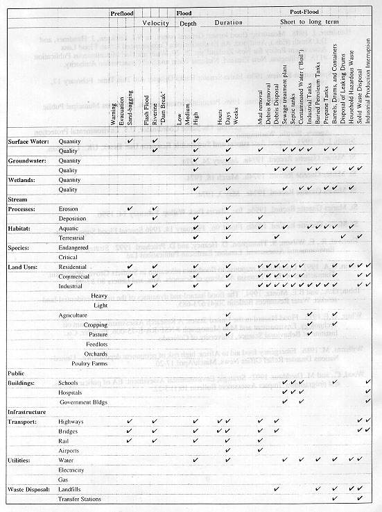
For the purposes of this research, we have utilized a simple matrix ( Figure 1 ), that would have relevance to workers in the field, to determine the immediate environmental impacts of flooding. Such an approach made it possible to evaluate impacts as they "flowed" through different components of the environment during the flood event, while also accounting for different spatial and temporal scales.
The matrix provided a framework, then, for identifying a range of potential environmental impacts. The matrix comprised three "stages" of flooding, pre-flood, flood, and post-flood, that would possibly affect the outcome of environmental impacts. Data were collected on components of the hydrologic, and ecologic/habitat systems, as well as on specific land-uses, structures and appurtenances, utilities, and transportation networks in the floodplain. A preliminary determination was made as to whether the impacts were severe or of small magnitude in each appropriate category. Spatial scale can be accounted for by using different matrices for each unit within the floodplain.
Floods in St. Maries have usually occurred as a consequence of rapid snowmelt and/or heavy rainfall on already saturated catchments. Occasionally ice jams have precipitated additional problems. A further hydrological concern is the power dam, built in 1906 downstream at Post Falls, that causes water to back up into St. Maries at times of high flows. During floods, therefore, water cannot escape downstream, if lake levels at Post Falls are high. Thus, to some extent, levels and duration of flooding are contingent upon operation of the dam at Post Falls (Currier, pers. comm ., 1996).
Response to the flood hazard at St. Maries has been typical of many floodplain communities. Small-scale, local, and ad hoc projects typified the first part of this century, and it was not until after the 1933 event that more serious consideration was given to protecting the community from flooding. This interest corresponds to the gradual involvement of the federal government in flood alleviation programs. Thus, by the early 1940s, the US Army Corps of Engineers (USACE) had erected dikes along the southern bank of the St. Joe River (Coeur d'Alene Press, 1996). Since then, the levee system has grown in height and extent so that there are now eight levee districts within the town, although only one is currently an official USACE structure. The two major levees, Meadowhurst and Riverdale, are 14,000 and 11,000 feet long, respectively, and protect large tracts of the town. With the construction of levees, small-scale flooding has been virtually eliminated, and major events are now associated with failures in one or more of the dikes.
The next stimulus for remedial action was the flood of January 1974. On this occasion, an ice jam and heavy rain combined to breach the Riverdale and Burden House levees and put serious pressure on the Meadowhurst levee (St. Maries Gazette Record, 1974a). Levees were reported to be like "jelly" and were reinforced with sandbags, as saturation continued for some time. It was in the months immediately after this event that city authorities passed a resolution calling for a floodplain ordinance as a first step to joining the NFIP (St. Maries Gazette Record, 1974b). This was accomplished in May of that year when the Department of Housing and Urban Development approved the ordinance (St. Marie s Gazette Record, 1974c).
Each of these floods not only devastated homes and businesses, but also wreaked havoc on the environment. For instance, the presence of timber mills on the floodplains meant that during every flood, fuels and other contaminants were carried away by flood waters. Similarly, household products, chemicals, and agricultural pollutants would have been washed into the fluvial system. In 1974, $5.5 million damage (1974 figures) was recorded for the county, which included damage to water supplies and sewage plants (St. Maries Gazette Record, 1974a). In addition, soil loss was reported from agricultural areas.
Thus, while St, Maries had joined the NFIP in 1974, very little of consequence had changed in the community that would prevent future floods, and nothing had been done to contain environmental contamination. By 1996, the last major event had occurred over twenty years earlier, so although the event probably remained a life benchmark for individual residents, it would have been of little practical value in fighting this most recent flood. Indeed, the community typifies the classic response to the flood hazard, with its almost total dependence upon a single flood alleviation measure, in this case, the levee system. While these structures have been very effective up to their design standards, they have failed, as shown in the past, and development on the floodplain has continued in spite of NFIP regulations. For instance, in 1995 Potlatch spent $6 million updating the dry kiln located in the most frequently flooded part of the town (Coeur d'Alene Press, 1996). The vulnerability of the community to the flood hazard, therefore, has not been altered.
By the morning of February 9, the levee system was in jeopardy. Leaks were detected on the Riverdale dike, and boils were observed in other districts. Attempts to plug leaks with sandbags were eventually abandoned for safety reasons. Several hours later, both the Meadowhurst and the Riverdale dikes were breached, flooding over 850 acres and more than 100 homes and 20 businesses (Coeur d'Alene Press, 1996; St. Maries Gazette Record, 1996b). This levee failure caused a temporary fall in flood levels until the floodplain filled with water. Other dikes also failed, including one protecting the airport, leading to the inundation of another 486 acres. By the end of the flood, there were two major breaks in the Riverdale dike, one 250 feet long, the other 40 feet in length. As the levees were repaired, pumps were installed to get water out of the low-lying areas. At one time, 43,000 gallons of water per minute were being pumped out of the Meadowhurst levee area (Currier, pers. comm. 1996). Water remained in the community for approximately three weeks.
Both the St. Maries and the St. Joe Rivers were contributing to the flooding. Unfortunately, there are no gauges on the St. Maries River, which presents difficulties for forecasting flood events with any degree of accuracy. Hydrological models, however, indicate that the St. Maries River usually contributes about 30% of the total flows, although this probably varies given different storm events (Currier, pers. comm., 1996).
Power was lost for a time, and the city sewage works was also damaged (St. Maries Gazette Record, 1996b). The sewage plant was flooded relatively early, and wastewater came over the top of the levee (Currier, pers. comm., 1996). Flood water entered the primary treatment area and excess wastes were pumped into the ground and river. Most of the city residences are connected to the city sewer system, although there are a few septic tanks in the Riverdale area. These, however, are connected to the main system through a series of pumping stations (Municipal Public Works Foreman, pers. comm., 1996). However, city authorities reported no major contamination associated with flooding of the sewage works, although no testing was undertaken.
A boil water order was issued by the Department of Environmental Quality on the basis that sewage, petroleum products, and micro-organisms could have contaminated supplies (St. Maries Gazette Record, 1996a). There was some criticism of this order, since St. Maries uses surface water brought from eight miles upstream at Rochat Creek and only utilizes a local well if surface supplies are short (Municipal Public Works Foreman, pers. comm., 1996). However, high turbidity levels, not unusual for this location, were used to argue for the order.
It appeared that no serious contamination had resulted from the flood, although some materials were tested to see if they were hazardous. Of the 238 samples tested, 107 proved positive. Chemical testing revealed primarily oils, grease, and some household chemicals, along with some agricultural pesticides, acids, and paints. Quantities were variable, with containers ranging from 1 to 55 gallon drums. Not all of these were full; many had clearly leaked into the surrounding environment. Barrels were stored temporarily at a landfill during the flood, eventually to be sent to a RCRA facility if hazardous. Visible evidence of contamination was not high. In places there was a thin film on the top of the flood water from petroleum and hydrocarbons, most of which was expected to dissipate or mix into soils. There was a possibility that such products could get into groundwater depending on the depth and condition of wells. Some of the contaminated areas had been boomed and absorbent materials used to soak up the wastes (Rodin, pers. comm., 1996).
The vertical axis of the matrix includes those environmental parameters that are expected to be affected by flooding, no matter what the location. The horizontal axis includes the activities or characteristics associated with flooding that are expected to cause an impact on one or more environmental parameters, whether positive or adverse. Those cells with a checkmark indicate a relationship between the activity and the environmental parameter. A more in-depth analysis of a flood event would allow for some measurement, if only relative, of the magnitude of these impacts. While this is preferred over the identification of impacts in Figure 1, sufficient data are not available for reliable measurements. Additional long-term research is required to develop measures of anticipated magnitudes. Nonetheless, some observations can be made from the matrix.
The range of impacts from different flood characteristics can be determined by reading down from a given category of activity. For instance, the existence of opened and leaking barrels in the flood area may have potential impacts on surface water and groundwater quality, on aquatic habitat and species, and on different land uses, depending on the amount and type of contaminants involved. In addition, the number of flood-related characteristics or activities that affect a given environmental parameter can also be identified. For example, surface water quality will be adversely affected by the velocity, depth, and duration of flooding as well as by flooding of the sewage treatment plant, by the tanks and barrels in the flooded area, by household hazardous wastes in the flooded area, and by debris and mud removal. As a result, water quality is subject to numerous intrusions, which, both separately and in various combinations, can be significant depending upon the contaminants released. Costs of dealing with this can be high, in terms of real dollars as well as environmental costs if contaminants move through ecological systems. And surface water quality is just one parameter affected.
This study indicates that some refinement in the ability to measure environmental impacts is needed. The overall approach appears to have merit and provides a useful framework for identifying potential environmental problems. Certainly the elements included in the matrix have relevance to St. Maries, as well as to other floodplain areas. As mentioned previously, however, the magnitude of impact could not be assessed, given the data available at the time of this research. Additional work is required. Nonetheless, the utility of the matrix in post-flood St. Maries suggests that it has the potential for wider application in pre-flood communities, where the exposure of environmental parameters to flood characteristics can be estimated prior to an event.
In the final analysis, therefore, assessment of the environmental impacts of flooding involves consideration of a range of interactions that do not usually enter floodplain management decisions, at least in any systematic way. It may be argued that flooding at a place is a rather rare event, and as a result, associated environmental impacts are equally rare and generally insignificant in the short-term. Yet, when we consider the flood hazard in the United States as a whole, environmental impacts are devastating. Losses from flooding are estimated to be up to $3 billion per year, a considerable proportion of which is spent by local, state, and national agencies on clean-up operations involving environmental problems (Federal Interagency Floodplain Management Task Force, 1992).
Because of recurring and ever increasing economic losses due to flooding, new policies have been implemented, most notably the NFIP, which to some extent account for flood risk. Consequently, there are now restrictions on floodplain development in over 18,000 participating communities (Emergency Information Public Affairs, 1995). A similar strategic approach, based on nature, magnitude, and significance of impacts, is recommended with environmental losses. To date this has not been done, in part because it has not been of sufficiently high priority to merit consideration. However, as the environmental impacts of the St. Maries indicate, environmental impacts and risks can be considerable.
Return to Hazards Center Home Page