Quick Response Report #95
THE IMPACTS OF A SECOND CATASTROPHIC FLOOD ON PROPERTY VALUES IN LINDA AND
OLIVEHURST, CALIFORNIA
Graham A. Tobin
Department of Geography
University of South Florida
Tampa, Florida 33620-8100
and
Burrell E. Montz
Department of Geological Sciences and Environmental Studies
Binghamton University
Binghamton, New York 13902-6000
1997
 Return to Hazards Center Home Page
Return to Quick Response Paper Index
This material is based upon work supported by the National Science
Foundation under Grant No. CMS-9632458.
Any opinions, findings, and conclusions or recommendations expressed in
this material are those of the author(s) and do not necessarily reflect
the views of the National Science Foundation.
THE IMPACTS OF A SECOND CATASTROPHIC FLOOD ON PROPERTY VALUES IN
LINDA AND OLIVEHURST, CALIFORNIA
INTRODUCTION
Natural hazards researchers have tried to trace the various social and
economic impacts of different disasters by examining changing property
values in hazardous areas. Some researchers have looked at earthquakes
(Brookshire, et al., 1985; Palm, 1982; Scawthorn, et al., 1982) while
others have focused on floods and floodplain locations. (Babcock and
Mitchell, 1980; Burby and French, 1981; Changnon, et al., 1983; MacDonald,
et al., 1987; Muckleston, et al., 1981; Sheaffer and Greenberg, 1981).
These studies have essentially had the same goal of modeling disaster
impacts, but their methods have differed and the findings have often been
contradictory. For instance, while it would seem reasonable to
hypothesize that an event like flooding would have a negative effect on
house values, this has not always been supported by the literature
(Muckleston, et al., 1981). This research theme has not been limited to
the United States. Studies in Australia (Lambley and Cordery, 1991) and
New Zealand (Montz, 1992) demonstrated an immediate depreciating effect
following disaster events with some continued impact over the longer term.
However, these studies also pointed out problems associated with trying to
separate hazard-related impacts from market impacts relating to other
socioeconomic and environmental variables.
It was in light of these studies, and particularly the confounding
results, that the authors embarked on a comprehensive assessment of the
relationships between flooding and property values beginning with Linda
and Olivehurst, California (Montz and Tobin, 1986). Preliminary research
findings demonstrated an inverse relationship between residential property
values and the incidence of flooding; to wit, flooding does have a
negative impact on property values under most circumstances (Montz
and
Tobin, 1987, 1988; Tobin and Montz, 1988). However, it was established
that local context was also important in determining the degree of impact,
both in terms of the physical attributes of the flood event itself, and
the socioeconomic traits of the communities involved (Tobin and Montz,
1994). Specifically, this research revealed the existence of housing
submarkets, defined by flood depths, within the floodplain (Tobin and
Montz, 1994). The earthquake hazard also illustrates the importance of
submarkets, wherein older brick buildings that do not meet building
standards regarding earthquake safety comprised a submarket (Alesch and
Petak, 1986). Submarkets were also identified in the communities studied
in Australia and New Zealand. However, most studies have been short-term
and were related to single events; what remains to be documented is the
longevity of these submarkets.
THE THEORETICAL FOUNDATION
The conceptual framework for this work was presented in Tobin and Newton
(1986) and is depicted in Figure 1. Briefly, the
graph presents three
scenarios following a flood (or other event). Immediately following a
flood, property values decrease because the utility that can be derived
from that parcel of land is reduced. Depending upon the nature of the
flood in terms of frequency and magnitude, recovery can follow any of
several paths, three of which are presented here. Line A represents a
situation where frequent flooding may keep land prices low relative to
non-flood areas. While the trend in property values may not be entirely
flat, any increases that may occur are negated by the next flood. Line C
represents the opposite situation, that of extreme flooding, either an
infrequent, perhaps a "once-in-a-lifetime" event, or catastrophic
flooding, or both. In this case, it is expected that property values will
decrease immediately after the event, but will recover eventually to
pre-flood levels, and perhaps rise even higher. Under other
circumstances, property values might recover over a time-frame somewhere
in between these two extremes (line B).
Research to date has verified aspects of this model. For instance, Des
Plaines, Illinois is a community that experiences relatively frequent
flooding. Although other dynamics of the real estate market had a
significant impact in this Chicago suburb, capitalization of the flood
hazard was apparent after the community experienced two floods
within a 10 month period, and five floods within 50 years (Tobin and
Montz, 1990). Similarly, in Wilkes-Barre, Pennsylvania, properties flooded
more than 9 feet in a catastrophic event in 1972 virtually replicate line
C on the graph in Figure 1. However, properties
flooded less than 9 feet
(the mid-range depth for this event) recovered rather quickly, and prices
exceeded pre-flood values within one year of the flood (Montz and Tobin,
1990). Thus, empirical evidence from several study areas tends to support
the theoretical base, though there are variations from what was expected
in some submarkets.
The Study Area - Linda and Olivehurst, California
Previous work in Linda and Olivehurst also serves to validate the
submarket findings. For example, the decrease in sold prices immediately
following the 1986 flood was followed by recovery to almost pre-flood
prices for those properties flooded to 18 inches, in keeping with the
model. However, properties flooded to 10 feet or more experienced some
recovery after the initial drop, but prices never got higher than 80% of
pre-flood levels, and later they experienced another decline (Montz and
Tobin, 1988). Therefore, it appeared that the flood was indeed
capitalized in property values, as hypothesized, and the data on
non-flooded property supported this contention. Furthermore,
characteristics of the flood were to some extent instrumental in
determining land values as shown by the different residential submarkets.
However, these findings were confined to the immediate two-year,
post-flood period. An examination of a longer time period, therefore,
would permit further evaluation of the extent to which the model continues
to apply and would provide a longitudinal test of the concept of
capitalization of the flood.
The opportunity to explore this more fully arose in January 1997 when not
only a second, but also a third "once-in-a-lifetime" event occurred in the
same communities as a result of two levee breaks. The levee systems have
been compromised on several previous occasions. For example, in 1955,
Yuba City was flooded when a Feather River levee failed; in 1986 another
levee break north of Linda allowed flood waters to inundate large areas of
Linda and Olivehurst, and most recently the 1997 events. Furthermore, the
relatively flat topography has only exacerbated the extent of flooding
once the levees failed.
The 1997 floods raised several interesting questions. First, how would
the second and third catastrophic floods in 11 years affect property
values in the newly flooded areas? Given that two floods in less than a
month represent very frequent flooding, they may, in fact, be so close in
time as to act as one event with regard to impacts on property values.
Second, the recent floods have all been associated with levee breaks,
which calls into question the efficacy of the local flood control strategy
along with use of the floodplain. Finally, it has been suggested that
frequent events would lead to continuously depressed property values while
low-probability, catastrophic events would allow prices to return
relatively rapidly to pre-event levels. The impacts on property values of
two large events in such close temporal proximity has not been examined.
Furthermore, the 11-year lapse between events may be sufficiently close to
the period in which past events might be forgotten, and hence the
situation provides an occasion to test the expectation theory postulated
by Yezer and Rubin (1987).
METHODOLOGY
The situation in the Yuba City/Marysville area provided an ideal
opportunity to further these studies. Two goals emerged; the first focused
on the new flooded areas (1997), and second concerned the 1986 flood
zones. In the first instance, the goal was to test previous findings
regarding the immediate impacts of flooding of residential land values.
It was recognized that this component would entail collecting important
background data on the residential housing market for a longer-term study.
The second goal involved a re-evaluation and updating of the old flood
zone data to (i) examine the length of the recovery period for residential
real estate market following catastrophic flooding and (ii) test
further the significance of the residential submarkets over the long-term.
Thus, the research focused on both short and long-term perspectives of
catastrophic flooding.
Goal One
To replicate the research methodology undertaken in
1986, data on individual house sales for the preceding two years for
property located in the newly flooded area and for comparable property
located immediately outside the flooded area were obtained from the
Multiple Listing Service Sold Books. These books include approximately
95% of all house sales in the area. Data were also collected on house
sales that were still pending. Specific data included not only the
address, but also details on house size, number of bedrooms and bathrooms,
age of the structure, days the property had been on the market, and both
the list and sold prices. These data were then compared with those for
the 1986 flood, and also set the stage for a longitudinal analysis of the
effects of the 1997 floods on residential property values.
Additional data were collected on the physical attributes of the flood
itself, especially details on depth, duration, extent, speed of onset, and
timing. This information was obtained from Internet sites, field
reconnaissance, damage surveys of residential property, consultation with
community officials responsible for dealing with the impacts of the
floods, local newspapers, and from meetings with real estate agents and
the Board of Realtors.
Goal Two
To assess the longevity of flood impacts, property values were tracked
since the previous studies to determine longitudinal patterns. In order
to evaluate relationships between the degree of flood experience and
impacts on house prices, residential areas in Linda and Olivehurst had
been divided into three spatial areas: those neighborhoods flooded to 18
inches, those flooded to 10+ feet, and non-flooded areas. Again, data on
house listings and sales were obtained from the Multiple Listing Service
records of the Sutter-Yuba Board of Realtors, for the period January, 1983
(to establish the pre-flood market) until December, 1996. Unfortunately,
the Board of Realtors was unwilling to make available pre-flood data on
non-flooded properties, though an estimate of median selling price was
offered.
Chi square analyses of housing characteristics between and within the
flooded neighborhoods, undertaken for the earlier studies, showed no
significant differences among the flooded neighborhoods, thus verifying
the homogeneity of the tract developments (Montz and Tobin, 1988).
Consequently, controls on differences in housing type and size are
embedded in the sample. Non-flooded houses were more dispersed throughout
the communities, and therefore not as uniform, but Chi square analysis of
housing characteristics (number of beds and baths, and square footage)
resulted in no significant difference for pre-flood conditions between the
flooded and non-flooded areas. All list and sold prices were converted to
1984 dollars, using the CPI housing index.
RESULTS
The Floods
As stated above, the 1986 flood in Linda and Olivehurst, California, was
triggered by a levee break along the Yuba River (Figure
2). Prior to this
event, recent flooding in the area had affected the communities of
Marysville and Yuba City, on the other side of the Feather and Yuba
Rivers, while Linda and Olivehurst received only localized storm damage.
The 1986 flood was devastating, affecting approximately 6500 buildings in
the two communities, which, in 1990, had a combined population of
approximately 22,000. The floodplain in this area is extensive, with
levees virtually ringing the two towns, along the Feather, Yuba, and Bear
Rivers. Because of the levee break, water flowed rapidly into the towns;
because of the level topography it slowed in velocity, but increased in
depth, to over 10 feet in places. And, the level topography caused the
water to remain in some places for more than two weeks. Thus, damage
resulted from both rapid water velocities and from the long duration of
saturation. In the end, more than 3,000 homes were damaged and 895
destroyed. Total public and private losses were estimated at $22,500,000
(Teets and Young, 1986).
A similar scenario occurred in 1997. Heavy rainfall during December 1996,
caused the Feather River to rise rapidly, peaking at 78.23 feet on January
2, and to remain above warning stage (65 feet) until January 7 (California
Department of Water Resources, 1997). Yuba City and Marysville did not
flood because the levee system protects the two communities up to 80 feet.
Nevertheless, flooding ensued in Olivehurst, just to the south, as shown
in Figure 3, following a levee break on January 2
(the Country Club
break). Another levee gave way three weeks later and caused additional
flooding of some of the same areas (the Bear River break). It is
interesting to note that these levees had been scheduled for repair by May
1999 following the previous flooding in 1986 (Vogel, 1997).
On this occasion, water inundated approximately 450 houses, many
businesses, and extensive farmland areas. Numerous houses were flooded to
depths in excess of 10 feet and many were damaged beyond repair. Those
closest to the breaks were generally destroyed by the tremendous force of
water rushing through the gaps, and a local newspaper reported that water
surging through the levee break had been over 30 feet deep (Vogel and Cox,
1997). Farther away from the break, the water, while still deep, did not
cause such visible destruction; houses were still standing and outer
structures appeared to be intact. However, invariably with flooding of
this depth and duration, interior walls get saturated and rot away and
hence have to be removed.
Losses, therefore, are expected to mount. Some home owners had begun to
repair damage from the January 2 event when they were flooded again. By
the end of January, some of the houses flooded to lesser depths were being
repaired, although, the visual marks of the flood were evident in most
areas, and few residents had finished cleaning up from either (or both)
floods.
During the 1997 flooding over 38,000 Yuba County residents were evacuated,
including virtually everybody in the town of Marysville. Nearly 1000
acres of residential land, 15,500 acres of farmland and orchards, and 1700
acres of industrial land in Yuba County were flooded. In all, 322 homes
were destroyed, 407 suffered major damage, and 69 minor damage.
Sixty-three mobile homes were destroyed, 12 suffered major damage and 3
minor damage, and 7 apartments were also affected by the flooding
(Dunstan, 1997). Forty-six emergency shelters were operating in the area;
20 of these were in Yuba County and 10 in Sutter County, and they
provided shelter for 15,120, and 8,506 people respectively.
By mid-January, economic losses were estimated officially at over $300
million, with $55 million accruing from damaged homes, nearly $63 million
from agricultural losses, and over $100 million from industry. The costs
to repair roads was estimated to run to $23 million, and levee repairs
another $15 to $20 million. The clean-up of debris was over $300,000. In
addition, there were three deaths attributed to the flooding (Dunstan,
1997).
The Residential Housing Market - The New Flood Zones
An initial survey of residential properties in the Olivehurst area showed
that the 1997 flood had, for the most part, affected larger and more
expensive housing than the 1986 flood. Table 1
shows the difference in square footage between the 1986 and the 1997
properties.
The flooded area in 1997 was separated into three potential submarkets
based on flood depth, since flood depth had been found to be a significant
variable in determining house sold prices in previous studies: those
houses flooded up to 2 feet; those properties flooded between 2 and 4
feet, and those properties flooded up to the rooftops. Because no
properties had sold in the month following the floods, comparisons were
made between sold property located within the flood zone and residences
flooded in 1986 to establish trends and to compare areas affected (Tables
2 and 3). Research is
continuing to track changes in house values over the coming years.
Statistics on list prices and sold prices demonstrate that properties in
the 1997 flood were generally more expensive than in the 1986 flood zone.
Furthermore, the decline from median list price to median sold price was
more for the 1986 flood submarkets (10.74%, 2.04% and 6.73% respectively)
than for the 1997 flood submarkets (1.09%, 3.77% increase, and 3.19%
respectively) at least for the 11 years of record. (Note that these data
include only prices before the 1997 floods). Indeed, the difference
between sold prices is significant based on an examination of the data
comparing median sold prices for each flood and non-flood zone (Table 4).
For instance, 68% of flooded properties in 1986 sold below the median
price for houses in that submarket, compared to 55% of non-flooded
properties and only 29% of the 1997 flood properties. The next step is to
investigate how the recent floods have impacted property values in both
the new and old flood zones.
It is probable that the recent flood might make the housing market more
dynamic than it had been over the preceding six months because so many
houses had been destroyed during the flooding, which in turn would
increase
the demand for dwellings in the local vicinity. The President of the Board
of Realtors supported this contention, as did other real estate agents,
indicating that the market for houses in non-flooded areas, especially
around the Yuba-Sutter Buttes, had already shown signs of increasing
(Leighton, 1997).
The Residential Housing Market - The Old Flood Zones
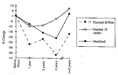
The graph in Figure 4, depicts the different
experiences of each flood
submarket following the 1986 event, and demonstrates that the flood did,
indeed, have an impact on sold prices that varied depending upon depth of
flooding. Properties flooded to more than 10 feet experienced a
significant, and immediate post-flood decline in sold prices, such that
even after one year, prices were almost 30% lower than pre-flood levels.
An increase by the end of the second year probably reflected investments
in repairs and the resale of houses (Montz and Tobin, 1988; Tobin and
Montz, 1988). But this did not last, as prices fell again over the next
two years only rebounding somewhat at the end of the 10-year period. In
contrast, the sold prices for houses flooded to 18 inches reproduced the
theoretical pattern presented by line B in Figure
1. Prices fell
immediately following the flood, but then gradually increased over time,
and ended the period with the highest proportional increase. Non-flooded
houses also experienced a post-flood decline, perhaps contrary to what
might be expected, although this may have reflected a general lack of
interest in the housing market of Linda and Olivehurst after such a
catastrophic event.
CONCLUSIONS - FURTHER RESEARCH
Evidence immediately following the 1997 floods suggests that there has
been an impact on the residential real estate market, primarily by
encouraging some individuals to move off the perceived floodplain. On the
other hand, the flood has also had a negative impact in those areas
flooded to the greatest depths, at least over the short term. The housing
market is virtually non-existent in this flood zone, a situation that is
comparable with the 1986 event. The president of the Board of Realtors
also feared that many businesses would relocate to "safer" areas while
others would not come to Yuba/Marysville area because of the publicity,
thus compounding the economic woes of the communities. This is a valid
point. News media had indicated that virtually all of Yuba City and/or
Marysville was under water at some time and in fact nearly all residents
in Marysville had been evacuated. Yet, no serious flooding occurred in
Yuba City or Marysville and only parts of Olivehurst were inundated.
Pre-flood values of houses affected by the 1997 floods indicate that,
overall, this is a somewhat more affluent area than the neighborhoods
flooded in 1986, even when the effects of the 1986 flood are taken into
account. Indeed, new residential development near the Plumas golf course
was planned before the levees broke, and existing housing in that area
tends to be larger and more expensive than houses elsewhere in the
communities. Whether or not these trends continue, with distinct
differences between flood zones, is the focus of continued research. Thus,
the 1997 floods open new opportunities for evaluating the longitudinal
effects of flooding and for comparing impacts among neighborhoods and
between flood events. Results from the long-term analysis of properties
flooded in 1986 suggest that differences between flooded areas will
continue. However, the properties flooded to the greatest depths in 1986
started out at the same value as those with lower flood depths. In 1997,
more expensive homes experienced the greatest depths. Their recovery may
differ from the 1986 experience as a result, perhaps facilitated by the
high pre-flood values. Research is continuing to track these trends.
A second avenue of research was raised by both the County Administrator
and the President of the Board of Realtors, who suggested the possibility
that psychological stress might accrue within the Yuba and Marysville
areas because faith in the levees had been severely compromised. It would
be worth tracking, therefore, (i) if this is indeed true; (ii) if true,
how long this perception persists; and (iii) whether this belief has any
impact on location/relocation choices regarding housing. It is probable,
for instance, that a proposed estate of 1200 houses will no longer be
built in the Olivehurst area.
Longevity of Impacts - the Recovery Period
From the data collected it was possible to track changes in property
values since the 1986 flood to set up longer term analyses of house prices
for the next few years. This should result in a better understanding of
the effects of flooding on the residential land market. Earlier research
showed that repairs to flooded properties may influence recovery such that
properties with greater flood depths would perhaps recover more quickly
because there were more extensive repairs and, thus, upgrading and
updating of houses (Tobin and Montz, 1994). This did not appear to be the
case, over the longer term. Properties that experienced flooding in 1986
did eventually recover to near pre-flood levels, but the length of time
that this recovery took varied with depth of flooding. When compared to
immediate post-flood values, houses with lower flood levels recovered more
quickly and exhibited a greater increase in sold prices. For houses
experiencing greater depths, the recovery period was in excess of 10
years, confirming that the flood had been capitalized into property values
in spite of the repairs.
Despite the once-in-a-lifetime nature of this flood, the spatial
variations in recovery demonstrated that the effects are long-lasting.
Indeed, the submarkets classified after the 1986 flood remained
identifiable over the long term. Part of this may be due to the fact that
not all properties in the areas with greatest flood depths were repaired.
For many years after the 1986 flood, some houses remained abandoned.
Certainly this has been a constant reminder of the flood for potential
buyers, in addition to the depreciating effect such properties can have on
surrounding property values. Hence, although the expectation of flooding
has probably been low, given the nature of the 1986 flood, the reminders
that exist in the communities influence recovery and this perpetuates the
submarkets. Of course, the 1997 events have further compounded the
situation and will provide another element to the longitudinal study of
these areas.
REFERENCES
-
Alesch, D.J. and Petak, W.J. 1986.
-
The Politics and Economics of
Earthquake Mitigation: Unreinforced Masonry Buildings in Southern
California. (Monograph 43) Program on Environment and Behavior:
Boulder, Colorado: Institute of Behavioral Science, University of
Colorado.
-
Babcock, M., and Mitchell, B. 1980.
-
Impact of Flood Hazard on Residential Property Values in Galt (Cambridge),
Ontario. Water Resources Bulletin 16(2):532-37.
-
Brookshire, D.S., Thayer, M.A., Tschirhart, J., and Schulze, W. D. 1985.
-
A Test of the Expected Utility Model: Evidence From Earthquake Risks.
Journal of Political Economy 92:369-89.
-
Burby, R.J., and French, S.P. 1981.
-
Coping with Floods: The Land Use Management Paradox. Journal of the
American Planning Association 47:289-300.
-
Changnon, S.A., Schicht, R.J., and Semonin R.G. 1983.
-
A Plan for Research on Floods and Their Mitigation in the United States.
In Final Report to National Science Foundation (NSF-PAG-81-17027).
-
California Department of Water Resources. 1997.
-
California Data Exchange Center.
http://cdec.water.ca.gov/.
-
Dunstan, J.C. 1997.
-
Personal Communication. County Administrator, County Administrators
Office, Yuba County.
-
Lambley, D.B. and Cordery, I. 1991.
-
Effects of Floods on Housing Markets in Sydney. In Proceedings of
International Hydrology and Water Resources Symposium, 1991, Perth,
Australia. pp. 863-866.
-
Leighton, L. 1997.
-
Personal Communication. President of the Yuba-Sutter Board of
Realtors, Yuba City, California.
-
MacDonald, D.N., Murdoch, J.C., and White, H.L. 1987.
-
Uncertain Hazards, Insurance and Consumer Choice: Evidence from Housing
Market. Land Economics 63:361-371.
- Montz, B.E. 1992.
- The Effects of Flooding on Residential
Property Values in Three New Zealand Communities. Applied
Geography 13(3): 225-242.
-
Montz, B.E. and Tobin, G.A. 1986.
-
Spatial and Temporal Variability in Residential Land Values Following
Catastrophic Flooding. Quick Response Reports, 17. Natural Hazards
Research and Applications Information Center, University of Colorado,
Boulder.
-
Montz, B.E. and Tobin, G.A. 1987
-
Real Estate Agents and Post Flood Recovery: Implications for Floodplain
Management. In Realistic Approaches to Better Floodplain
Management, The Association of State Floodplain Managers and Natural
Hazards Research and Applications Information Center, Special Publication,
No. 18, pp. 111-119. Boulder, Colorado.
-
Montz, B.E. and Tobin, G.A. (1988)
-
The Spatial and Temporal Variability of Residential Real Estate Values in
Response to Flooding. Disasters: The Journal of Disaster Studies and
Management Vol. 12, No. 4, pp. 345-355.
-
Montz, B.E. and Tobin, G.A. 1990.
-
The Impacts of Tropical Storm Agnes on Residential Property Values in
Wilkes-Barre Pennsylvania. The Pennsylvania Geographer 45(2): 336-341.
-
Muckleston, K.W., Turner, M.F., and Brainerd, R.T. 1981.
-
Floodplain Regulations and Residential Land Values in Oregon.
Office of Water Resources Technology (No. A-054-ORE) and Water Resources
Research Institute, Oregon State University, Corvallis, Oregon.
-
Palm, R. 1982.
-
Earthquake Hazards Information : The Experience of Mandated Disclosure. In
Geography and the Urban Environment: Progress in Research and
Applications, ed. D.T. Herbert and R.J. Johnston, 5:241-77.
Chichester: Wiley.
-
Scawthorn, C., Iemura, H., and Yamada, Y. 1982.
-
The Influence of Natural Hazards on Urban Housing Location. Journal of
Urban Economics 11:242-51.
-
Sheaffer, J.R., and Greenberg, L.S. 1981.
-
Evaluation of the Economic, Social and Environmental Effects of
Floodplain Regulations. U.S. Department of Housing and Urban
Development and Federal Emergency Management Agency, Washington, D.C.
-
Teets, B. and Young, S. 1986.
-
Rivers of Fear: The Great California Flood of 1986. Terra Alta,
WV: C.R. Publications, Inc.
-
Tobin, G.A. and Montz, B.E. (1988)
-
Catastrophic Flooding and The Response
of the Residential Real Estate Market. The Social Science Journal
Vol. 25, No. 2, pp. 167-177.
-
Tobin, G.A. and Montz, B.E. 1990.
-
Response of the Real Estate Market to Frequent Flooding: the Case of Des
Plaines, Illinois. Bulletin of the Illinois Geographical Society
23(2): 11-21.
-
Tobin, G.A. and Montz, B.E. (1994)
-
The Flood Hazard and Dynamics of the Residential Land Market. Water
Resources Bulletin, Vol. 30, No. 4, pp. 673-685.
-
Tobin, G.A. and Newton, T.G. (1986)
-
A Theoretical Framework of Flood Induced Changes in Urban Land Values.
Water Resources Bulletin Vol. 22, No. 1, pp. 67-71.
-
Vogel, N. 1997.
-
Ancient Levees Targeted. Sacramento Bee January 8.
http://www.sacbee.com/news/floods/.
-
Vogel, N., and J.D. Cox. 1997.
-
The Thin Weak Links of Flood Control. Sacramento Bee January 8.
http://www.sacbee.com/news/floods/.
-
Yezer, A.M., and Rubin, C.B. 1987.
-
The Local Economic Effects of Natural Disasters. Institute of
Behavioral Science Working Paper No. 61, Natural Hazard Research and
Applications Information Center, University of Colorado.
Tables
TABLE 1:  Comparison of House Sizes for 1986 and 1997 Flood
Zones

Flood Zone      <1,000 sq.ft. 1,000-1,300 sq.ft.  >1,300 sq. ft. Total

Flood Area '86     77  43%       67  38%              34  19%      78
Flood Area '97      6  13%       20  42%              22  46%      48
Total              83  37%       87  39%              56  25%     226
TABLE 2: Comparison of House List Prices - 1986 and 1997 Flood
Zones
Submarkets           N      Max $     Min $    Mean $    Median $

Rooftops '86        71     69,923    18,439    45,028     46,596
18 Inches '86       62     64,352    38,009    49,641     49,046
10 Feet '86         45     65,004    29,282    52,190     52,795
Not Flooded        108     77,900    19,437    51,026     51,916
< 2 Feet '97        13     67,760    34,001    53,939     57,212
2-4 Feet '97        17     87,940    31,922    63,073     59,193
> 4 Feet '97        18    196,416    40,706   103,548    103,503
(1984 $ values)
TABLE 3: Comparison of House Sold Prices - 1986 and 1997 Flood
Areas
Submarkets           N      Max $     Min $    Mean $    Median $
Rooftops '86        46     69,014    13,582    41,902     41,593
18 Inches '86       47     61,856    30,864    47,166     48,044
10 Feet '86         40     65,004    17,921    50,319     49,240
Not Flooded        101     77,000    16,124    48,133     48,728
< 2 Feet '97        12     66,129    33,619    51,809     56,588
2-4 Feet '97        15     86,086    22,727    62,935     59,416
> 4 Feet '97        17    193,662    33,921    96,833    100,200
(1984 $ values)
TABLE 4: Median House Sold Prices as a Function of Flood Zone
Flood/Non-Flood Zones  Median Sold Price  Total
 Flood Area '86            121      68%        57       32%      178
Non-Flooded                56      55%        45       45%      101
Flood Area '97             14      29%        34       71%       48
Total                         191                 136           327

X2 = 20.8, df = 2, p<.001
Figures
FIGURE 1
: Theoretical Framework Outlining the Potential Impact and
Subsequent Recovery of Land Values Following a Disasters.
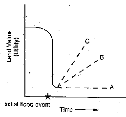
FIGURE 2
: Extent of Flooding in Linda and Olivehurst, California
in 1986.
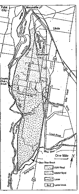
FIGURE 3
: Extent of Flooding in Linda and Olivehurst, California
in 1997.
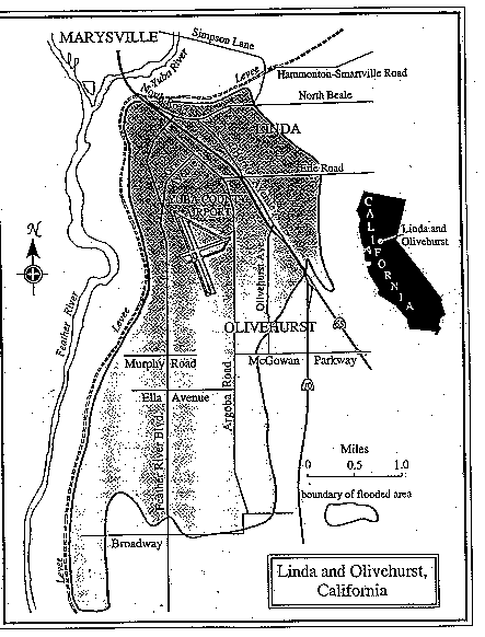
FIGURE 4
: Changes in House Sold Prices Following the 1986 Flood in
Linda and Olivehurst, California.
Return to Hazards Center Home Page
October 8, 1997
hazctr@colorado.edu