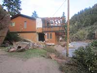
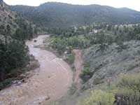
The 2013 Colorado Floods
Media Galleries
If you would like to contribute photos, video, or any other media related to the flood, please contact us at hazctr@colorado.edu More media will be added all the time, so check back!
Maps
- FEMA's Colorado Flood situational awareness viewer includes masses of information, from impact analysis to geotagged photos. Go to 'Contents' to toggle different information layers on/off.
- An Interactive Map of 'Untold Stories' From Readers from the Daily Camera is a collection of geotagged stories from citizens who were affected by the flood combined with pictures they sent in. An extremely valuable collection of first-hand accounts
- 2013 Flood Maps showing the inundation and damage in the City of Boulder
- 2013 Colorado Flooding Photo and Video Map from the Denver Post, featuring geotagged photos and videos from across the affected areas
- Before and After Photos from the Denver Post, a map with geotagged before-after comparison images
- DigitalGlobe aerial images of the Colorado Flood in Lyons and Longmont,satellite images showing flood damage in the stated areas
- Interactive before and after images from multiple regions of the flood from the Huffington Post
- Civil Air Patrol's Aerial Images for the 2013 Colorado floods contains 99 aerial geotagged images taken by the Civilian Air Patrol during the floods
- An interactive map from NOAA showing the 7 day precipitation totals between Sept 9th and Sept 15th
- Boulder County parks and open space flood damage tour, featuring photos detailing the damage and flood extent to open space areas across Boulder County.
- Longmont Flood Recovery Overview