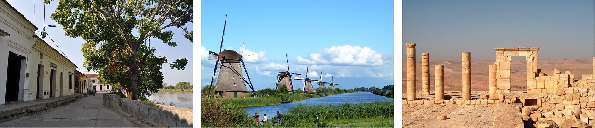
(Left to right) Fig. 1. Santa Cruz de Mompox, Colombia © Armando Calderón 2010. Founded in 1540 on the banks of the River Magdalena, Mompox played a key role in the Spanish colonization of northern South America. From the 16th to the 19th century the city developed parallel to the river with the main street acting as a dyke. The historic centre of Mompox became a UNESCO heritage site in 1995. Fig. 2. Kinderdijk, Netherlands © David van der Mark, 2015, The windmill pumping complex in Kinderdijk is situated in a polder at the confluence of two main rivers. To drain the polder, a system of 19 windmills was built around 1740. The group of mills has been a UNESCO World Heritage site since 1997. Fig. 3 Nabatean Cities Negev, Israel, Open Domain 2005. The four Nabatean towns of Haluza, Mamshit, Avdat and Shivta in the Negev Desert are situated on the Frankincense route from south Arabia to the Mediterranean, which flourished from the 3rd century BC until the 2nd century AD. These cities, a UNESCO site since 2005, are examples of the way the harsh desert was colonised for agriculture through the use of highly sophisticated irrigation systems.
IN AN ERA MARKED BY by a steady increase in climate-related natural disasters, we are forced to look in previously unexplored directions for effective adaptive responses to hazards. For example, in the past decade, Western scientists have begun to value the complementary role that traditional indigenous knowledge can play regarding adaptation and response strategies. Looking at past cultures for inspiration is an extension of this trend. Indeed, we can learn many lessons from the ways past cultures sought to prevent, avoid, and reduce hazards.
A valuable source to find some examples of how humans have adjusted to hazards is the United Nations Educational, Scientific and Cultural Organization (UNESCO) World Heritage List, which expresses humanity’s commitment to conserve places that we value above all others.
In 2014 there were 47 sites of hazard engagement on this list. Considering the fact that this is only a meager 5 percent of the total number of World Heritage sites, the list does not reflect the full range of how humans have adjusted to their environments. We must do more to facilitate the conservation of human responses to natural hazards and disasters.
The tale of such responses is worth telling because it demonstrates many successes. It also illuminates the dynamics of risk assessment and management in different habitats occupied by different cultures, by employing different cognitive routings, different mixes of coping measures, and different regimes of regulation. The history of how humans engage with natural hazards presents a diversity of experiences that we can exploit to achieve a better fit between society and nature in the decades ahead. Adjustment to hazard is not just a practical matter of ensuring the security of heritage sites; it has been, and will continue to be, one of the master tasks of civilization. Given this degree of salience in human affairs, it is instructive to examine how sites of human engagement with natural hazards are represented on the current World Heritage List.
These 47 sites illustrate adjustments made by individuals or groups to risks posed by extreme natural events. These adjustments include behavioral and material responses to risk. They include religious taboos, systems of formal record-keeping and inquiry, indigenous warning networks, site abandonments, relocation of high-value investments, institutional arrangements for mobilizing mass action during emergencies, as well as careful management of protective natural vegetation and landforms, hazard resistant folk housing, and structural engineering works.
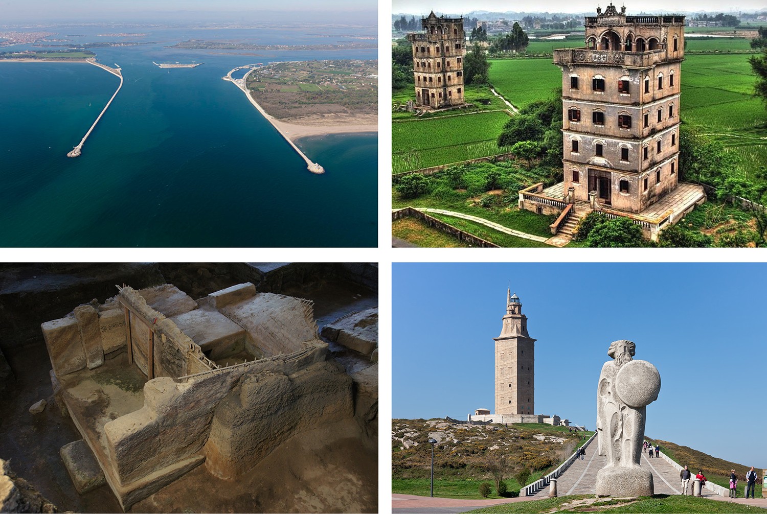
(Left to right) Fig. 4 Mose Barrier Project Venice, Italy Open Domain 2012. The MOSE project protects the city of Venice and the Venetian Lagoon from flooding. Its mobile flood gates temporarily isolate the lagoon from the Adriatic Sea during high tides. Venice and its lagoon have been a UNESCO World Heritage site since 1987. Fig 5. Kaiping Diaolou, China © ToisanHeritage, 2015. Kaiping Diaolou and Villages feature the Diaolou, multi-storey towers (built during the early Qing Dynasty in the 1920s and 1930s) used as watchtowers and temporary refuge during flood. The towers became a World Heritage Site in 2007. Fig. 6. Joya de Cerén, El Salvador, © Hectorlo, 2015. Joya de Cerén was a pre-Hispanic farming community that, like Pompeii and Herculaneum in Italy, was buried under an eruption of the Laguna Caldera Volcano c. AD 600. Underneath the layers of volcanic ash, 18 structures were identified. Rammed earth construction was used for the public buildings and the sauna, and wattle and daub (which is highly earthquake resistant) for household structures. Joya de Cerén became a UNESCO Heritage site in 1993. Fig. 7. Tower of Hercules, Coruña, Spain, Open Domain 2011. The Tower of Hercules is an ancient Roman lighthouse on a peninsula just outside of Coruña. The tower, a UNESCO Heritage site since 2009, is the oldest existing lighthouse in the world and is a prime example of a seismic-resistant construction.
Most sites of human engagement with hazards focus on earthquakes and floods. Storms and droughts, two other hazards that have had great cultural importance (Perez, 2000; Mulcachy 2008; Hoffman and Smith, 2002), have received far less attention. They account for 10 percent and 6 percent, respectively, of the hazard-engagement sites. The remaining 16 percent provide limited information about adjustments to volcanoes (10 percent), frost (2 percent), landslides (2 percent) and erosion (2 percent). It is not clear why earthquakes and floods are showcased as culturally significant hazards. One possibility is the central role they have played in creation and rejuvenation myths of previous civilizations. Certainly these hazards can comprehensively demolish or sweep away buildings and smother cultivated lands, thereby obliterating existing signs of human endeavor and rendering fruitless previous efforts to inscribe our presence on the landscape—a particularly unsettling prospect for organizations that wish to preserve evidence of human agency.
While it is vital that more sites of human engagement with hazards are recognized for their educational value and added to the List, several plausible explanations exist for the current underrepresentation of such sites.
Firstly, it is important to consider that adjustments to hazards can continuously reconfigure landscapes (e.g., several sites in the Netherlands), thereby making it difficult to identify those that meet the test of authenticity, an important criterion in the Heritage Site designation process. (Schoorl 2005). Secondly, natural disasters have long had a disproportionate impact on poor and marginalized communities, not groups that have had power to imprint their identities on larger cultural landscapes (Morgan and Barrett 2006). Finally, it should be noted that there is tension between nominations that members of state interest groups make and those made by expert interest groups in the heritage site nomination process. As Meskell (2013) notes, technical advice offered by scientific experts has often been rejected or circumvented by state (i.e., national government) representatives in World Heritage Site decision-making bodies. Rössler (2006) remarked: “With rare exceptions, for the most part inscribed in the past five years, the World Heritage List is skewed and unrepresentative of the totality—and hence the universality—of human cultural development and achievement.”
None of these issues poses insurmountable problems for the selection of more World Heritage sites of hazard engagement. Indeed, such sites are usually excellent examples of the conditional nature of how humans choose to engage with environmental uncertainties. Their authenticity is time-related and reflective of the negotiated choices made by different groups that have a stake in the outcomes at different times. More inclusive decision-making processes easily help avoid underrepresentation of sites that are meaningful to poor or underprivileged groups. Getting state officials and scientists to agree on site choices may be a more persistent challenge, but one that can be resolved by having clear rules about procedures for resolving disagreements.
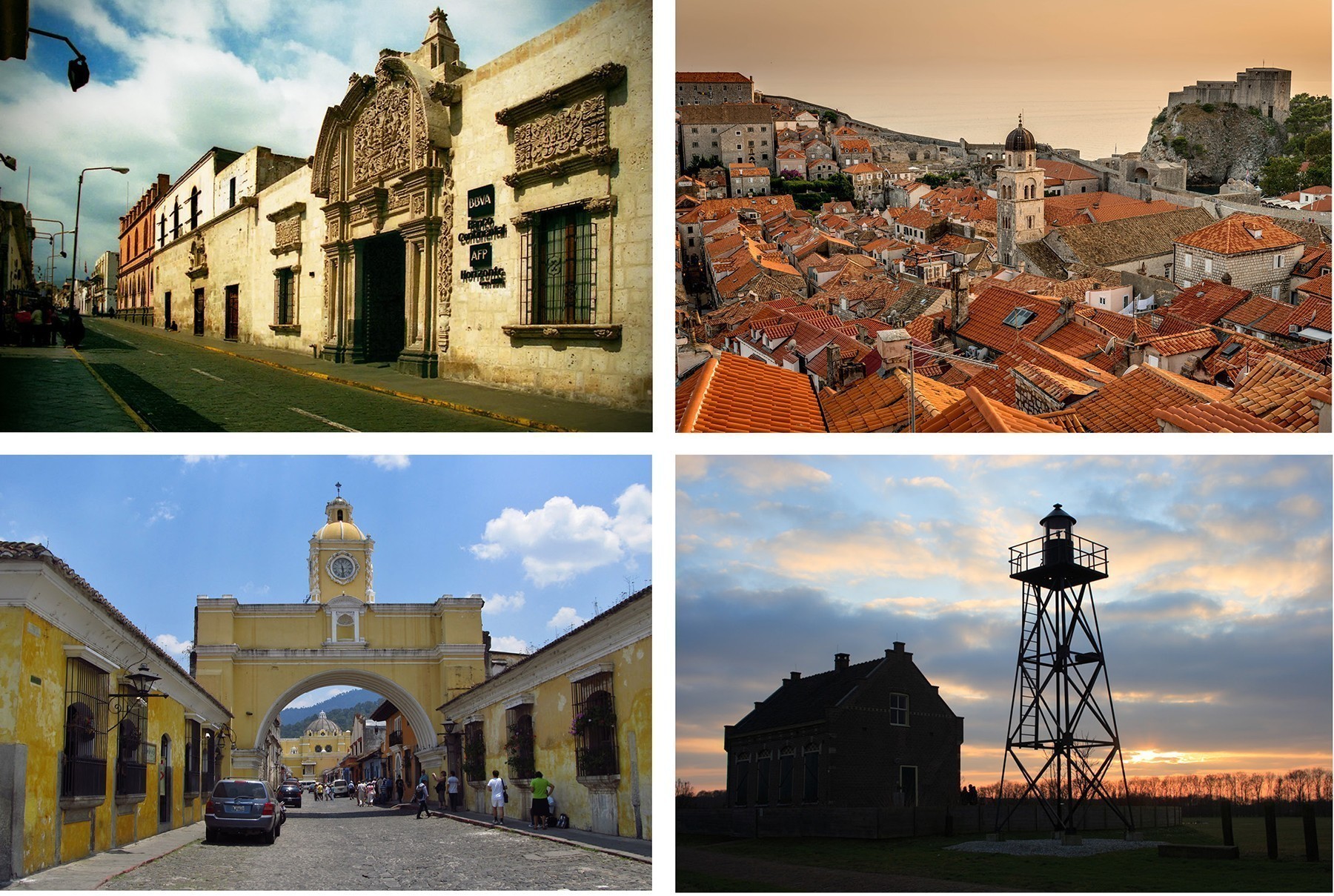
(Left to right) Fig. 8. Arequipa, Peru © Martin Garcia 2010. The historical center of Arequipa became a UNESCO Heritage site in 2000. Located at the foot of three volcanoes, Arequipa was founded in 1540. Despite numerous natural catastrophes, including several major earthquakes, most buildings in the historical center of the city have been repaired many times and rebuilt to endure the geographic environment without losing their typology or their ornamental characteristics. Fig. 9. Dubrovnik, Croatia © Marcus Saul 2013, Dubrovnik, the ‘Pearl of the Adriatic’, situated on the Dalmatian coast, became an important Mediterranean sea power from the 13th century onwards. Although severely damaged by an earthquake in 1667, Dubrovnik managed to preserve its beautiful Gothic, Renaissance and Baroque churches, monasteries, palaces and fountains. The city’s historic center became a UNESCO Heritage site in 1979. Fig. 10. Antigua, Guatemala © Jasperdo, 2012. Built 1,530.17 m above sea level in an earthquake-prone region, Antigua Guatemala was founded in 1524 as Santiago de Guatemala. It was subsequently destroyed by fire caused by an uprising of the indigenous population, re-established in 1527 and entirely buried as a result of earthquakes and an avalanche in 1541. The third location, in the Valley of Panchoy or Pacán, was inaugurated in March 1543 and served for 230 years. It survived natural disasters of floods, volcanic eruptions and other serious tremors until 1773 when the Santa Marta earthquakes destroyed much of the town. At this point, authorities ordered the relocation of the capital to a safer location region, which became Guatemala City, the county’s modern capital. Some residents stayed behind in the original town (see picture) which became referred to as “La Antigua Guatemala”. Fig. 11. Schokland, The Netherlands, © Jayjay 2009. Schokland was a peninsula that by the 15th century had become an island. Occupied and then abandoned as the sea encroached, it had to be evacuated in 1859. However, following the draining of the Zuider Zee in the 1920s, it has formed part of the land reclaimed from the sea. Schokland has vestiges of human habitation going back to prehistoric times. It symbolizes the heroic, age-old struggle of the people of the Netherlands against the encroachment of the waters. The remains of dykes and terps located outside the present island reflect the former contours of the island and the land that has been lost over the course of time. Also located outside the present island, but within the boundaries of the World Heritage property, are more than 160 archaeological sites with remnants of prehistoric occupation. A church and church ruins, residential and commercial buildings, barns, a former harbour, and land division patterns (both old and new) go to complete the story of Schokland.
From Homo Faber to Homo Cognito
When we further examine the sites of human engagement with hazards, it is remarkable that engineering measures dominate the portrayal of hazard adjustments. Those measures most often come in the form of flood and drought- reduction devices, such as walls, gates, dikes, terraces, cisterns and canals as well as disaster-resistant buildings. Human agency is in the hands of Homo Faber, a technology-wielding species intent on controlling hostile physical environments. Just over two-thirds of the sites feature some type of structural engineering response to risk. Examples of protective structures include: the flood barricades of Mompox, Colombia; the Kinderdijk windmill pumping complex in the Netherlands; the flash-flood harvesting system of Nabatean cities in the Negev region of Israel; and the as-yet-uncompleted MOSE moveable barrier project that is intended to protect Venice against aqua alta from the Adriatic Sea. Specific types of hazard-resistant buildings are exemplified by the following constructs: flood refuge towers (Kaiping Diaolou, China), earthquake resistant wattle and daub housing (Joya de Ceren, El Salvador), and other kinds of earthquake-adapted structures (Oaxaca, Mexico). Many larger urban settlements, especially in Latin America, were also extensively reconstructed in the wake of a disaster, with a view to making them resistant to future extreme events (e.g. Ariquipa, Peru; Dubrovnik, Croatia; Lima, Peru; Quito, Ecuador; Valpariso, Chile).
A second, but much smaller, group of hazard engagement sites involves nonstructural adaptations that rely on informing humans about risks and acting in receipt of that knowledge (27 percent). Some of these places are distinguished by the richness of the historic record of hazard events that can be found there, or by the opportunities they afford for scientific study of ongoing risk processes and the development of public warning systems (e.g. Mount Etna, Italy; Hawaii Volcanoes National Park, USA). Other sites show: judicious selection of risk-minimizing locations for buildings and settlements; warning and evacuation in the face of acute threats; and abandonment and permanent relocation to safer places. Additionally, they illustrate ways to accommodate extreme natural processes rather than try to control them. For example, residents of coastal communities in the Ganges-Bhramaputra Delta (Sundarbans of India and Bangladesh) and the sandy shores of the southern Baltic Sea (Curonian Spit, Lithuania/Russia) both owe their survival to stewardship of vegetative shelterbelts and barrier islands that have protected fishing and farming communities. Examples include flood markers of the Loire valley in France, flood refuge mounds of Djenne, Mali; storm-sensitive sites on which the churches of Chiloe, Chile, were founded; earthquake-relocated buildings of Antigua, Guatemala; and the twice-relocated village of cyclone-plagued Le Morne, Mauritius. All of these provide vivid examples of how humans can learn from and adjust to acute environmental perturbations without having to construct large-scale “hard” engineering measures.
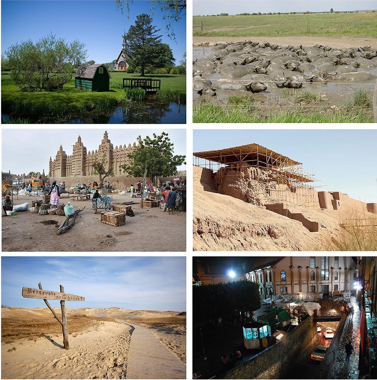
(Left to right) Fig. 12. Grand Pré, Canada © Charles Hoffman, 2009. Situated in the southern Minas Basin of Nova Scotia, the Grand Pré marshland and archaeological sites constitute a cultural landscape bearing testimony to the development of agricultural farmland using dykes and the aboiteau wooden sluice system, started by the Acadians in the 17th century and further developed and maintained by the Planters and present-day inhabitants. Grand Pré has been a UNESCO World Heritage site since 2012. Fig. 13. Hortobágy Puszta, Hungary © Gerdragon, 2005. The cultural landscape of the Hortobágy Puszta consists of a vast area of plains and wetlands in eastern Hungary. Traditional forms of land use, such as the grazing of domestic animals, have been present in this pastoral society for more than two millennia. From the middle 19th century, water regulation systems were set up to control flooding of the Tisza River. This resulted in the partial draining of former wetlands, which were converted to grasslands or arable farming. Hortobágy Puszta was added to the World Heritage list in 1999. Fig. 14. Djenné, Mali © Devriese 2003. Inhabited since 250 BC, Djenné became a market centre and an important link in the trans-Saharan gold trade. Its traditional houses, of which nearly 2,000 have survived, are built on hillocks (toguere) as protection from the seasonal floods. Djenné together with Djenné-Djeno were designated a World Heritage Site by UNESCO in 1988. Fig. 15. Bam, Iran © OXLAEY 2014. Bam is situated in a desert environment on the southern edge of the Iranian high plateau. The origins of Bam can be traced back to the Achaemenid period (6th to 4th centuries BC). The existence of life in the oasis was based on the underground irrigation canals, the qanāts, of which Bam has preserved some of the earliest evidence in Iran. The 2003 earthquake caused the collapse of various sections of the Governor’s Quarters and the upper parts of the defence walls. Notwithstanding, much of the lost fabric was from modern restorations. The materials found at the older levels are well preserved and have now been revealed. Fig. 16. Curonian Spit, Lithuania/Russia © Kontis Šatūnas, 2008. Human habitation of this elongated sand dune peninsula dates back to prehistoric times. Throughout this period it has been threatened by the natural forces of wind and waves. Its survival to the present day has been made possible only as a result of ceaseless human efforts to combat the erosion of the Spit, dramatically illustrated by continuing stabilisation and reforestation projects. Fig. 17. Flood diversion tunnels, Guanajuato, Mexico © AlejandroLinaresGarcia, 2010. To reduce persistent flooding of this 16th century city that was founded by the Spanish, officials decided to blast river diversion tunnels under the city’s hilly setting in the early 19th century. When a dam eventually sent the river around the city, it found itself blessed with a system of low, dry tunnels into which it poured its surplus traffic instead.
Finally, humans engage the spiritual dimensions of natural hazards at a small number of sites (5 percent)—most notably Tongariro National Park in New Zealand and Mount Fuji in Japan, but also Hawaii Volcanoes National Park in the United States. These are places of high religious salience for indigenous cultures and are also at risk to active volcanism. Sometimes the existence of religious taboos has served to discourage human settlements from locations near the volcanoes, thereby serving to reduce risk. Donovan (2010) provides a discussion of similar beliefs of people living near Indonesia’s Mount Merapi.
The heavy emphasis on structural engineering and building modifications as preferred adjustments mirrors a long-running bias that many human cultures have held, especially in the West, toward technological fixes for hazards. Though the value of these fixes has often been considerable, they have also been criticized for failing to live up to expectations and for lulling humans into believing that they are protected against all future events instead of just the subset of events that fall within design specifications. The prioritizing of engineering technologies as hazard- management tools reflects both a characterization of nature as separate from humanity, and of disasters as outcomes of natural risks that are inflicted on unfortunate humans who bear little or no responsibility for their creation.
This view has weakened considerably in recent decades as scientists, most prominently the geographer Gilbert White (Hinshaw 2006), have revised notions of causation to include a greater role for human agency (Mileti 1999; MacDonald et al 2012). Disasters are now widely regarded as joint products of natural risks and human vulnerabilities. Further, the human contribution to disasters is not simply a function of decisions about exposure and protection that render us more or less likely to suffer loss. We humans are also expanding our capacity to change processes that generate environmental risks. The apotheosis of this discourse is human-caused climate change, a phenomenon now accepted by the bulk of the world’s scientific community.
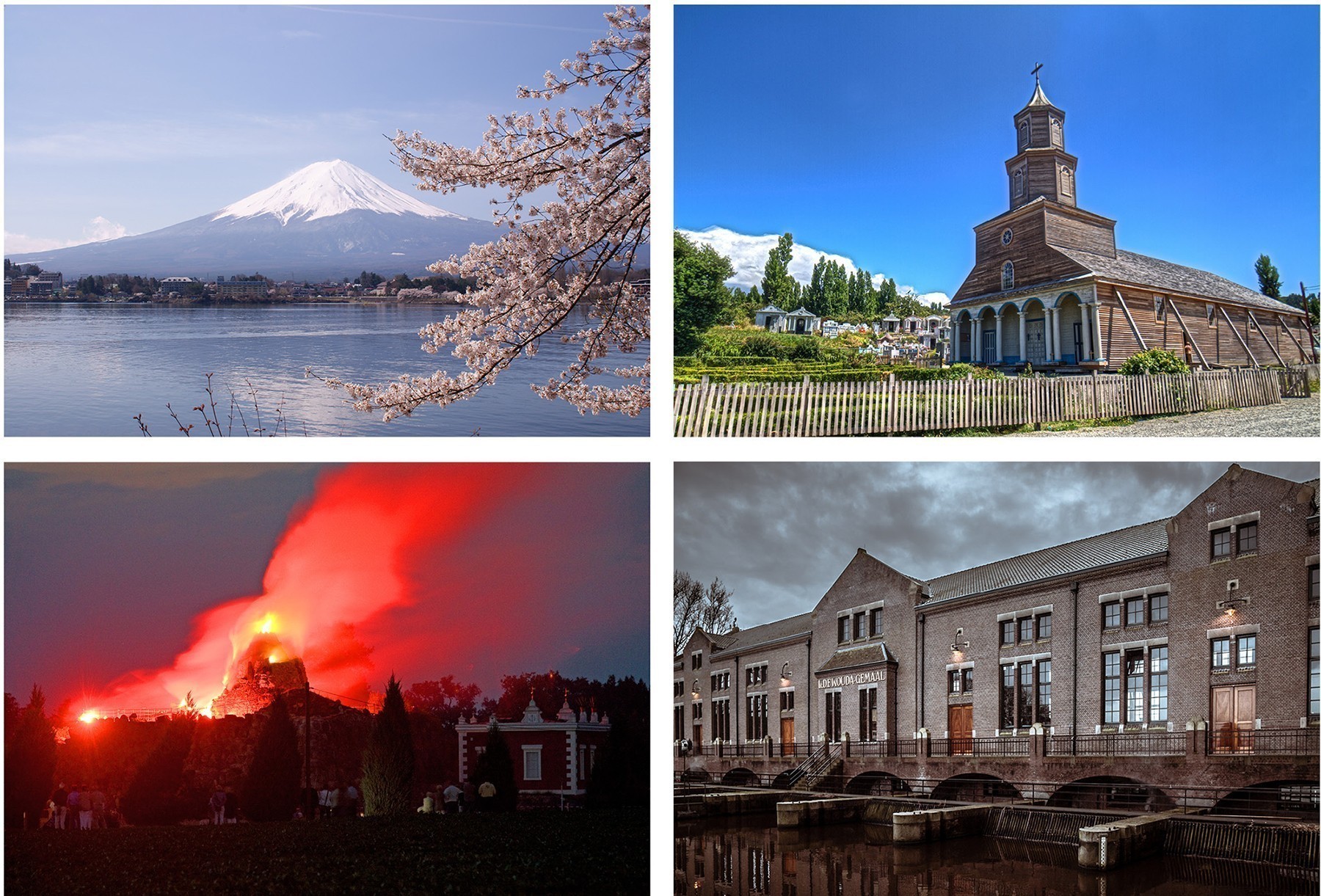
Fig. 18. Mount Fuji © Midori, 2010. The beauty of the solitary, often snow-capped, stratovolcano, known around the world as Mount Fuji, rising above villages and tree-fringed sea and lakes has long been the object of pilgrimages and inspired artists and poets. The inscribed property (added to the UNESCO list in 2013) consists of 25 sites which reflect the essence of Fujisan’s sacred and artistic landscape. Fig. 19. The Churches of Chiloé, Chile © Srikanth Jandhyala, 2014. The Churches of Chiloé in Chile’s Chiloé Archipelago, built in the 18th and 19th centuries, were constructed entirely of native timber with extensive use of wood shingles. The materials were chosen because they are known to resist the Archipelago’s humid and rainy oceanic climate. In total 16 churches were designated UNESCO World Heritage sites in 2000. Fig. 20. Dessau-Worlitz Gardens, Germany, © H.-U. Küenle, 2010. The Garden Kingdom of Dessau-Wörlitz is an exceptional example of landscape design and planning of the Age of the Enlightenment (18th century). An island on the artificial Wörlitz Lake features Europe’s only artificial volcano. When Leopold III went on a grand tour of Europe in the 1760s, he was captivated by the smoldering Mount Vesuvius when he was in Naples and the newly discovered town of Pompeii. Twenty-two years later, the German royal set about bringing a piece of Naples to Germany; he had his architect build a brick inner building nearly five stories high and cover it with local boulders. At the top, a hollow cone was made and contained a high chamber, complete with three fireplaces and a roof that contained an “artificial crater” that could be filled with water. He then constructed a lake around the volcano and invited his friends to watch an eruption. The gardens became a UNESCO site in 2000. Fig. 21. Ir. D.F. Woudagemaal, Lemmer, The Netherlands © Uberprutser, 2012 The Ir. (engineer) D.F. Woudagemaal, opened in 1920 by Queen Wilhelmina, is the largest still operational steam-powered pumping station in the world. It was built to pump excess water out of Friesland, a province in the north of the Netherlands.
An expansive interpretation of human agency has helped to broaden the range of risk-reduction measures that are available for use. Public policies are shifted away from a dominant emphasis on technological fixes toward a mix of adjustments that adds many anticipatory measures and non-structural alternatives. These include risk education and information systems, conservations of ecosystems and environments that provide risk-reduction services, social networks that mobilize grassroots capacities for action and increase human resilience, hazard-sensitive land-use regulations, and insurance schemes that incorporate risk-reduction features (e.g. Grunfest 2000; Wood et al. 2012). These alternatives have the advantage of treading more lightly on the physical environment, reducing levels of exposure to loss, redressing inequities in the burden of hazard, mobilizing at-risk populations to act in their own defense, and offering prospects of greater resilience and sustainability in the long term—all objectives that are difficult to achieve by structures and reactive means alone.
Almost all the above measures have antecedents or analogs in previous eras. Some are more emergent, ephemeral or transitional, while others more long-lasting. Some are more rigid, while others more flexible. Some may require the skills of experts and high technology, but others are reliant on the mobilization of grassroots social capital. Differences in risks and sites as well as differences in populations and the choices they are willing to entertain existed in the past, creating a dynamic human ecology of hazard. In seeking to conjugate human responses to contemporary environmental hazards, policymakers and environmental managers face a diverse and ever-growing set of alternatives that they could adopt.
Insofar as many of these neglected measures often leave slight traces on the landscape, it is imperative that discussions of their importance be inserted into educational materials that explain World Heritage Sites—both those that are threatened by natural risks and those that illustrate human coping with risks. For example, in China and Japan vast efforts were devoted to protect structures against fires both natural and man-made, not just by placing fire-fighting resources in strategic locations (as in the Forbidden City, a UNESCO site since 1987), but through social organizations of neighborhood volunteers with designated duties as fire watchers and fighters. The superstructure of hazard-susceptible buildings was, in effect, sustained by many formal and informal, non-structural, social and other human-centered means—means that presently get short shrift in informational programs associated with existing Heritage Sites.
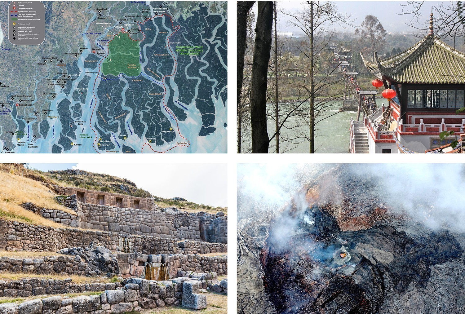
(Left to right) Fig. 22. Sundarbans, India/Bangladesh Open Domain 2008. The Sundarbans mangroveforest lies on the delta of the Ganges, Brhamaputra and Mghna rivers on the Bay of Bengal. The site is a complex network of tidal waterways, mudflats and small islands of salt tolerant mangrove forests. The Sundarbans provides sustainable livelihoods for millions of people in the vicinity of the site and acts as a shelter belt to protect the people from storms, cyclones, tidal surges, sea water seepage, and intrusion. The area has been a UNESCO site since 1987. Fig. 23. Dujiangyan, China, © Keso S. 2012. The construction of the Dujiangyan irrigation system began in the 3rd century BC. This system still controls the waters of the Minjiang River and distributes it to the fertile farmland of the Chengdu plains. In 2000, Dujiangyan became a UNESCO World Heritage Site. Fig. 24. Tambomachay, Cuzco Peru. © Diego Delso. Situated in the Peruvian Andes, Cuzco developed, under the Inca ruler Pachacutec, into a complex urban centre with distinct religious and administrative functions. It was surrounded by clearly delineated areas for agricultural, artisan and industrial production. Tampu Mach’ay (see image) is an archeological site consisting of a series of aqueducts, canals, and waterfalls that run trhough the terraced rocks. The city of Cuzco became a UNESCO World Heritage site in 1983. Fig. 25. Hawaii Volcanoes National Park, Kilauea © Neal Wellons, 2015. Two active volcanoes on the Big Island of Hawaii, Mauna Loa and Kilauea, are located within Hawaii Volcanoes National Park. These volcanoes were and still are sacred to the Ancient Hawaiians, who would travel to their summits to make offerings during eruptions. Kilauea is the home of the volcano goddess Pele. As the most active, non-explosive volcano in the world Kilauea is also of great interest to volcanologists. The park became a UNESCO site in 1987 and is a unique example of significant island building through ongoing volcanic processes. It represents the most recent activity in the continuing process of the geologic origin and change of the Hawaiian Archipelago.
Celebrating a more complete cultural heritage
Humans create the vulnerabilities that natural risks exploit. Likewise, the ability of humans to carve out “livability niches” in uncompromising or hostile environments has not only shaped many of the world’s landscapes in distinctive ways but also has conferred valuable lessons about our capacity for adaptation in the face of uncertain future risks. It is, therefore, sign of intellectual progress that the human role in shaping hazard is now recognized in programs of cultural heritage conservation, such as the World Heritage List. Further, it is also a sign of progress that human adjustments to hazard receive equal billing with other kinds of cultural achievements.
It is high time that the gaps on the World Heritage Site List discussed in this article are closed. Only then can we celebrate a more complete cultural heritage, one that could serve as a stimulus to improve how humans manage hazards.

Fig. 26. Forbidden City, China, © See-ming Lee, 2014. Copper and iron vats were part of the fire-fighting equipment in the Chinese Imperial palace. They were filled with water to be used to douse fires. From October to February every year, the vats were covered with quilts to prevent water freezing, and on very cold days they would be heated by charcoal fires. The oldest vats were cast during the Hongzhi reign period (1488-1505) of the Ming Dynasty. Each of the Ming Dynasty vats has two simple iron rings. The Qing Dynasty vats (pictured) have two beast-shaped bronze rings, a big belly and a small mouth. The Palace has a total of 308 copper and iron vats of various sizes.
Note: All captions were written by Elke Weesjes based on the UNESCO World Heritage Site website: http://www.unesco.org.
REFERENCES
Donovan. Katherine. 2010. “Doing social volcanology: Exploring a volcanic culture in Indonesia,” Area 42(1): 117-126.
Grunfest, E. 2000. “Non-structural mitigation of flood hazards” in Inland Flood Hazards: Human, Riparian and Aquatic communities. Ed. By Ellen E. Wohl, Cambridge University Press, 394-410.
Hinshaw, Robert E. 2006. Living with nature’s extremes: The life of Gilbert Fowler White. Boulder, CO: Johnson Books.
Hoffman, Susanna A. and Anthony Oliver-Smith. 2002. Catastrophe & culture: The anthropology of disaster. Santa Fe: School of American Research Press.
Macdonald, N.; Chester, D.; Sangster, H.; Todd, B.; Hooke, J.. 2012. “The significance of Gilbert F. White’s 1945 paper ‘Human adjustment to floods’ in the development of risk and hazard management,” Progress in Physical Geography, 3 (1): 125-134
Meskell, Lynn. 2013. “UNESCO’s World Heritage Convention at 40: Challenging the economic and political order of international heritage conservation,” Current Anthropology. 54 (4) 483-494.
Mileti, Dennis S. Ed. 1999. Disasters by Design: A reassessment of Natural Hazards in the United States. Washington, D.C.: John Henry Press
Morgan, David W., Nancy I. M. Morgan and Brenda Barrett. 2006. “Finding A Place For The Commonplace: Hurricane Katrina, Communities, And Preservation Law,” American Anthropologist, 108(4): 706-718
Mulcachy, Matthew. 2008. Hurricanes and Society in the British Greater Caribbean 1624-1783. Baltimore: Johns Hopkins University Press.
Perez, Louis A. 2000. Winds of change: Hurricanes and the transformation of Nineteenth century Cuba. Chapel Hill: University of North Carolina Press.
Rossler, Mechtild. 2006. “World Heritage Cultural Landscapes: A UNESCO Flagship Programme 1992-2006,” Landscape Research 31(4): 333-353.
Schoorl, F. F. J. 2005. “On authenticity and artificiality in heritage policies in the Netherlands,” Museum International No. 227, 57 (3): 79-85.
Wood, Matthew, Daniel Kovacs, Ann Bostrom, Todd Bridges and Igor Linkov. 2012.
“Flood risk management: US Army Corps of Engineers and Layperson Perceptions,” Risk Analysis 32 (8): 1349-1368.
James (Ken) Mitchell is professor emeritus, Department of Geography, School of Arts and Sciences, Rutgers University. Mitchell holds degrees from the University of Chicago (PhD), the University of Cincinnati (MA; MCP) and the Queens University of Belfast (BSc Hons). Before retiring in January 2016 he had completed 45 years of service at Rutgers, conducted field research on human dimensions of natural hazards in North America, Europe, East Asia and Australia, and authored more than 140 professional publications.
Mitchell has chaired the National Academy of Science ad hoc committee on the International Decade for Natural Disaster Reduction and the International Geographical Union Study Group on the Disaster Vulnerability of Megacities. He is a fellow of the American Academy for the Advancement of Science, a member of the International Research Committee on Disasters, and founder of the international journals Global Environmental Change and Environmental Hazards.
Recent publications include an assessment of risk governance in the world's largest cities; an advocacy piece on an expanded role for natural hazards education in UNESCO's World Heritage site program; and papers on local recovery from Super Storm Sandy and the co-production of storm surge risk information. He is currently completing a project supported by the Robert Wood Johnson Foundation and the Pew Charitable Trusts that explores the utility of Health Impact Assessment in the process of post-disaster recovery and preparing a paper on ways to grow the hazards constituency.