The Traditional Ecological Knowledge and Mitigation Nexus
The Pamunkey Indian Reservation
Publication Date: 2021
Abstract
Land use change since colonial times, recent sprawl, and sea level rise have caused extensive changes in Chesapeake Bay tributary streams, such as the Pamunkey River, on which the Pamunkey Indian Reservation is located. This pilot study assesses the human-water relationship of the Pamunkey Indian Tribe using GIS in a participatory research process. Our objectives were three-fold: (1) assess how sea level rise has and will alter the Pamunkey Indian Tribe’s human-water relationship, (2) spatially reference mitigation and adaption priorities, and (3) identify the role of traditional ecological knowledge in flood management. Flooding has altered access to culturally relevant livelihoods and the capacity to preserve artifacts on the reservation. Sea level rise maps helped identify homes and heritage sites along the shorelines and accessible roadways as top priorities, but extended priorities encompassed the whole reservation to ensure residential and community access and preserve undiscovered artifacts and graves. Proposed solutions ranged from extending bulkheads and living shorelines to restoring traditional management practices. Additional information and training about flood risk and prevention is of interest to reduce stress and increase planning capacity within the community. Federal technical and financial assistance is necessary to implement mitigation and adaptation activities. The support of the tribal council and chief and coordination with private land holders across and adjacent to the reservation is also required. Findings could inform resilience-building strategies for other coastal tribes and integration of tribal input into planning efforts.
Introduction
Traditional Ecological Knowledge and Hazards Planning
Site-specific traditional ecological knowledge of flooding, bank erosion, natural adaptation, and structural mitigation provides insight into the broader impact of sea level rise on the human-water interactions of coastal tribes. Traditional ecological knowledge is a set of culturally relevant practices and beliefs about human interactions with the environment that are developed through experience and observation. It is passed down by local stakeholders from generation to generation and reflects adaptations to changing conditions (Bethel et al., 20141). This historic knowledge is under-represented in mitigation and adaptation planning outside of reservations. For example, there are no specific guidelines for the Pamunkey Indian Tribe in the Middle Peninsula Planning District All-Hazards Mitigation Plan. It notes that there is an important fish hatchery on the Pamunkey Indian Reservation but only provides implementation instructions to the county (MPPDC, 20162). Integrating the traditional ecological knowledge of coastal communities with geospatial data decreases communication gaps between scientists and local communities (Bethel et al., 20113).
Sea Level Rise and Coastal Resilience
Land use change since colonial times, recent sprawl accompanied by water resource development, and sea level rise have caused extensive changes in the tributary streams of the Chesapeake Bay, such as the Pamunkey River, on which the Pamunkey Indian Reservation is located (Spivey, 20174). Coastal Virginia has a predicted sea level rise of between 1.9 to 11.5 feet at the mouth of the Chesapeake Bay within the next 100 years (Kleinosky et al., 20075). With two feet of sea level rise, much of the Pamunkey Indian Reservation would be submerged (Virginia Department of Environmental Quality, 20196). Sea level rise results in the negative effect of shoreline loss—including the short-term effects of high-water levels from hurricanes with a sustained offshore presence and the long-term effects of tidal flooding—that impacts the Chesapeake Bay area (Ezer, 20187). Shifting the focus of coastal development to resilience, “the ability of […] entire social ecological systems […] to withstand severe conditions and absorb shocks” (Weichselgartner & Kelman, 2015 p. 2518), is critical since rural communities, especially the Pamunkey Indian Reservation, face extreme risks from sea level rise. Without proactive adaptation and mitigation, the degradation of shoreline and coastal resources contribute to the loss of cultural assets, limit socio-economic opportunities, and increase vulnerability to hazards (Titus et al., 20099; Yin & Goddard, 201310). The coupled human-water system, which links communities culturally and economically with coastal resources, must be considered as flooding becomes more frequent and mitigation options are weighed (Baldassarre et al., 201311).
Mitigation and Adaptation
Two primary infrastructure options are available—grey and green. While both green and grey infrastructure require maintenance, retreat offers an option with reduced future risk and labor requirements. On the one hand, once property is bought and remediated, environmental processes can take over. On the other hand, pairing retreat with green or grey infrastructure would offer additional protections and median cost-benefits. However, without engagement in dialogue about the risks of sea level rise, individuals are less likely to implement either type of measure (Siegrist & Gutscher, 200812).
Grey infrastructure is the most commonly used by property owners, including local governments, to defend shorelines, partially due to contractor familiarity and existing neighboring structures. Grey solutions include flood gates, dikes, canals, levees, and sea walls that may damage ecosystems, limit the capacity to implement alternative solutions, and create a sense of false security amongst residents (Schäffler & Swilling, 201313; Hutton et al., 201814). Green solutions, such as living shorelines, help to achieve a dual objective: protect against erosion and restore coastal ecosystems (Dietz, 200715; Bilkovic et al., 201616; Toft et al., 201317; O’Donnell, 201618). The National Oceanic and Atmospheric Administration (NOAA) defines living shorelines as “vegetation or other living, natural ‘soft’ elements alone or in combination with some type of harder shoreline structure” (NOAA, 201519). The implementation of green solutions is lagging in the United States (Sutton-Grier et al., 201820). Using traditional ecological knowledge to identify appropriate mitigation and adaptation options could increase the implementation of pairing green infrastructure projects and retreat, which would stabilize shorelines and allow for traditional socio-economic uses while cultural assets and suitable alternative locations are secured.
Research Questions
This pilot study assessed the human-water relationship of the Pamunkey Indian Tribe with the Pamunkey River using GIS in a participatory process to prioritize sea level rise adaptation and mitigation strategies for the Pamunkey Indian Reservation. We posed two research questions:
What are the existing effects of sea level rise on the relationship between the Pamunkey Indian Tribe and the Pamunkey River?
What is the role of GIS visualizations and traditional ecological knowledge in setting adaptation and mitigation priorities?
This work addressed habitats and infrastructure critical to the Pamunkey Indian Tribe’s economy and heritage. Results will provide a historical record of the Pamunkey Indian Tribe’s human-water relationship and identify a range of adaptation and mitigation options that integrate traditional ecological knowledge.
Methods
Coastal Adaptation Survey
From July to September 2020, researchers at Old Dominion University conducted a survey of tribal members with traditional ecological knowledge of the Pamunkey River and reservation. Out of approximately 30 households residing on the reservation, 10-15 traditional ecological knowledge holders were identified by a representative of the Pamunkey Indian Tribal Resource Center. Printed surveys, including the four-part questionnaire (see Appendix 1 for more information), a printed 11X17-inch map of the associated web app with examples of priorities set when living shorelines were installed to protect the boat ramp and fishing huts from erosion (Strickland et al., 201921), and sample resilience matrices were delivered by the representative to eleven possible participants. Surveys could be completed on paper, electronically, or via phone. Responses were input into Qualtrics and the web app either by the participants or researchers. Nine surveys were returned. Responses were qualitatively and spatially analyzed. Questionnaires were manually coded and themed using the Resilience Matrix (Allen et al., 201822) and terms related to traditional ecological knowledge both from the literature and from what emerged from the surveys. Descriptive quotes were included to further explore the participant’s concerns and relationships between solutions and traditional practices. The Resilience Matrix was developed in coastal South Carolina and North Carolina and aligns physical resources and collective agency with sea level rise risk to identify adaptation priorities (Allen et al., 2018). Using the Resilience Matrix with GIS visualizations of sea level rise allows for community-based development of place-based solutions.
Pamunkey Coastal Adaptation Survey Application
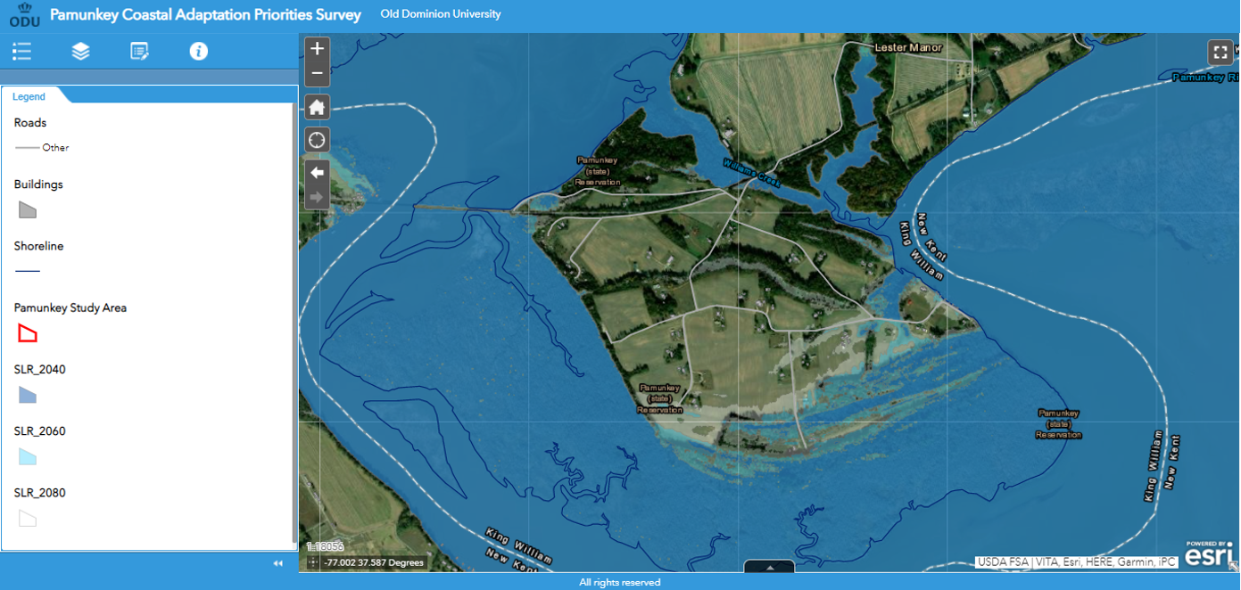
A web application was developed to accompany the surveys. Stephens and Richards (2020) showed that communicating the risk of sea level rise is more effective when lived experiences are geo-referenced and integrated into interactive visualization tools. The objective of the application was to allow users to draw shapes (points, lines, or polygons) to identify areas of concern. The application uses Esri’s Web AppBuilder application programming interface (API) as its platform. Eighteen data layers related to community use, sea level rise (projected for 2040, 2060, and 2080), and infrastructure are included through the layer list menu. A comprehensive data dictionary is included in Appendix 2 of this report.
The Pamunkey Coastal Adaptation Survey app opens with a disclaimer (Figures 1 and 2) that walks users through the editing tool used to create data. Users had to check that they read the guidelines to move forward in the application. Users were provided basic tool functionality such as being able to zoom in and out on the map, a legend showing data symbology, and the ability to turn the various data layers on and off. Additional functionality included a tool that allowed users to make contributions to the map by creating new features. As an editor, users had full capability to add, modify, or delete anything they create.
Figure 1. Coastal Adaptation Survey Application Directions
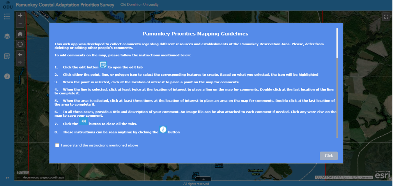
Figure 2. Coastal Adaptation Survey Application Layers
StoryMap
A visualization of adaptation and mitigation priorities was created using ArcGIS StoryMaps. Story maps offer a linear way to assimilate risk data and overcome feelings of fatalism or powerlessness by visually representing areas for improvement (Stephens & Richards, 202023). Content was based on the maps returned with surveys that were input into the web app.
Results
Flooding, Adaptation, and Mitigation on the Reservation
Shoreline erosion and reduced access to the reservation were currently the most reported effects of flooding. Damages to yards and homes were also of concern. Characterizations of flooding as a problem ranged from tremendous to minimal with the majority indicating that it is a big problem. Participants associated flooding with high tides, precipitation, and storm surge. All participants expected that flooding would get worse, restrict roadway use, cause additional erosion, and damage homes in the future. One participant also characterized the cultural importance, stating, “Near Powhatan’s burial ground, it is eroding fast and we are going to lose burials along with Powhatans.” Although one participant was not concerned about flooding, others identified land loss, stranding, and forced relocation as potential negative outcomes.
Mitigation and adaptation was in place from previous and current generations. Recent efforts include living shorelines, a bulkhead, and riprap. There is some disagreement among participants regarding whether or not previous generations thought about adaptation and mitigation, but irrigation ditches were installed between farms hundreds of years ago. Existing efforts were perceived by some participants to be effective at protecting structures and erosion with the exception of some fishing huts. The loss of even one fishing hut carries socio-economic significance. One participant explained, “Everything is positive except for taking down [name removed]’s shanty. He was the only fisherman left and they made him stop. That was the worst part.”
Despite these intergenerational efforts and effects, some participants lamented that more should have been done. One participant proposed that protection should have been extended to the whole shoreline. Another agreed that holding the existing shoreline was not enough, stating “I wish they could have done something because I’ve seen pictures and heard stories about how much it has changed from the 1900s. The shoreline used to be past the sycamore trees.”
Beyond the use of traditional knowledge to determine losses, the hunting and trapping of beavers and muskrat were proposed to reduce erosion and maintain irrigation projects. Traditional knowledge is also necessary to protect socio-economically relevant resources, such as clay and fish. One participant noted, “If mitigation for shoreline restoration or adaptation is done in certain areas, we may lose where we dig for clay.” Another perceived the impact of existing projects to be insufficient for fish stocks, stating “When the soil is not eroding, [it] is cleaner and the fish can make their beds. The river is getting more shallow and muddier and it’s making it hard for wildlife to survive.” Several participants stated that future mitigation efforts should use traditional knowledge to identify appropriate trees (such as cypress) and other plants that would prevent erosion and land for relocation. One participant emphasized the importance of preserving values and traditions when selecting mitigation options, where another participant thought modern solutions would be more appropriate.
Participants indicated that high costs prevented project expansion, but many thought that continuation was necessary regardless. Some participants recounted personally seeing changes in the low tide line, such as increased marsh areas, fallen survey poles from the 1960s, and reduced yardage along the river. Some participants wanted either the bulkhead or living shoreline to extend around the reservation. Grey infrastructure was suggested more often than green options. Preferences were also expressed for native plants over others used for living shorelines and bulkheads over riprap for structural protection. Raising houses, dredging, and wetland restoration were recommended as well. Land use change in favor of organic farming was also proposed by a couple of participants. One participant requested education on the effects of projects installed in the past ten years and the potential for metal barriers.
Participants agreed that additional mitigation and adaptation needed to start now. They proposed focusing on recently eroded areas, homes, roads, graves, sacred sites, historic structures, wetlands, and the single road that leads in and out of the reservation. Recommendations ranged from walls that stop the one- to two-feet of flooding experienced today to structures capable of preventing it for generations to come. Returning to the demolished fishing hut example, a participant expressed the need to balance environment and heritage, saying, “The oldest shanty was hastily destroyed because some people thought it was impacting the shoreline and creating more erosion at a faster pace. Had there been any thought to it, the structure could have been preserved and relocated or the land beneath the shanty could have been protected with barriers.”
Participants identified several challenges unique to the reservation. Internally, residence locations and governance were a concern. Land is not distributed in a way that protects new residents or protects existing residents from flood risk. Some recent residents experienced flooded fields shortly after arrival. Without the support of the chief and council, community priorities cannot progress externally. As administrations change, so does the willingness to promote mitigation and adaptation efforts.
Externally, a privately held railroad that sometimes carries toxic cargo crosses the reservation and river pollution from upstream both affect the reservation. Flooding around the railroad tracks has caused destabilization that could result in derailment. In such instances, the sheriff must be called to temporarily block the tracks until the railroad company can stabilize it. Runoff was another perceived external threat. When runoff from the county dump and farming chemicals pollute the river, residents of the reservation receive the highest levels of pollution because of their proximity. Negotiations with the individual landowners and the municipality are necessary to reduce pollution.
Sea level rise has reduced the land area of the reservation and altered the way the tribe interacts with the shoreline. Erosion has reduced fish stock and limited the fishing culture. Flooding occasionally prevents access to the reservation completely. Reduced hunting, trapping, and irrigating and increased farming compared to hundreds of years ago may have exacerbated erosion. Both built and natural structures have been recently installed to protect residential and community resources along the shoreline. Not all efforts have been culturally sensitive. Future mitigation and adaptation efforts could further alter the human-water relationship by limiting access to clay soils, shifting erosion to other areas, or changing the dominant plant species if not carefully planned with input from traditional ecological knowledge holders.
Mitigation and Adaptation Priorities, Resources, and Strategies for Future Sea Level Rise
Participants listed between one and five adaptation priorities using the web app (Figure 3 and Table 1). Features added included single points used as examples, sections of shoreline or road, and the entire reservation. Roads throughout the reservation, residences, structures, areas with the most erosion, and burial sites along the shoreline were top priorities including those near the fishing huts and boat ramps, which could be protected by extending existing mitigation structures. Secondary priorities included the road linking the peninsula to the mainland, a ditch or creek running the length of the reservation that consistently has one to four feet of water flowing through it, and community sites along the shoreline. Tertiary priorities involved residences and fishing locations along the shoreline near the fishing huts, the shoreline that is eroding the fastest, and residences throughout the reservation. Quaternary and quinary priorities were the artifacts, known and unknown, and graves, marked and unmarked, throughout the reservation.
Figure 3. Results of the Participatory Mapping Exercise
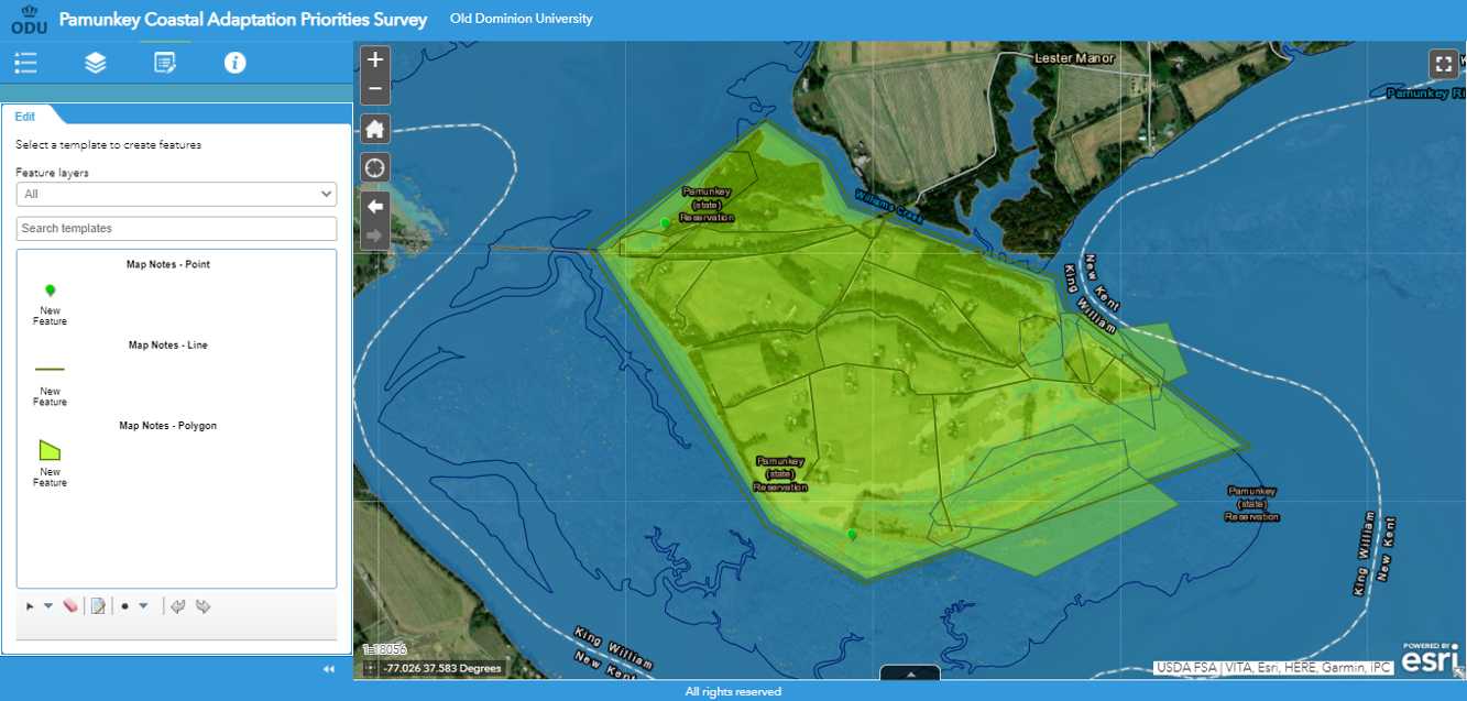
Table 1. Priorities Identified From the Participatory Mapping Exercise
| User Number | Priority Assigned | User Description |
| Points | ||
| U4 | 1/3 | Burial grounds along shoreline (example) |
| U4 | 2/3 | Community sites along shoreline (example) |
| Lines | ||
| U6 | 1/5* | Roads - need access |
| U6 | 2/5 | Shoreline—erosion prevents saving resources; example: hatchery and boat ramp |
| U1 | 2/2 | Entrance and exit |
| U3 | 2/2 | Already has one to four feet of water running through it |
| Polygons | ||
| U5 | 1/3 | Bulkhead extended past [name removed] residence |
| U5 | 2/3 | Creek floods into field after rain |
| U5 | 3/3 | Looks like that's where the reservation is losing most of the land |
| U6 | 3/5 | Residences—need access |
| U6 | 4/5 | Community use areas and archaeology—artifacts are spread across the whole reservation—want to save everything before it goes away |
| U6 | 5/5 | Graves—marked and unmarked |
| U2 | 1/1 | No annotation |
| U2 | 1/2* | Residences and homes along shoreline |
| U3 | 1/2 | No annotation |
| U4 | 3/3 | Residences and fishing locations along the shoreline |
The preservation of assets along eroding shorelines, residences, and roads held top priority. These fishing huts, boat ramps, and burial sites are associated with the continuation of traditional practices. The creek or ditch bisecting the reservation was of secondary concern to some. One extended lower priority to the whole reservation due to potential historic and cultural assets that had yet to be discovered. To explore the priorities further please visit the online StoryMap.
Reactions to Visualizations
When asked how the static or interactive map shifted priorities, participants stated that it increased their perception of urgency for adaptation and mitigation, reframed the effects of sea level rise, and peaked interest in additional spatial information. The maps shifted participant focus onto people’s homes or old ceremony grounds by showing the areas most affected. One respondent expressed concerns that sea level rise was “putting people on islands and peninsulas.” Some participants stated that dates in the map helped them realize the extent of the problem and the need to work faster to address it. The map led one participant to question whether or not a bulkhead would be able to stop the flooding. A couple participants indicated that the maps could support additional focus on preserving and integrating traditional practices in future mitigation and adaptation planning efforts.
One respondent, reflecting on traditional knowledge as a way to address sea level rise shown on the map, said, “It tells us that we need to move. That is what we did for centuries.” The land ownership situation of and on the reservation must be considered in flood management options and timeline. One participant shared, “A lot will happen in 20 years and we need to be planning now. Even if the plan is to relocate—we need to know if we can buy land elsewhere; the cost of moving, buying a house or building a house, renting. Everyone on the reservation either built/bought their home or inherited it. We do not have mortgages on the reservation and cannot sell our homes to non-tribal members, so there is more planning and effort involved than the average person who is looking to move.” Participants called for additional information to help with advocacy, including data on storm surge, current sea levels, elevation and depth data, projected erosion, areas with the potential for uninhabitable marshland and wetland development, previously held territory, and simulations of what can stop flooding.
Progression of Priorities Over Time
The Resilience Matrix addresses risk holistically by incorporating hazardous natural systems and processes, such as storm impacts, sea level rise and tidal flooding with vulnerable resources, such as ecosystems, infrastructure, and socio-economic and cultural assets. Participants addressed elements of vulnerability in their list of resources and strategies for flood management (Tables 2 and 3). Most suggested strategies addressed vulnerabilities through structural mitigation such as, constructing bulkheads, flood gates, levees, and pump stations and elevating roads, structures, and shorelines. Some strategies relied on ecological functions to reduce flooding, such as introducing strategic vegetation and protecting wetlands. However, participant recommendations were not without hesitation over how modifications of any kind could have unintended effects. One participant expressed concern that extensive structural mitigation would shift waterflow elsewhere and cause ecological damage there. Another noted that activities like dredging and regrading would need to be timed to not interfere with wildlife breeding.
Table 2. List of Resources to Be Developed
| Physical | Information | Cognitive | Social |
Pump Stations |
|
|
|
Table 3. Sea Level Rise, Tidal Flooding, and Storm Impact Reduction Strategies
| Physical | Information | Cognitive | Social | |
| Prepare |
|
|
|
|
| Absorb |
|
|
|
|
| Recover |
|
|
|
|
| Adapt |
|
|
|
|
The Resilience Matrix sorts resources into systems (physical, information, cognitive, and social) that are interdependent. For example, proposed physical projects were often too large for the community members to implement without support. More information, internal communication, and external advocacy about flood risk and mitigation technology was desired in the form of maps, blueprints, trainings, and impact assessments. Participants suggested developing a flood control plan to balance these strategies. One participant suggested the plan encompass seven generations. Another noted that the livable land needed to accommodate 100 people. Community, nonprofit, private sector, and tribal and federal government actors were identified as stakeholders to engage in planning efforts.
The Resilience Matrix identifies four phases for implementation: preparation, absorption, recovery, and adaptation. Breaking down the proposed flood management strategies into phases identified how vulnerability will be reduced, when various actors should be involved, and benchmarks that could be set. This timeline could help overcome fatalistic feelings. For example, one participant expressed “I still don’t think we can adapt to flooding, but we can try to prepare for it.” Analyzing vulnerability data, communicating risk, and setting waterflow limits were proposed short-term preparation activities. Participants also wanted the internal capacities to reinforce mitigation structures, transportation routes, and buildings for flood readiness. Intermediate suggestions for absorption and recovery included expanding stakeholder involvement for relief efforts, limiting flood damage, and setting rebuilding and remediation standards to progressively relieve stress from individuals and the community. Long-term adaptation suggestions involved training and workshops on waterproofing and risk reduction. Proposed adaptation strategies also emphasized the need to leverage federal resources to implement grey and green mitigation projects and possibly relocate.
These strategies are not without challenges, opportunities, and gaps. Participants identified financing costly mitigation technology, building awareness, administration composition, ongoing threats of storm surge, and securing suitable land for relocation as challenges. Opportunities to acquire more traditionally held land and leveraging the core population of Pamunkey citizens for implementation were also stated. Participants reflected that some resources that did not fall within the designated categories of the Resilience Matrix were still critical to mitigation and adaptation, such as increasing financial resources and federal involvement—Federal Emergency Management Agency (FEMA) and the Environmental Protection Agency (EPA) such as project funding, for instance—and forming a flood management and planning committee.
Discussion
Recommendations and Future Research
Traditional ecological knowledge can inform the elements, locations, and extent of mitigation and adaptation projects. Once the priorities are set, action to protect, preserve, and relocate culturally and economically valuable assets can begin. Timelines for implementation must be adjusted to create change before sea level rise prevents access.
For the Pamunkey Indian reservation, priorities include homes and heritage sites along the shoreline, the road in and out of the reservation, and the preservation of artifacts and graves across the reservation. Homes could be protected by an extended bulkhead or other water retention structure, elevating them, or relocating them. The entrance and exit road could also be protected by water retention structures, elevation, or adding an additional evacuation route. The reservation as a whole could benefit from the aforementioned options as well as water removal pumps; traditional water, wildlife, and land management practices; and planning efforts to identify and secure a suitable alternative location and the means to relocate. These results could contribute to the development of a Pamunkey Indian Reservation mitigation plan that could be submitted to the Virginia Department of Emergency Management Post-Disaster Hazard Mitigation Grant program. It could also be used to prioritize grant proposals to federal agencies, such as FEMA, EPA, and NOAA.
Future studies should model future sea level rise with various mitigation and adaptation options implemented and integrate a traditional ecological knowledge framework for planning. Furthermore, research should also include external stakeholders involved in the use and regulation of the Pamunkey River to ensure the priorities of coastal tribes have broad support. Histories should be collected from or reviewed with elders from other coastal tribes to identify similarities and differences in how traditional practices might have contributed or could contribute to flood management. A resilience model for coastal tribes dealing with the impacts of climate change should be developed from collective analysis across multiple tribes and stakeholders.
References
-
Bethel, M.B., Brien, L.F., Esposito, M.M., Miller, C.T., Buras, H.S., Laska, S.B., Philippe, R., Peterson, K.J. and Parsons Richards, C. (2014). Sci-TEK: A GIS-based multidisciplinary method for incorporating traditional ecological knowledge into Louisiana's coastal restoration decision-making processes. Journal of Coastal Research, 30(5), pgs. 1081-1099. ↩
-
Middle Peninsula Planning District Commission (MMPDC). (2016). All Hazards Mitigation Plan Update. https://www.mppdc.com/articles/reports/FEMA_Approved_Final_Plan_RED_Part1.pdf. (Accessed 11th September 2019). ↩
-
Bethel, M.B., Brien, L.F., Danielson, E.J., Laska, S.B., Troutman, J.P., Boshart, W.M., Giardino, M.J. and Phillips, M.A. (2011). Blending geospatial technology and traditional ecological knowledge to enhance restoration decision-support processes in Coastal Louisiana. Journal of Coastal Research, 27(3), pgs. 555-571. ↩
-
Spivey, A. (2017). "Knowing the River, Working the Land, and Digging for Clay: Pamunkey Indian Subsistence Practices and the Market Economy 1800-1900". Dissertations, Theses, and Masters Projects. Paper 1516639670. ↩
-
Kleinosky, L.R., Yarnal, B. and Fisher, A. (2007). Vulnerability of Hampton Roads, Virginia to storm-surge flooding and sea-level rise.Natural Hazards, 40(1), pgs. 43-70. ↩
-
Virginia Department of Environmental Quality. (2019). Virginia Coastal Geospatial and Educational Mapping System (GEMS). http://www.coastalgems.org/ ↩
-
Ezer, T. (2018). The Increased Risk of Flooding in Hampton Roads: On the Roles of Sea Level Rise, Storm Surges, Hurricanes, and the Gulf Stream. Marine Technology Society Journal, 52(2)8, pgs. 34-44. ↩
-
Weichselgartner, J. & Kelman, I. (2015). Geographies of resilience: Challenges and opportunities of a descriptive concept. Progress in Human Geography, 39(3), pgs. 249-267. ↩
-
Titus, J. G. et al. (2009). Coastal Sensitivity to Sea-Level Rise: A Focus on the Mid-Atlantic Region. Digital Library. https://digital.library.unt.edu/ark:/67531/metadc12028/. ↩
-
Yin, J. & Goddard, P. B. (2013). Oceanic control of sea level rise patterns along the East Coast of the United States. Geophys. Res. Lett. 40, pgs. 5514–5520. ↩
-
Baldassarre, G.D., Kooy, M., Kemerink, J.S. and Brandimarte, L. (2013). Towards understanding the dynamic behaviour of floodplains as human-water systems. Hydrology and Earth System Sciences, 17(8), pgs.3235-3244. ↩
-
Siegrist, M. & Gutscher, H. (2008). Natural hazards and motivation for mitigation behavior: People cannot predict the affect evoked by a severe flood. Risk Analysis: An International Journal, 28(3), pgs. 771-778. ↩
-
Schäffler, A. & Swilling, M. (2013). Valuing green infrastructure in an urban environment under pressure—The Johannesburg case. Ecological Economics, 86, pgs. 246-257. ↩
-
Hutton, N., G. Tobin, and B. Montz (2018). The Levee Effect Revisited: Processes and Policies Enabling Development in Yuba County California. Journal of Flood Risk Management,12(3), e12469. ↩
-
Dietz, M.E. (2007). Low impact development practices: A review of current research and recommendations for future directions. Water, air, and soil pollution, 186 (1-4), pgs. 351-363. ↩
-
Bilkovic, D.M., Mitchell, M., Mason, P. and Duhring, K. (2016). The role of living shorelines as estuarine habitat conservation strategies. Coastal Management, 44(3), pgs.161-174. ↩
-
Toft, J.D., Ogston, A.S., Heerhartz, S.M., Cordell, J.R. and Flemer, E.E. (2013). Ecological response and physical stability of habitat enhancements along an urban armored shoreline. Ecological Engineering, 57, pgs.97-108. ↩
-
O'Donnell, J.E. (2016). Living shorelines: A review of literature relevant to New England Coasts. Journal of Coastal Research, 33(2), pgs.435-451. ↩
-
National Oceanic and Atmospheric Administration. (2015). Habitat Blue Print. https://www.habitatblueprint.noaa.gov/living-shorelines/ ↩
-
Sutton-Grier, A., Gittman, R., Arkema, K., Bennett, R., Benoit, J., Blitch, S., Burks-Copes, K., Colden, A., Dausman, A., DeAngelis, B. and Hughes, A. (2018). Investing in natural and nature-based infrastructure: building better along our coasts. Sustainability, 10(2), pgs. 523. ↩
-
Strickland, S. M., King, J. A., and McCartney M. (2019). Defining the Greater York River Indigenous Cultural Landscape. Report, St. Mary’s College of Maryland, St. Mary’s City MD. ↩
-
Allen, T. & Crawford, T., Montz, B., Whitehead, J., Lovelace, S., Hanks, A., Christensen, A., Kearney, G. (2018). Linking Water Infrastructure, Public Health, and Sea Level Rise: Integrated Assessment of Flood Resilience in Coastal Cities. Public Works Management & Policy. 24(1), pgs. 110-139. ↩
-
Stephens, S., & Richards, D. (2020). Story Mapping and Sea Level Rise: Listening to Global Risks at Street Level. Communication Design Quarterly, 8(1), pgs. 5-18 ↩
Hutton, N. S., & Allen, T. R. (2021). The Traditional Ecological Knowledge and Mitigation Nexus: The Pamunkey Indian Reservation (Natural Hazards Center Mitigation Matters Research Report Series, Report 1). Natural Hazards Center, University of Colorado Boulder. https://hazards.colorado.edu/mitigation-matters-report/the-traditional-ecological-knowledge-and-mitigation-nexus