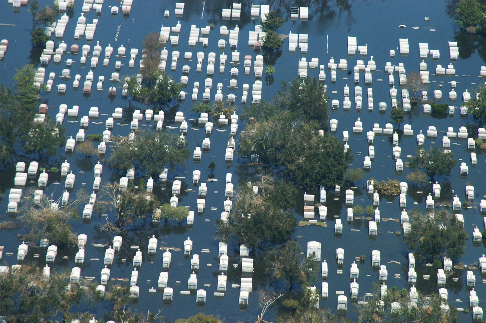
Fig. 1 - At a distance, a flooded cemetery seems serene, belying the destruction wrought. This is a New Orleans cemetery in the aftermath of Hurricane Katrina in 2005 © FEMA
HURRICANE KATRINA caused more devastation than any other disaster in U.S. history, including roughly $125 billion in damages (Amadeo, 2016). The losses that this Category 5 hurricane inflicted on August 29, 2005, extended well beyond fiscal accounting and included heritage and history. More than 1,500 graves sites were destroyed, displaced, or dislocated by wind and flooding. From Diamond Cemetery, established in 1800 in Plaquemines Parish, New Orleans, caskets were scattered far and wide, many deposited on adjacent properties and in streets. Five five months later, the search for displaced bodies continued. For families, the anguish of loved ones missing from their graves was renewed by having to rebury them, as if they had died again (Cornish, 2006). Diamond Cemetery and many other cemeteries in the region still bear the scars of Katrina 11 years later, and will never be as they were, though cemetery restoration is technologically feasible.
Separate from the ravages of Katrina, gravestones are routinely repaired, restored, and reset, and occasionally entire cemeteries are returned from the ravages of benign neglect or vandalism. Gravestone and cemetery preservation and restoration have become important areas of cemetery studies. Cemeteries as cultural landscape are as vulnerable to the impacts of disasters as community infrastructures, though little attention has been given to the potential devastation of cemeteries by disasters.1 Such damages have been increasing due to impacts of climate change, such as flooding and land erosion. The solvency and ability to restore cemeteries depend on regularly updated disaster plans in tandem with electronic/technological surveys kept current. The importance of cemeteries to communities justifies the effort.
As representations of communities and their histories, burial grounds embody the spirit and essence of those who lived and died in those communities
The value of cemeteries as archives of community history is well established and enhanced by their omnipresence.[^2] Communities too small to have had town halls or public buildings, libraries, post offices, elected officials, or written minutes and records, have had cemeteries. Sometimes they have been the only remaining record of a community’s existence. Cemeteries possess institutional importance as the “last great necessity” (Sloane, 1991: xxii) in society. First, cemeteries (historic and active) are culturally significant; they represent familial and community identity, a matter of importance in losses wrought by disasters. Second, cemeteries are historically significant, providing anchors and continuities for communities. Third, cemeteries are emotionally significant as places to nurture and continue relationships with the past; restoring sacred spaces is vital for the emotional recovery of communities. Some minority communities (e.g., African American, Hispanic, Native American) that firmly embrace traditions and histories are particularly sensitive to the loss of sacred spaces. As representations of communities and their histories, burial grounds embody the spirit and essence of those who lived and died in those communities. As such, these sacred places enable reconstructions of community, even in the absence of traditional records and documents.2

Fig. 2 - Even close up, the damage seems “wet,” but minimal. This is St. Louis No. 1 Cemetery in New Orleans, following the aftermath of Hurricane Katrina in 2005. © FEMA
Clearly, cemeteries, historic and active, need to be preserved. Cemeteries should not have to be old to be cultural resources. Further, they are businesses, private or public, profit or nonprofit. Most businesses would be negligent if they operated without insurance against all kinds of losses, and insurance is a cost of doing business. Cemetery disaster planning is a kind of insurance, and like any insurance, it is reluctantly purchased, with the hope that there is never a claim submitted. The loss of cemeteries can be tantamount to the loss of communities, as well as their histories and identities. This comparison rings true especially when communities have declined so much that only cemeteries remain. The need to protect and ensure cemeteries is a matter of cultural preservation and responsible business management.
Cemetery Impacts
The Federal Emergency Management Agency (FEMA) has an expansive digital library of photographs that document the various impacts of disasters. The library hosts photographs of damage to cemeteries. Ironically, cemeteries are regarded as permanent. For instance, grave space is sold, not rented (as in Europe), and the adage “cut in stone” implies permanence. However, the photographic evidence 3 reveals both their impermanence and unimaginable devastation. The geographical location of cemeteries determine the types of disasters to which they are most susceptible, e.g., hurricanes in gulf coast states and wildfires in California. Damage can include deposition of soil, sand, and litter, gravestone displacement, gravestone damage, erosion, disinterment of caskets—sometimes with displacement far from original location—spalling and thermal fracturing of stones.
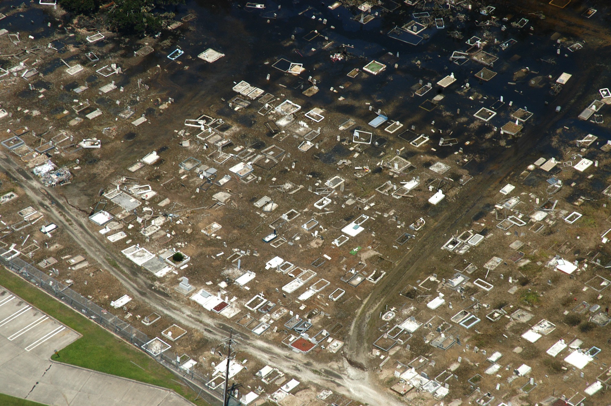
Fig. 3 – Once waters recede, the devastation becomes apparent, even at a distance. © FEMA
Undeniably, water produces an incredible force, weighing about 1,700 pounds per cubic yard. It can displace 1,500 pounds for foot of flood water (Chicora Foundation, Inc., 2013). In 1993, the Missouri River flooding displaced about half of the 1,500 grave sites in Hardin, Missouri. The flooding associated with Hurricane Floyd, in 1999, displaced over 200 caskets from cemeteries in North Carolina. In 2005, Hurricane Katrina’s flooding displaced hundreds of caskets in Mississippi, Alabama and Louisiana. During Texas Hurricane Ike in 2008, flooding displaced caskets and opened vaults in cemeteries. In 2012, Hurricane Isaac’s flooding displaced hundreds of caskets in Braithwaite, Louisiana, some as far as a quarter-mile. When burials are displaced from graves and disassociated from gravestones, they have to be identified by forensic pathologists at considerable time and expense, sometimes without success (Chicora Foundation, Inc., 2013). Contemporary caskets are manufactured with serial numbers, but there is no singular standard or requirement for funeral homes to utilize those numbers in any identification system. Hurricanes Katrina and Rita illustrate this point, as many coffins lacked identification. Some coffins from the 1960s and later were identified because they contained burial scrolls with names of the deceased, and some were identified by serial numbers and hand-drawn maps. However, others had to be identified by rosaries, scars, pacemakers, x-ray evidence or by visual identification or DNA match (Koppel, 2005).
Responsibility for recovery and identification is also sometimes problematic depending on the age and location of the exposed human remains. In some states (e.g., Illinois), human remains less than 100 years old are the purview of coroners or medical examiners. Those more than 100 years old are the purview of the Illinois Historic Preservation Agency. Mass disinterments, which may be the result of disaster events, especially in active cemeteries, are generally the responsibility of Disaster Mortuary Operational Response Teams (DMORT) of the Department of Health and Human Services (Chicora Foundation, Inc., 2013). The ambiguity regarding the recovery of human remains underscores the importance of having disaster plans that could identify and delineate those responsibilities prior to implementation (see figs. 1, 2, 3, and 4 for devastation by floods).
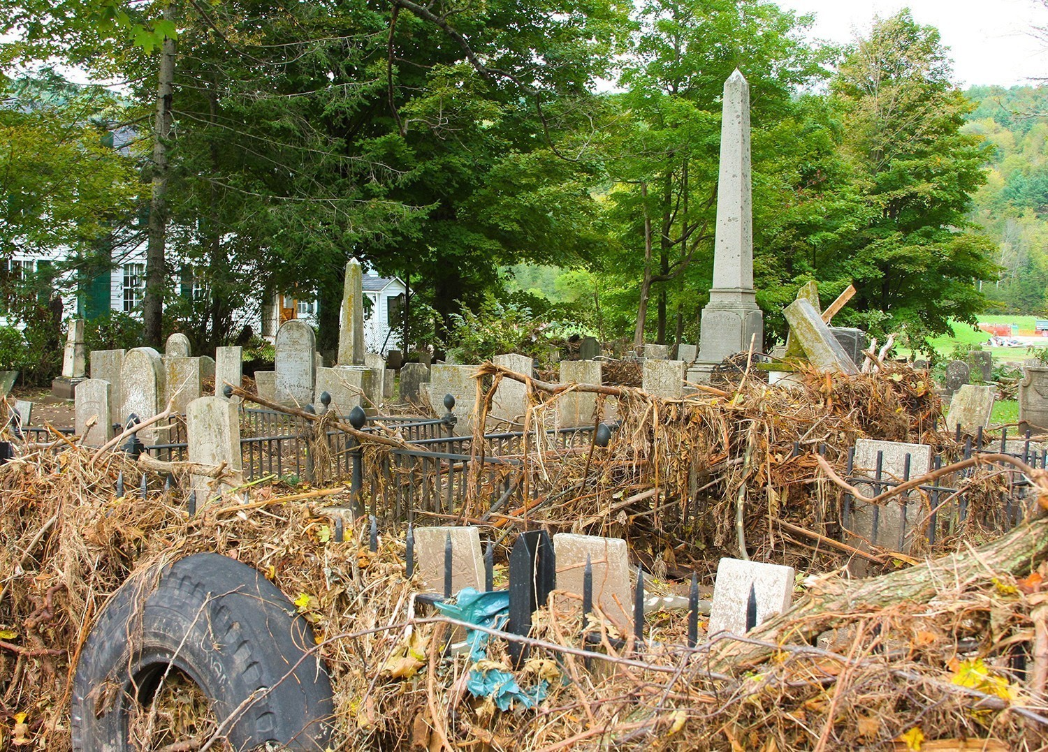
Fig. 4 – Upon closer examination, and after the waters recede, the magnitude of the cleanup that awaits becomes obvious. © FEMA
Tornadoes can also cause significant damage to cemeteries and as winds from an EF1 tornado of even one-hundred miles-per-hour can have a pressure of 25 pounds per square foot, yielding wind loads of thousands of pounds on structures and other large objects (Chicora Foundation, Inc., 2013). This force can topple trees and blow debris as large as vehicles and structures. It can even completely strip the ground of all monuments such as headstones, footstones, corner markers or other important ground features. For instance, the 2011 New England tornado cluster spawned six tornadoes, the most severe of which was rated EF3. Several cemeteries suffered damage. For example, 19 stones were damaged at the Norcross Cemetery, and 20 were damaged at the North Main Street Cemetery in Monson, Massachusetts (Stabile, 2011). In nearby Wilbraham, the Adams Cemetery sustained significant damage (McLaughlin, 2011; see figs 5, 6, 7 and 8 for damage caused by tornadoes and high winds).
Among natural disasters, earthquakes, wildfires, mudslides, and others also have ravaged cemeteries (Chicora Foundation, Inc., 2013). Mudslides, associated with earthquakes or torrential rains, and with a density of 1.5 tons per cubic yard potentially moving at more than 30 miles per hour, can cover or dislodge gravestones, carrying them in the current for at least hundreds of yards (see Fig. 9).
Heat can wreak havoc on cemeteries. Wildfires, covering many square miles, can exceed temperatures of more than 1,400oF. This thermal shock can cause gravestones to crack, spall, and explode. High temperatures can melt aluminum and bronze markers. Further, soot discolors permeable stone. Roughly 45 states have moderate to high risk of earthquakes, and the potential damage to monuments and mausoleums is significant. The 1906 San Francisco earthquake damaged more than 75 percent of the monuments in Colma’s Holy Cross Cemetery (Chicora Foundation, Inc., 2013). (See fig. 10 for cemetery damage by earthquakes.) We believe that the FEMA photographs we use and additional photographs in their media library document the damage that can be done to cemeteries and provide evidence to support our assertion that proactive, disaster-planning measures are warranted. The photographs illustrate cemeteries as physical space and material culture. Less obvious is the damage to and loss of cemeteries as cultural space and community history. Once again, without a disaster plan, the long-term impacts can be much worse and the ability to recover can take much longer.
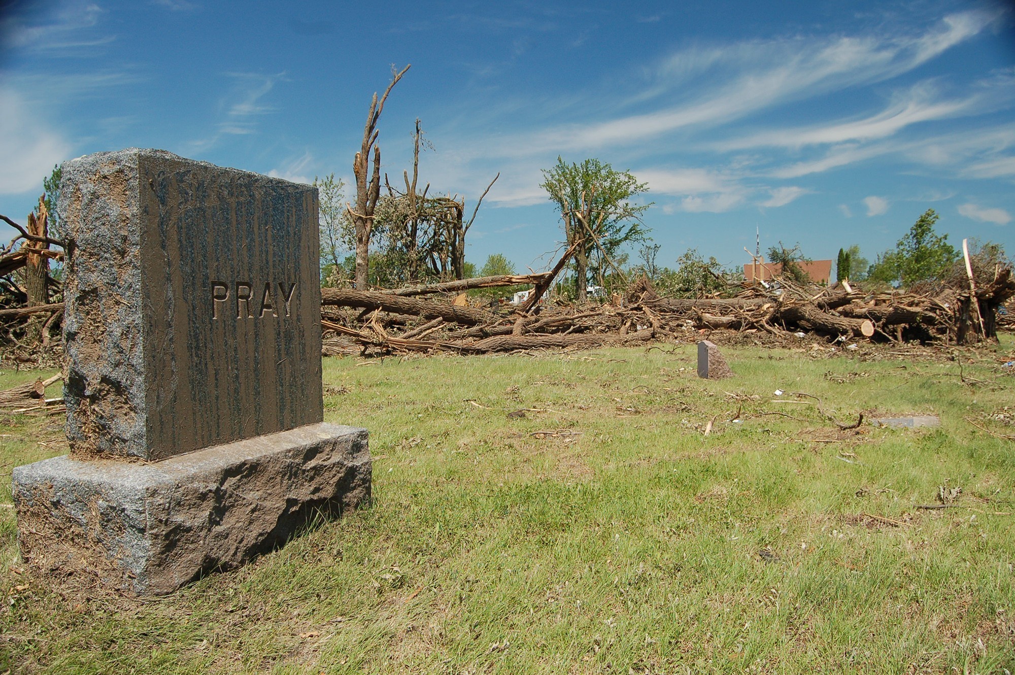
Fig. 5 – While the winds of tornados can reach velocities that can topple stones and destroy mausoleums, the greatest threats of destruction come from toppling trees and blowing debris. Vegetative debris has been blown onto the end of the gravestone that now needs cleaning. The family name on the stone is fitting and appropriate. © FEMA
Disaster Planning
The challenges of disaster planning for cemeteries vary by location or geography. Different geographic locations are susceptible to different types of disasters. Federal agencies (FEMA, National Oceanic and Atmospheric Administration, U.S. Geological Survey, American Society of Civil Engineers, United States Department of Agriculture, Occupational Safety and Health Administration), as well as state, county, and municipal emergency-management websites, can identify those threats.4 Cemetery operators should evaluate the risks to which their property most vulnerable. However, such assessments must be conducted according to the specific conditions and characteristics of each particular cemetery. For instance, dead, diseased, and old trees are susceptible to hurricanes, tornados, and high-wind events. Dense brush and vegetative litter are vulnerable to wildfires. Low-lying topography with poor drainage is susceptible to flooding. Monuments that are unstable or leaning more than five degrees from perpendicular. Many conditions can be addressed beforehand to minimize damage in the event of some disaster, and it is necessary to evaluate conditions in the context of hazards in order to inform and guide the development of effective plans.
Active, contemporary cemeteries, often for-profit businesses, may utilize state-of-the-art management technologies such as Geographic Information Systems (GIS). GIS combines geographic (spatial) data with information (non-spatial) data, and is used to collect, store, edit, manage, query, and display information visually, typically as various types of maps. A cemetery GIS would include information (spatial data) such as headstones, footstones, and plot corner markers, as well as planimetric features, such as roadways, utilities, and landscaping. Other information (non-spatial, or aspatial data) may include burial records, obituaries, death certificates, photographs of headstones and other cemetery peripherals, or any other form of digital records that may be associated with interments.5 Together, these data constitute a robust, powerful tool for the management of cemetery information, and can exist in both digital (e.g., on a server) and non-digital formats (printed maps), and are the archives of the modern-day sexton.
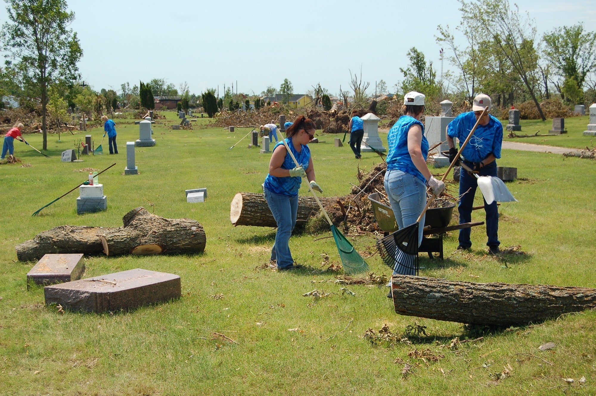
Fig. 6 – Downed trees can topple and break gravestones, dislocating them from their original gravesites. © FEMA
Having a digital inventory of any cemetery is valuable. Having a spatially accurate representation of its monuments and infrastructure is even more valuable. The use of Global Positioning Systems (GPS) and Total-Station methodologies 6 to map marked graves, and explorative geophysical methods such as GPR (Ground-Penetrating Radar) and Electromagnetic Induction (EMI) for mapping unmarked graves is not uncommon. Such technologies are expensive to acquire, are often labor-intensive, and require considerable expertise, training, and education. However, implementation of such technologies assure the ability to comprehensively reconstruct the cemetery in its entirety.
The various technologies employed must be appropriate to the characteristics and geographic setting of the cemetery. For example, some Differential Global Positioning System (DGPS) methods require connection to a base station using cellular, spread spectrum, or Ultra High Frequency (UHF) radio, and in the absence of one of these components (e.g., an area with no cellular coverage), the use of survey-grade GPS is precluded. Similarly, trees and tree canopy can be problematic, as heavy canopy will impede acquisition of the GPS signal. For cemeteries completely bounded within a forested area, multipath errors (reflection of the GPS satellite signal) will be a significant source of error in horizontal measurement. Alternatively, however, GPS ephemeris collected (GPS coordinates measured at a stationary point) over extended occupational periods in such environments can facilitate cumulative establishment of survey-grade horizontal and vertical control for use with other non-GPS methodologies, such as use of a Total Station, for mapping all cemetery and planimetric features.
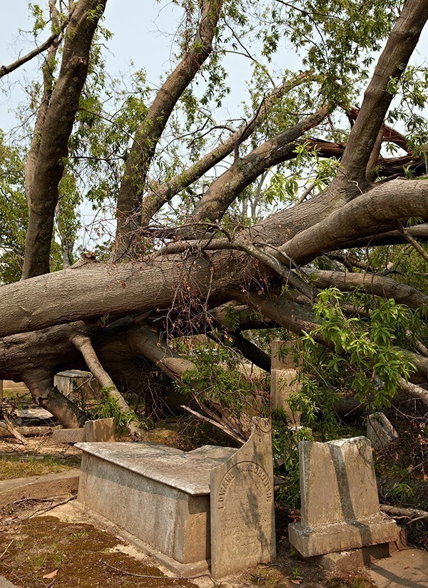
Fig. 7 – Downed trees can topple and break gravestones, dislocating them from their original gravesites
The objective of cemetery mapping is to establish the exact (not relative) location of each interment in a cemetery using real-world (non-arbitrary) planar coordinates, and to capture digital photography (when applicable) of each gravestone. A cemetery GIS model links the photographs and other pertinent (aspatial) interment information to its spatial compliment—the headstone or marker. An accurate grave location is not dependent on its relative proximity to adjacent graves, as may be the case in cemeteries mapped using arbitrary coordinates, or in absence of an accurate Cartesian coordinate system altogether. If the locations of adjacent graves were lost or destroyed, relative locations would be meaningless. Any burial location mapped with survey-grade GPS (1–2 cm accuracy) represents a singular, unique location on the surface of the earth that can be relocated independent of other monuments.
Area colleges and universities with GIS centers may be valuable resources in offering advice, consulting, and even services, either gratis or fee-for-service. An additional incentive for universities’ involvement might be students having access to the cemetery, a hands-on learning lab for the use of GIS and field-mapping technologies. Alternatively, private companies offer GIS services, and many municipalities routinely contract for a variety of their services. Initial inquiry might be made of city managers, planners, or disaster-plan coordinators and officers to identify such companies. The imagined expense is probably less than the actual expense, and the actual expense is, in the end, far less than the cost of doing nothing. GPS and/or Total-Station surveys of very large cemeteries can be completed in a matter of days to weeks.
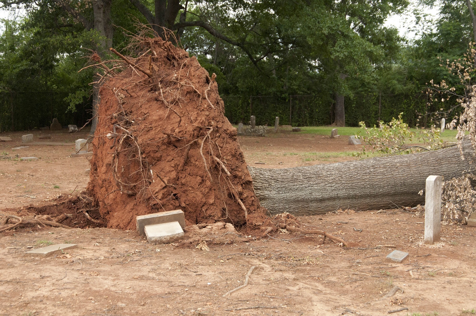
Fig. 8 – Uprooted trees can expose burials and compromise graves, requiring reinterment. © FEMA
The digital or virtual construction of the cemetery, once amassed, may be stored on a server, and conveyed to cemetery administrations for access or archiving on their computers. However, the conventional wisdom is to not store electronic data, including the cemetery reconstruction and its disaster plan, only on computers at or near the cemetery. The adage “don’t place all of your eggs in one basket” has merit; multiple copies, hard and electronic, should be distributed and stored, near and far. Disasters have no respect or regard for cemeteries, nor for computer servers in their path. In 1917, a tornado swept across the Midwest, destroying the sexton’s office at the Dodge Grove Cemetery in Mattoon, Illinois. Most of the paper records were destroyed, and had they been electronic records on a single computer in the office, they would have been lost, too.
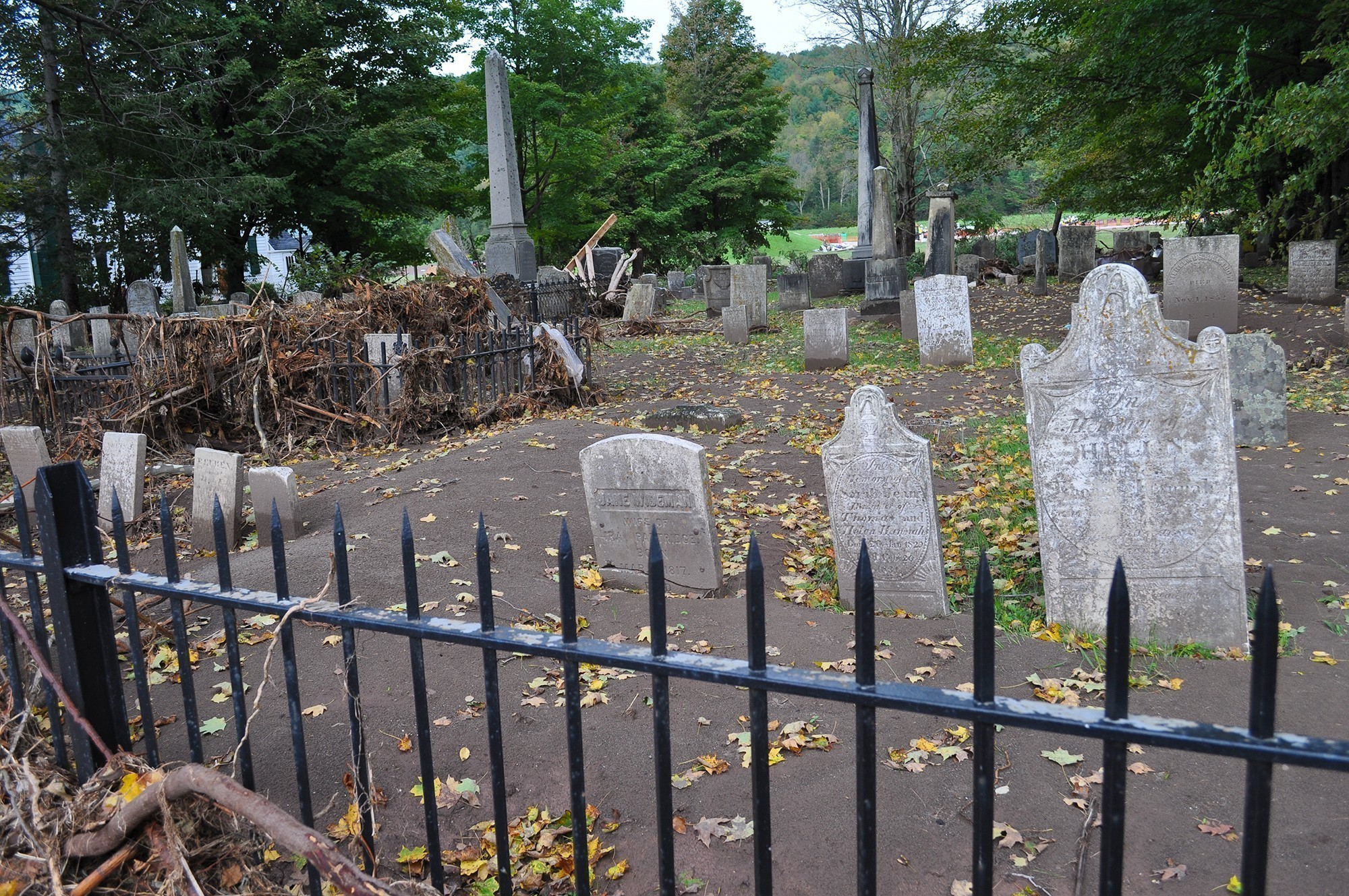
Fig. 9 – Mudslides and floods deposit an overburden of silt and mud that is best removed by the techniques of archaeological excavation. The use of skid loaders and frontend loaders can be too imprecise and aggressive, disturbing the original surface of the cemetery. © FEMA
Summary Recommendations
Disaster plans and the electronic/technological surveys that enable the reconstruction of cemeteries are two distinct but interrelated documents and efforts. Even a fully developed and comprehensive plan cannot restore and preserve the cemetery without an accompanying (electronic) model of the cemetery, and an electronic reconstruction becomes a vulnerable and futile document without a disaster plan. Additionally, some of the most at-risk cemeteries are those that reflect the most extensive history and heritage of a community. They are often small, secluded, inactive, and infrequently maintained without sexton or administrator, and without any means of support. They are just there, located in a dense forest or an overgrown field. In such a state, the completion of an electronic survey and reconstruction, and an accompanying disaster plan, initially seem challenging. However, such cemeteries possess assets that active cemeteries cannot purchase -- namely, the asset of historical interest and place. With advocates such as local historical and genealogical societies that will make the case of preservation and protection compelling, university and college history departments and GIS centers may be more persuaded to make services available. If the goals of electronic surveys and disaster plans can be clearly articulated, such cemeteries become candidates for community and corporate sponsors. Such cemeteries would be dependent upon volunteers to activate and implement a disaster plan, just as they are dependent upon volunteers to create the disaster plans, with all efforts dedicated to ensuring the integrity of history and heritage. Contemporary, active cemeteries will be expected to remunerate GIS services. They might consider writing a line item into annual budgets for GIS services or consider a GIS specialist as part of their staffing plans.
Fig. 10 – Earthquakes fracture and topple stones, and compromise or damage public and family mausoleums © FEMA
Cemetery disaster plans and the GIS surveys upon which they are based are a kind of insurance against a claim ever having to be filed. They are also investments. For active cemeteries, GIS surveys are an alternative means of precisely monitoring the inventory of occupied and available lots. And for inactive, historic cemeteries, GIS surveys document and replicate the cemeteries electronically. Such surveys, once in place, allow disaster plans to be implemented, and they enable a literal and physical reconstruction of cemeteries. That, in turn, protects cemeteries as cultural resources and intellectual real estate. With the documentation of GIS surveys and disaster plans in place, cemeteries impacted by disasters may qualify for federal (FEMA) grants in their recovery and reconstruction efforts. Absent those proactive precautions, cemeteries, active and inactive, will experience losses that can be accurately estimated in dollars, but culturally and historically will be incalculable.
After a disaster we often attempt to recreate a sense of normalcy. We do this by searching through rubble and trying to find anything that is of value to us. Sometimes we find photographs, important family heirlooms, a child’s favorite toy or teddy bear, or other family possessions that help us cope with the emotional devastation of the disaster, and to recover. In other situations, protecting or having the capacity to rebuild a cemetery or replace a loved one’s headstone may be what helps us recover, as cemeteries are a vital connection between past and present. As a cemetery CEO, sexton, genealogist, local historian, passionate taphophile, or family member, the only thing worse than having to implement a disaster plan is having no plan to implement.
References
Amadeo, Kimberly. 2016. “Hurricane Katrina Facts: Damage and Economic Effects.” About Money, May 5, 2016. http://useconomy.about.com/od/grossdomesticproduct/f/katrina_damage.htm (accessed on July 29, 2016).
Chicora Foundation, Inc. 2013. Cemetery Disaster Planning. Columbia, SC: Chicora Foundation, Inc. www.chicora.org
http://www.chicora.org/pdfs/Cemetery%20Disaster%20Planning.pdf (accessed on August 1, 2016).
Cornish, Audie. 2006. “Floods Didn’t Spare New Orleans Graveyards.” All Things Considered, NPR News, January 28, 2006. http;//www.npr.org/templates/story/story.php?storyid=5176560 (accessed on July 29, 2016).
Foster, Gary S., and Craig M. Eckert. 2003. “Up from the Grave: A Socio-Historical Reconstruction of an African-American Community from Cemetery Data in the Rural Midwest.” Journal of Black Studies. 33: 468-489.
Foster, Gary S., and Michael G. Gillespie. 2013. “Yuma Territorial Prison Cemetery: Cold Cases of Grave Importance,” Illness, Crisis, and Loss. 21(1): 29-49.
Foster, Gary S., and William E. Lovekamp. 2015. Disasters and Cemeteries: A Clarion Call for Matters of Grave Urgency.” Association of Gravestone Studies Quarterly 39(3):14-19.
Koppel, Lily. 2005. “Coffins and Buried Remains Set Adrift by Hurricanes Create a Grisly Puzzle.” The New York Times, October 25, 2005.
http://mobile.nytimes.com/2005/10/25/us/nationalspecial/coffins-and-buried-remains-set-adrift-by-hurricanes.html?_r=0 (accessed on August 1, 2016).
Martineau, Harriet. 1989 [1838]. *How to Observe Morals and Manners*. New Brunswick, NJ: Transaction Publishers.
McLaughlin, Suzanne. 2011. “Wilbraham Will Seek to Renovate Historic Adams Cemetery Damaged in Tornado.” *The Republican*. July 12, 2011.
http://www.masslive.com/news/index.ssf/2011/07/wilbraham_will_seek_to_renovat.html (accessed on June 29, 2016).
Stabile, Lori. 2011. “Tornado Damaged Monson’s Cemeteries, Memorial Hall.” *The Republican*. August 9, 2011.
http://www.masslive.com/news/index.ssf/2011/08/tornado_damaged_monson_cemeter.html (accessed on June 29, 2016).
-
For an earlier version of this paper, see Foster, Gary S. & William E. Lovekamp. 2015. “Disasters and Cemeteries: A Clarion Call for Matters of Grave Urgency.” Association of Gravestone Studies Quarterly 39(3):14-19.
[^2]:Harriet Martineau (1838) was the first to view cemeteries as important sources of information, archiving cultural values and beliefs, and socio-demographic insight in the absence of vital records and statistics. ↩ -
For examples of reconstructing communities from cemetery data, see Foster, Gary S. and Craig M. Eckert. 2003 “Up From the Grave: A Socio-Historical Reconstruction of an African-American Community from Cemetery Data in the Rural Midwest,” Journal of Black Studies 33: 468-489. Foster, Gary S. and Michael Gillespie. 2013. “Yuma Territorial Prison Cemetery: Cold Cases of Grave Importance,” Illness, Crisis, and Loss 21(1): 29-49. ↩
-
We are grateful to the Federal Emergency Management Agency for public download, reproduction and distribution of photographs through their Multimedia Library. http://www.fema.gov/media-library# Credit: FEMA News Photos. ↩
-
For example, consult www.acdc.noaa.gov/stormevents/;msc.fema.gov/webapp/wcs/stores/ servlet/ FemaWelcomeView?storeld=10001&catalogld=10001&langld=-1 ↩
-
The authors have been working on a long-term preservation project of this kind in the Great Smoky Mountains National Park. Lovekamp, William E. and Gary S. Foster. Cemetery and Gravestone Inventory of Cades Cove. United States Department of the Interior, National Park Service, Great Smoky Mountains National Park Study # GRSM-01120, Permit # GRSM-2012-SCI-1120. Start Date July 20, 2012 – End Date December 31, 2016. Foster, Gary S., William E. Lovekamp and Steven M. Di Naso. “Cades Cove Disclosed: An Empirical Reconstruction of Community Via Its Cemeteries” Great Smoky Mountains National Park Science Colloquium. Gatlinburg, TN. ↩
-
A total station is a combination of two instruments in one; an EDM (an instrument for electronic distance measurement), and a theodolite (an instrument for measuring angles). When combined, these two instruments are known as a Total Station, and they can be used to measure x,y, and z coordinates of a location on a planar grid system. ↩