Household-Targeted Hurricane Warnings for Effective Evacuation
Publication Date: 2022
Executive Summary
Overview
Damages and threats to life caused by past destructive hurricanes call for more effective warnings to motivate evacuation in high-risk areas. Such warnings can deliver relevant contingency messages of forecasted hurricane risks to potentially affected populations. Existing warning systems use warning zones at large spatial scales (e.g., counties) and have not sufficiently considered the geographic and material characteristics of specific buildings and properties, qualities which are essential to estimating the potential risk level of local households under imminent hurricane events.
Research Questions
This research sought to answer the following questions:
- How can we improve the process of defining geo-targeted hurricane warning zones by considering the built environment and hazards factors of affected areas?
- To what extent can the building-level geo-targeted warning messages motivate households to evacuate from high-risk areas before hurricanes?
- Is geo-targeted warning more effective than current general warning in motivating evacuation in high-risk areas?
Research Design
This study integrated human, environmental, and hazard factors in disaster risk communication. We first designed the geo-targeted hurricane warnings by determining the hurricane risks at the addresses of residential buildings considering the local hurricane wind speed, land use, and flooding risks. We collected the hurricane data from the National Oceanic and Atmospheric Administration (NOAA) National Hurricane Center and Applied Research Associates (ARA) HurLoss Hurricane Catastrophe Model, land use data from the University of Florida GeoPlan Center, and the flooding risk data from the First Street Foundation. We estimated the hurricane risk level by summing the building’s conditions (with equal weight) in these three building-scale datasets after standardization.
Then, we utilized agent-based modeling to simulate the local households’ evacuation decision-making. We created a virtual scenario for the period between September 7 to September 14, 2017, the time during which Hurricane Irma posed a threat to the study region. We assigned one virtual household to each of the residential buildings in our study area and “messaged” these virtual households with the hurricane risks at the address of their building. We assigned the Centers for Disease Control and Prevention Social Vulnerability Index of the local census blocks as the social vulnerability level of the virtual households. During the simulation process, virtual households made their evacuation decisions based on their hurricane risk levels and their social vulnerability level.
Additionally, we compared the simulation outcomes with the real-world mobility data collected from over 758 smart devices in North Miami Beach, Florida during the simulation period. The simulated evacuation decision-making outcomes and the real-world mobility data were also aggregated as the evacuation rate (i.e., the proportion of households deciding to evacuate or already evacuated) in each census block. We compared the statistical distribution of census blocks’ evacuation rates in the simulation scenario and physical world on each day of the simulation period. The geo-targeted warnings were regarded as more effective in motivating evacuation if the average evacuation levels and the increased speed of evacuation rates were higher than in the real world.
Findings
The comparison results showed that the geo-targeted hurricane warnings are more effective than the generic warnings at increasing the average proportion of residents evacuating from high-risk census blocks prior to a hurricane. Additionally, according to the social vulnerability map, the evacuation rate of each census block with high-level social vulnerability during the whole simulation period tended to be much higher (averaging around 35%) than those under the real-world generic warnings.
Practical Implications
This study shows that more targeted risk communication to high-risk communities in response to imminent hurricanes is effective at increasing evacuation rates. The research methodology also provides emergency managers with an integrated risk communication model that combines land use, flood risk zoning, and other environmental datasets when assessing local households’ hurricane risks. Social demographic perspectives, such as income, employment status, and housing types, can also be referred to when determining the local households’ risk levels in future practices of disaster risk communication. After conducting risk assessments, emergency managers can deliver messages with hurricane risk levels relevant to each household and promote pre-hurricane preparation or evacuation among high-risk households. This research also suggests that governmental departments of disaster management, such as the Federal Emergency Management Agency (FEMA), incorporate more built environment variables (e.g., land use) in its flood risk zoning process. Doing so would help to predict flooding severity in fine-grained areas much closer to the potential real-world situation. Additionally, as the authoritative source of hurricane warning messages, the National Hurricane Center, National Weather Services, and other agencies of NOAA should estimate the potential impacts of imminent hurricanes more accurately by integrating the forecasted hurricane features with the land use and other environmental features of the potentially affected regions at fine scales.
Introduction
There were twenty weather and climate disasters with costs exceeding one billion dollars across the United States in 2021, and the frequency of such natural disasters is projected to increase in future years (NOAA, 20211). As climate change increases the frequency and intensity of hurricanes and other storms, residents in coastal areas will be more exposed to the high-speed winds, flooding, and other hazards that accompany these extreme weather events (Kakareko et al., 20202). The population of coastal urban areas is predicted to continue growing rapidly, so the number of people vulnerable to these events will also grow over the coming decades, making it urgent to develop more timely and effective disaster preparedness and response efforts (Yao & Wang, 20203).
It is important to enhance coastal residents’ compliance with evacuation orders and guidelines in warning messages, especially in high-risk areas, to reduce loss of life, injuries, and other harms during extreme weather events (Villegas et al., 20134). Risk communication plays a critical role in this process by addressing the gap of risk perception between the disaster agencies and the public (Wang et al. 20215; Zhang et al., 20206; Zommers & Singh, 20147). Successful risk communication should be timely and accurately provide warning messages to the potentially disaster-affected residents about the risk they face and the appropriate response behaviors they should perform (Frewer, 20048). Currently, the National Weather Service (NWS) sends warning messages to residents across a coarse spatial scale at the state level, county level, or sub-county levels, such as cities and airports. (See example in Figure 1 below). These messages can potentially lead to uncoordinated mass evacuation and do not always reflect actual risks faced by individual households, as they estimate risk over a relatively large area (Federal Communications Commission [FCC], 20209; Gonzales et al., 201610).
Additionally, the general hurricane warnings are mainly based on weather information, while the spatial characteristics of the local built environment at fine spatial scales, such as land use and topographical characteristics, are not considered when defining warning zones based on the projected characteristics of hurricane hazards. Such warning messages may not fully predict the potential impacts of hurricane hazards on specific locations, making the predicted hurricane risks less relevant to the local households. All these characteristics of the general warning messages can affect residents’ perceptions of risk and their decisions to evacuate, which are influenced by the specificity and timeliness of their received warning messages.
Recently, geo-targeting procedures have been developed to improve warning messages (Wood, 201811). Geo-targeting involves two processes: (1) specifying the warning areas (i.e., geo-defining warning zones), and (2) precisely delivering distinct warning messages to people based on their location (i.e., geo-delivering warning messages). The purpose of the geo-targeted warning messages is to measure and communicate residents’ risk level accurately based on the features of their surrounding environment (Sun et al., 201712). To geo-target, warning systems require finer-scaled environmental information, such as building vulnerability towards disaster events, to accurately measure the disaster risk of households (Hossain & Meng, 202013).
This project identified ways to improve current practices of the geo-targeted warnings. Specifically, we identified that existing practices and studies of geo-targeted warnings may neglect nuanced environmental factors in the geo-defining process, such as the land use types and flooding zoning of the warning areas (Liu et al., 201614; Yang et al., 201915). Also, current practices of geo-targeted warnings are still based on large spatial scales. For example, Wireless Emergency Alerts (WEA) provide geo-targeted alerts about imminent safety threats at the county scale (Wood, 2018). Such geo-targeted warnings cannot specify the distinct risks of a fine-scale area (residential buildings) surrounding each of the households in the potentially affected areas.
Despite the limitations of current practices of the geo-targeted warnings, existing studies rarely predicted or evaluated the influence of the geo-targeted warnings at fine spatial scales on motivating residents to evacuate from high-risk areas. To address this need, we evaluated the performance of geo-targeted warnings by simulating the evacuation decisions of households in hurricane prone areas and compared them with the real-world mobility data.
Literature Review
Existing Hurricane Warning Systems and Warning Messages in the United States
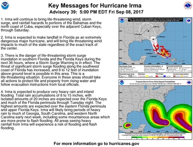
U.S. residents mainly receive authoritative warnings about emergencies and disasters from the following warning systems: the WEA service, the Emergency Alert System (EAS), and NOAA’s Weather Radio (NWR). These systems have been combined into the Integrated Public Alert and Warning System (IPAWS), which is administrated by FEMA (Wood, 2018). They can provide geo-targeted emergency warnings to users in disaster-affected areas. However, both geo-defining and geo-delivering steps in the current system provide hurricane warning messages that are not relevant to each household in the potentially affected area because of the coarse spatial scale of the warning zones (Wood, 2018). Specifically, the smallest warning scale is at the county scale and sub-county regions, such as cities and airports, but risk levels within a county can be extremely diverse during hurricanes (FCC, 2020). Hurricane information provided by the National Hurricane Center (NHC) and the National Weather Service (NWS) is the major factor in defining warning areas. Relevant environmental information—such as land use types and flood zones—has not yet been used, however, to generate warnings. As shown in Figure 1, the NWS generic hurricane advisory key message summary describes the general status of hurricane characteristics (e.g., wind speed, directions, and affected regions), and the potentially affected areas in the message are very coarse (such as Southeastern Florida) (NHC, n.d.a16). NWS posted these generalized messages on television, radio, and other public media as well as social media and other online platforms. Such messages do not always reflect the hurricane risk levels of local households (FCC, 2020; Gonzales et al., 2016).
Figure 1. National Hurricane Center Advisory for Hurricane Irma
Most existing studies have investigated how different elements of warning messages for hurricanes—such as their content, sources, and transmission channels—affect compliance (e.g., Morss et al., 201617; Bui, 201918). Warnings for hurricanes usually consist of basic information about the event and possible effects on people’s personal safety (Wei et al., 201419). Studies suggest that warnings should include features of a specific hurricane, including location and time of landfall, hurricane category, wind duration, general track of the hurricane (Villegas et al., 2013), and predicted impact on the built environment such as inundation by flood waters in residential areas, housing damage caused by storm winds, injury, job disruption, and service disruption (Wei et al., 2014). The guidance for the public’s response measures and the source of the warning messages have also been regarded as critical factors for effective warning (Wang et al., 2020). In current warning messages, the description and prediction of hurricane characteristics are determined by projected information of the hurricanes, but the dissemination process of warnings ignores the fact that the estimated effects on human life also depend on individuals’ living places.
Research relevant to delivery approaches of warnings has been insufficient, especially for geo-targeted warnings and their geo-defining process. Previous research has mainly focused on the precision and performance of the geo-delivering of warnings (Parker et al., 201520; Gonzales et al., 2016). Precision of geo-delivering measures the degree to which the population who should receive warnings did so. Performance evaluates the extent to which the warning messages were delivered to the population in time. The question of whether geo-targeted warnings can motivate residents to evacuate, however, has yet to be examined. This paper addresses that gap in current warning practices by proposing geo-targeted warnings, including environmental information (e.g., land use and flooding zoning) in the assessment of hurricane risks when designing warning messages.
Influence of Hurricane Risk Communication and Warnings on Resident Behaviors
To determine whether geo-targeted warnings can motivate evacuation (i.e., leave the warning zones), it is critical to understand how residents interpret warnings (Sutton & Kuligowski, 201921). The literature on both disaster risk communication and warnings is considered, as these topics have similar purposes of mitigating disaster’s negative impacts on human lives. Risk communication is the process by which individuals, groups, and institutions exchange information and opinions (National Research Council, 201322). Effective risk communication encourages the public to make life-saving decisions (Reynolds & Seeger 200523). A variety of factors influence residents’ behaviors after getting disaster risk information (Eiser et al., 201224; Huang et al., 201625), including previous experiences of risk judgment and the trustworthiness of different information sources (Halpern-Felsher et al., 200126; Eiser et al., 2012). Compared to risk communication, warnings contain direct risk information about hurricanes and are published by weather authorities (Anthony et al., 201427).
Studies show that individual and household evacuation decisions before hurricanes are influenced by several factors, including environmental conditions (e.g., the status of living places) (Hasan et al., 201128), the surrounding built environment (Sun et al., 2017), storm characteristics (Baker, 199129), demographic and other personal variables (Goodie et al., 201930), hurricane experience (Hasan et al., 2011; Matyas et al. 201131), family relationships (Nejat et al., 201632), and the content of warning information, such as the evacuation orders (Onggo et al., 201433). In the short term, warning content, which concerns information’s source and descriptions of the event, is the factor that can be managed by weather authorities (Huang et al., 2016). The forementioned factors affect people’s perception of and response to warnings. Residents are more likely to heed evacuation orders when the information they receive is accurate, consistent, and reflects their actual risk (Morss et al., 2016).
Research Gap
Although there is an array of studies on the (a) design of warning messages, (b) surveys on warnings’ effects on human behaviors, and (c) factors that impact evacuation decision-making, none have investigated the approach for geo-defining warning zones and their impact on evacuation or have compared the outcome with the real-world. We still do not know if geo-targeted warnings are more effective in motivating residents in high-risk areas to leave.
Research Design
Research Questions
Our three research questions are:
- How can we improve the geo-defining process of warning by considering both the built environment and characteristics of the imminent hurricane in affected areas?
- To what extent can the building-level geo-targeted warning messages motivate households to evacuate from high-risk areas before hurricanes?
- Is geo-targeted warning more effective than the general warning in motivating evacuation?
Study Site Description
We selected the residential areas of North Miami Beach, a city in Miami-Dade County, Florida, as our study site due to the increasing frequency and severity of recurrent tropical cyclones in the area compared to other urban sites in the United States (Environmental Protection Agency, n.d.34). North Miami Beach is a highly dense urban area with several storm-surge planning zones, yet limited evacuation routes—which could lead to severe traffic jams during mass evacuation situations (Sadri, 201535). Thus, it is crucial to deliver warnings including hurricane risks at finer spatial scales to inform residents and motivate evacuation in high-risk areas, while limiting mass exodus from areas where it is safe to shelter in place.
Specifically, we examined residents’ evacuation decisions in response to the hurricane warnings issued for Hurricane Irma between September 7, 2017, and September 14, 2017, during which the hurricane warning was issued at 11 p.m. on September 7, 2017. South Floridians began paying very close attention to Irma’s forecast up to a week or more before landfall in South Florida (Wong et al., 201836). Hurricane Irma made two continental U.S. landfalls in Florida with maximum sustained winds of 130 MPH (category 4) at 9:10 AM EDT on Sunday, September 10 at Cudjoe Key, and maximum sustained winds of 115 MPH (category 3) at 3:35 PM EDT that same day at Marco Island.
Data, Methods, and Procedures
The procedure of this research is shown in Figure 2 and described in the following subsections.
Figure 2. Research Framework

Designing Geo-Targeted Hurricane Warning Scenario
To specify the hurricane risks of buildings in our studied area, we used these existing datasets: (a) hurricane data from NOAA and ARA (ARA, n.d.37; NHC, n.d.b38), (b) flooding risk data from the First Street Foundation (n.d.39), and (c) land use data from the University of Florida GeoPlan Center (n.d.40). Data from these sources for the North Miami Beach are shown in Figure 3.
Figure 3. Building Hurricane Risks in North Miami Beach
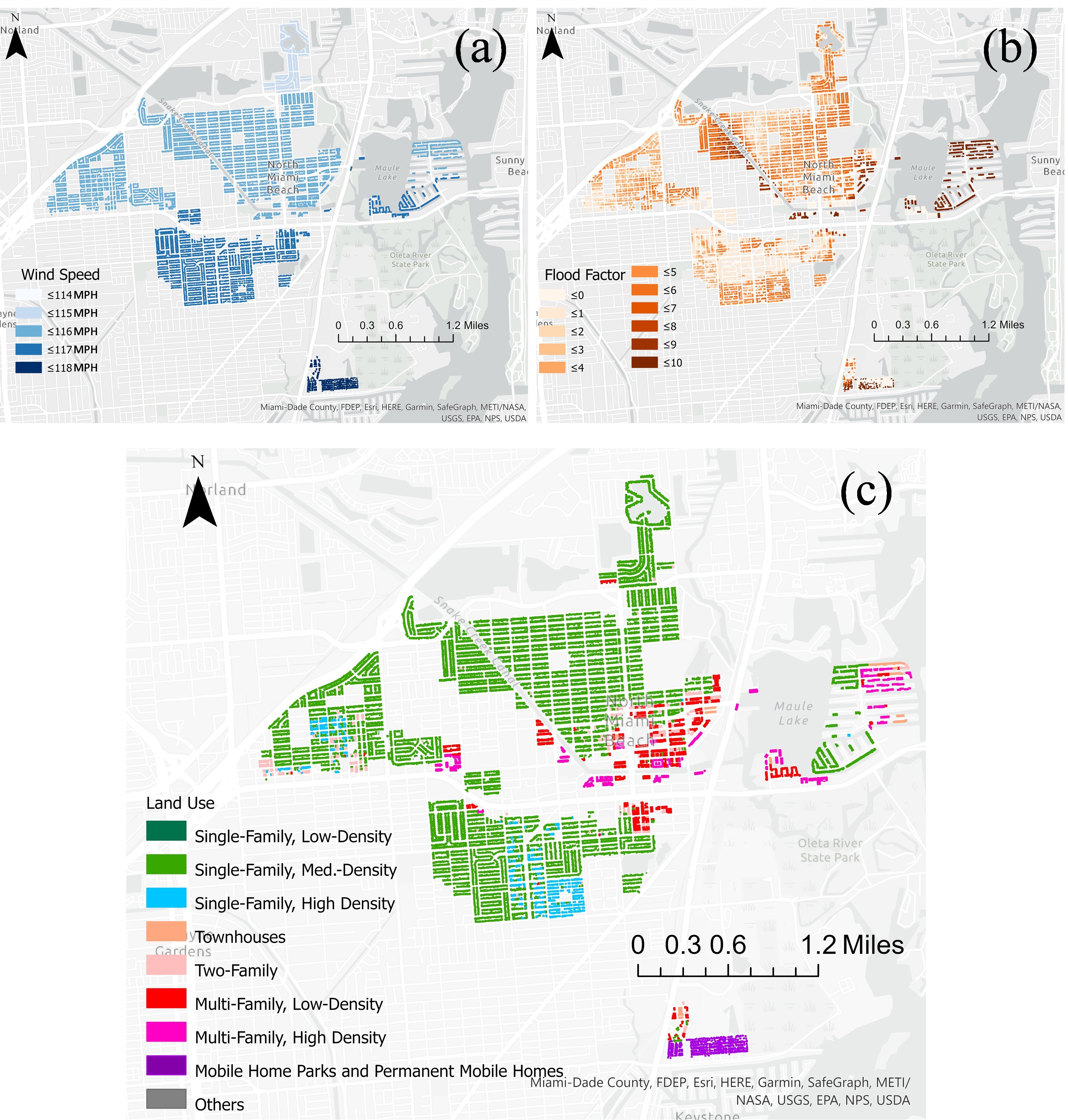
The hurricane data shows the forecasted maximum wind speed (WS) in the census blocks, which was updated over time based on the changing forecast of hurricane characteristics and indicated the direct impact of Hurricane Irma on local households. The impact of the hurricane was more severe if the wind speed in the local census block was higher.
To identify the flooding risks of properties, we utilized the Flood Factor (FF) from First Street Foundation, which was an integrated indicator that ranked the buildings’ flooding risks based on lowest floor elevation, FEMA flooding zoning, and the potential flood types across rainfall pluvial flooding, riverine flooding, and coastal surge flooding. (First Street Foundation, n.d.). The value of the Flood Factor ranges from 0 to 10, representing the potential impact level that specific buildings may receive in flooding events (First Street Foundation, n.d.). The data of the Flood Factor was at the building level.
The land use data (LU) described the building types and population density at the parcel level. Specifically, residential buildings tended to be less resistant to hurricanes because their structures were generally light-frame wood in United States (Li & Ellingwood, 200641), and housing types with higher population density tended to bare higher-level economic loss and slower recoveries (Hamideh et al., 202142). Consequently, residential areas, especially the high-density residential zones, were more vulnerable and faced higher level hurricane risks (Bakkensen & Mendelsohn, 201643).
For our purposes, we standardized the values from these datasets into a range from 0 to 1. The standardization was achieved by deducting the lowest value and then dividing the value by the standard deviation of the whole dataset. The data conditions are shown in Table 1.
Table 1. Datasets Used for Hurricane Risk Determination
| Dataset | Range |
| Wind Speed | 114 to 118 mph |
| Land Use | Ranked value from 1 to 7. Mobile home (7), multi-family (high density) (6), multi-family (low density) (5), two-family (4), single-family (high density) (3), single-family (median density) (2), single-family (low density) (1) |
| Flood Factor | 0 to 10. |
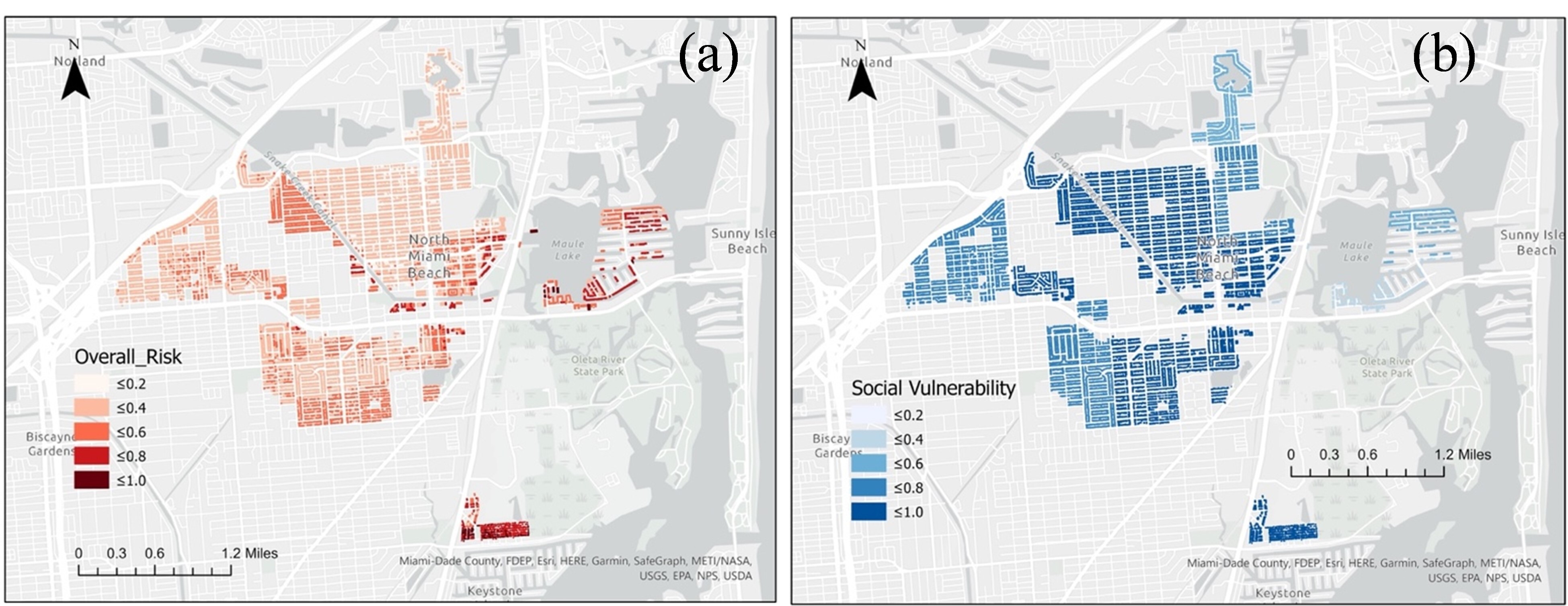
To estimate the hurricane risk level for buildings, we used Equation 1 (see below), in which Risk (X) is function of Wind Speed (WS), Land Use (LU), and Flood Factor (FF). We primarily regarded the wind speed, land use types, and flooding risks as having the same weights on affecting the households’ hurricane risk levels. Figure 4(a) shows the hurricane risk levels of residential buildings in our study area resulting from Equation 1.
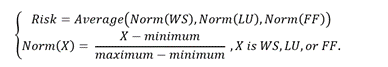
Figure 4. Comparison of Building Hurricane Risk and Social Vulnerability in North Miami Beach
Modeling Agent Decision-Making Process
To simulate evacuation decision-making, we utilized virtual agents to represent the local households. Each residential building in the study area was assigned with one virtual agent (representing a household). The social vulnerability level of virtual agents was extracted from the Centers for Disease Control and Prevention’s [CDC] Social Vulnerability Index (Bakkensen et al., 201644; CDC, 201845), which reflected how resilient a community was when confronted by disaster events. We assigned the value of the social vulnerability index to the agents as their disaster vulnerability based on the 44 local census blocks. The geographic distribution of agents’ social vulnerability in North Miami Beach is shown above in Figure 4(b). The range of social vulnerability was from 0 to 1.
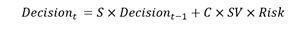
To estimate the extent to which geo-targeted hurricane warnings motivate households who are under high-level hurricane risks to evacuate, we adapted Decision Field Theory (Busemeyer & Diederich, 200246) to construct Equation 2 (Gao & Wang, 202147). Equation 2 uses the following elements to simulate the evacuation decision (Decisiont) of virtual agents: the previous decision (Decisiont-1), the Stability matrix (S) which represents the lingering effects of previous decision preference and the effects of interaction among options, the identity matrix (C), the social vulnerability of virtual agents (SV), and the risk level in the warning messages (Risk).
Before the simulation, the virtual agents were assigned with no intention of evacuation. On the first day of the simulation process (September 7), the agents received warning messages about the hurricane risks of their surrounding environment, and they conducted evacuation decision-making over the following days until they decided to evacuate. In the simulation process, agents fully adopted the decisions from the previous round of the simulation, (i.e., the evacuation decisions on the previous day). Once the residents decided to evacuate, we assumed that their decisions remain until the end of the simulation.
Evaluating Simulation Outcomes With Real-World Mobility Data
To evaluate the extent to which our targeted warning advanced the generic and non-targeted hurricane warnings, we compared the simulated evacuation scenario with the real-world scenario that was based on mobility data provided by a third party. The data were collected through smartphones consisting of columns of an anonymized identifier, latitude, longitude, and the corresponding timestamp. We processed the raw data by performing the stay-point algorithm (Li et al., 200848) that removed passing-by points on users’ raw GPS data, and 50 meters and 5 minutes were the spatial and temporal thresholds, respectively. We then implemented a hierarchical clustering algorithm with complete linkage (Johnson, 196749) across each user’s weekday evening locations to obtain all spatially distinct stay regions, and each region had a maximum diameter of 50 meters with a minimum stay duration of 5 minutes. Finally, we assigned the regions with the most significant stay duration as the tentative home locations for the users. We cross-validated the users’ home locations in different weeks using a threshold that the user needed to be in the home for over half of the study period. We finally used GPS records of 758 individuals' stay points whose home locations were within the boundary of the North Miami Beach region throughout Hurricane Irma. We then used one week of these users' stay points after receiving the warning messages regarding Irma's landfall to infer the user's evacuation status at each hour interval. Referring to the detection measures of evacuation behaviors in Deng et al. (202150), which regarded a person as evacuated if they left the home locations for three consecutive days, we considered one user’s status as “evacuated” on a specific date if all stay points of this user were not located within the home census block.
Ethical Considerations
In this study, we analyzed publicly available spatial datasets. Mobility data is from anonymized and voluntarily opted-in users. No private and personal information is available. Also, results were only reported at an aggregated level (e.g., block group level).
Findings
We compared the simulation outcomes under the tested geo-targeted warning with the human mobility data in the real world under the general warning to evaluate its effectiveness. The latter was calculated by the proportion of the real population who evacuated since the publication of hurricane warnings on September 7, 2017 (the first date for our simulation). Although the evacuation decision-making process was designed based on real-world survey data, the simulated agents were still not real-world residents. The evacuation decisions of virtual agents cannot be compared with the individual users’ movements directly. To evaluate the impact of the geo-targeted hurricane warnings on motivating evacuation, we aggregated the virtual agents’ evacuation decisions and real-world human evacuation statuses into the census-block level for comparison, shown in Figure 5 as the percentage of local households or virtual households in the simulation deciding to evacuate from their home census block. The comparison result shows the overall evacuation conditions of virtual agents and real-world residents in the case area.
Figure 5. Evacuation Rates by Census Block in Simulated and Real-World Scenarios in North Miami Beach
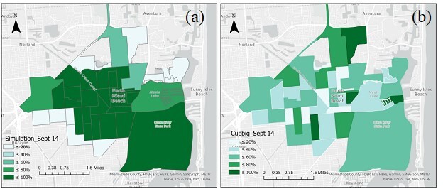
Table 2 lists the census blocks where the building-level hurricane risks were higher than 0.8 and the proportions of households of evacuation decisions in both simulation scenario and the real world. The targeted communication would be regarded as more effective if the proportion of evacuated virtual agents was much larger than real-world residents in high-risk regions. Under the geo-targeted hurricane warnings, more than 80% of the virtual agents decided to evacuate from the southeastern area of North Miami Beach, and 80% to 100% of the households of census blocks located next to rivers and lakes were also motivated to evacuate. This may be because these households want to avoid being impacted by the flooding from surrounding water bodies. Comparatively, residents in these high-risk regions were not identified to evacuate under the real-world warning scenario (especially the census blocks listed in Table 2), while the residents in the northern area were more likely (more than 80% of local population) to evacuate, even though they were not under high-level risks.
Table 2. High Building Risk Census Blocks and Evacuation Rates in Simulated and Real-World Scenarios
| Census Block ID | Simulated Scenario | Real world |
| 120860001271 | 67% | 60% |
| 120860001272 | 73% | 45% |
| 120860001281 | 70% | 26% |
| 120860002122 | 93% | 83% |
| 120860002133 | 89% | 55% |
| 120860002142 | 91% | 38% |
| 120860002143 | 90% | 18% |
Additionally, according to the social vulnerability map of Figure 4(b), the geo-targeted hurricane warnings motivated the population who were much socially vulnerable to evacuate. This suggests that by considering the characteristics of local land use and flooding risks, geo-targeted warning messages can more accurately inform the populations in census blocks with higher social vulnerability regarding their risk during imminent hurricane events. By identifying the specific hurricane risk at their residential location, these messages appear to assist vulnerable households in making more appropriate decisions, including evacuating. In contrast, under the real-world generic warnings, the evacuation rate in high-vulnerability areas was much lower. Instead, most evacuees during the actual scenario were from low-vulnerability census blocks.
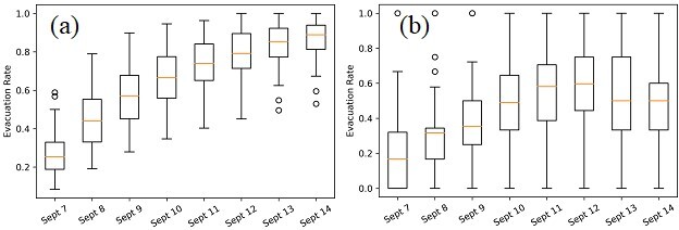
We also plotted box plots to illustrate the evacuation rates of census blocks under the scenarios of geo-targeted hurricane warnings and real-world generic warnings (Figure 6). In the case period, the average evacuation rate had a similar changing trend under both scenarios: rapidly increased in the first six days. This trend meant that after the warning messages were disseminated, both the virtual agents and the real-world residents gradually decided to evacuate from their home locations, and the increasing speed of the population who decided to evacuate was high. However, (i) the increasing speed of the average evacuation rate and (ii) the range of evacuation rate among the census blocks were much higher under the geo-targeted hurricane warnings than the generic warning scenario. In other words, under the geo-targeted hurricane warning scenario, households in high-risk areas decided to evacuate much sooner, and they were more likely to avoid the impact of Hurricane Irma. Comparatively, the real-world generic warnings may have led residents to misperceive the hurricane risk, resulting in delayed evacuation. On September 13 and 14, the local population was observed returning to their home locations under the real-world warning scenario. Such a situation was not reflected in our simulation, as we only simulated the virtual households’ decision-making process regarding whether they should evacuate, thus the decision-making for other behaviors (e.g., returning home) cannot be shown in our simulation outcomes. Overall, by considering the hurricane wind speed, land use types, and flooding risks in the design of hurricane warning messages, the geo-targeted hurricane warnings can better motivate the households in high-risk areas in North Miami Beach to evacuate in a timelier manner.
Figure 6. Box Plots of Census Block Evacuation Rates in Simulated and Real-World Scenarios in North Miami Beach
Discussion
This interdisciplinary research measured hurricane risk levels of local households based on high-resolution environmental datasets. We examined the effectiveness of geo-targeted warning messaging in motivating evacuation behaviors before a hurricane. Comparatively, the geo-targeted hurricane warnings can better convey the risk level of high-speed wind and potential flooding events for specific households than existing generic warnings, which deliver the same message to all the residents in a coarse spatial region. The research outcomes also suggest that building-level geo-targeted warnings can motivate households in high-risk areas to evacuate before a destructive hurricane (such as Category-5 Hurricane Irma). Additionally, residents decided to evacuate much earlier under the geo-targeted warnings than the generic warning scenario.
This research advances the existing disaster and crisis communication body of knowledge in the following ways: First, previous studies measuring hurricane risks lacked sufficient consideration of environmental factors but mainly focused on the hurricane features at coarse spatial scales, such as the hurricane track and wind speed in the county or census tract level (FCC, 2020; Gao & Wang, 2021; Villegas et al., 2013). We included the land use types and flooding risks of households’ buildings and located parcels, with which the hurricane risks can be measured more accurately, and the delivered messages can better reflect risks faced by each household. To the best of our knowledge, we were also among the first to evaluate the effectiveness of geo-targeted hurricane warnings on motivating evacuation among high-risk households by comparing the impact of geo-targeted warnings with the real-world mobility data, which represented the public’s response to the general hurricane warnings. Second, this study utilized agent-based modeling to simulate households’ evacuation decision-making under the geo-targeted hurricane warnings and evaluate the communication performance by comparing it with the human mobility under the real-world generic warnings.
This study has a few limitations that will be addressed in future work. First, the current design of geo-targeted hurricane warnings lacked sufficient information about building structure and local infrastructure vulnerability to hurricane hazards. Currently, we do not have sufficient data for quantitatively specifying the difference between the impacts of environmental factors (i.e., land use types) and meteorological features (i.e., wind and flooding) on the households’ hurricane risk levels, and we temporarily treat these features as equally important when evaluating households’ hurricane risk levels. Our future study will include datasets on the building-level structural information when assessing the potential impacts of hurricane hazards to specific buildings, and the influence of different factors on the risk level will also be specified. Second, our design of households’ evacuation decision-making may not fully capture the real-world decision-making process, as we mainly considered the influence of social vulnerability and warning messages on the households’ evacuation decisions. In our future work, we will refine the simulation of households’ evacuation decision-making process based on the up-to-date decision-making models and include more factors that contribute to households’ decision-making. Third, in addition to evacuation, other protective measures can also be adopted by at-risk populations, such as taking refuge in small interior rooms, strengthening the exterior protection components of the house, and setting flood boards around the house (NWS, n.d.51). Our future work will model the decision-making process of households regarding multiple protective measures at different times after receiving the warning messages. Additionally, we will refine the identification of the at-risk population’s evacuation behaviors in the real world, such as refining the criteria regarding whether an individual has evacuated from the home location based on the individual’s recorded locations.
Our future study will develop a framework of disaster risk measurement that includes more comprehensive and detailed information regarding the built environment. We also aim to design the simulation model to better capture residents’ decision-making processes and behavioral patterns by including more detailed processes and critical factors of evacuation decision-making. Additionally, we will specify the process of information dissemination, such as (i) designing the text features of warning messages to help residents perceive the disaster risks, and (ii) designing the strategies about how the disaster managers assign targeted messages to the population in need. Another limitation is that we only examined the performance of geo-targeted hurricane warnings in one case area. The results may not be applied to other regions directly. We will include multiple cases in future studies to assess the effectiveness of geo-targeted hurricane warnings in general.
Conclusions
This project combined knowledge from risk communication, meteorology, geography, urban planning, and transportation engineering. This interdisciplinary research explored whether the geo-targeted hurricane warning messages can motivate the public to conduct suitable response behaviors. An empirical study that uses high-resolution human mobility data is an innovative approach to understanding the effect of warnings on individuals’ mobility patterns. The research methodology can also be utilized in designing and evaluating geo-targeted warning messages in response to other extreme events such as natural hazards, climate risks, and pandemics.
Florida can experience hurricanes during the Atlantic hurricane season (June to November) every year. It is urgent and time-critical that we understand the influences of different warning strategies on people’s evacuation decisions described in this report. The research outcomes can inform local NWS forecast offices (e.g., in Miami, FL) and disaster responders (e.g., city managers) on how to measure personal risk level and design targeted warning messages based on multi-sourced data about disasters and the environment, and understand which warning strategy (e.g. geo-targeted warning or general warning) is more effective in terms of motivating evacuations over time. Additionally, this research highlights the critical role of building-scale environment information (e.g., building flooding factor) towards extreme hazards when measuring residents’ confronted risks. The research outcomes indicate the necessity of integrating human-environment-hazard factors in planning for disaster preparedness and improving community resilience to natural hazards. More effective risk communication and warnings can save more lives and mitigate damages caused by hurricanes, the storm surge, and flooding. The more targeted warning can also motivate residents to take necessary hazard prevention actions and to evacuate if necessary. The research outcomes will provide a basis for a potential pilot study in collaboration with the local NWS to implement geo-targeted warnings before a future hurricane in Florida. The geo-targeted warning messages can also be developed for distinct types of hazards that have notable impacts on communities across the country, such as tornados, wildfires, and inland flooding. Local disaster managers can specify the environmental features that contribute to local households’ risk levels (such as buildings’ structural characteristics, the land use land cover surrounding local households, temperature/humidity, and other meteorological indicators, and the features of surrounding water bodies) and provide more targeted and tailored warning messages to motivate proactive prevention measures in advance of disaster events.
References
-
National Oceanic and Atmospheric Administration. (2021). Billion-Dollar Weather and Climate Disasters: Overview. https://www.ncdc.noaa.gov/billions/ ↩
-
Kakareko, G., Jung, S., & Vanli, O. A. (2020). Hurricane risk analysis of the residential structures located in Florida. Sustainable and Resilient Infrastructure, 5(6), 395-409. https://doi.org/10.1080/23789689.2019.1632599 ↩
-
Yao, F., & Wang, Y. (2020). Towards resilient and smart cities: A real-time urban analytical and geo-visual system for social media streaming data. Sustainable Cities and Society, 63, 102448. https://doi.org/10.1016/j.scs.2020.102448 ↩
-
Villegas, J., Matyas, C., Srinivasan, S., Cahyanto, I., Thapa, B., & Pennington-Gray, L. (2013). Cognitive and affective responses of Florida tourists after exposure to hurricane warning messages. Natural Hazards, 66(1), 97-116. https://doi.org/10.1007/s11069-012-0119-3 ↩
-
Wang, Y., Hao, H., & Platt, L. S. (2021). Examining risk and crisis communications of government agencies and stakeholders during early-stages of COVID-19 on Twitter. Computers in Human Behavior, 114, 106568. https://doi.org/10.1016/j.chb.2020.106568 ↩
-
Zhang, L., Li, H., & Chen, K. (2020). Effective risk communication for public health emergency: reflection on the COVID-19 (2019-nCoV) outbreak in Wuhan, China. Healthcare, 8(1), 64. https://doi.org/10.3390/healthcare8010064 ↩
-
Zommers, Z., & Singh, A. (2014). Reducing disaster: early warning systems for climate change. Springer. https://doi.org/10.1007/978-94-017-8598-3 ↩
-
Frewer, L. (2004). The public and effective risk communication. Toxicology Letters, 149(1-3), 391-397. https://doi.org/10.1016/j.toxlet.2003.12.049 ↩
-
Federal Communications Commission. (2020). Wireless Emergency Alerts (WEA). https://www.fcc.gov/consumers/guides/wireless-emergency-alerts-wea ↩
-
Gonzales, D., Kraus, L., Osburg, J., Shelton, S.R., Woods, D. (2016). Geo-targeting Performance of Wireless Emergency Alerts in Imminent Threat Scenarios: Volume 1: Tornado Warnings. United States Department of Homeland Security. https://www.dhs.gov/sites/default/files/publications/Rand_WEA-Final%20Report-VOL1-8-26-16-508C.pdf ↩
-
Wood, M. (2018). Geotargeted alerts and warnings. International Encyclopedia of Geography: People, the Earth, Environment and Technology. https://doi.org/10.1002/9781118786352.wbieg1150.pub2 ↩
-
Sun, D., Kang, J. E., Batta, R., & Song, Y. (2017). Optimization of evacuation warnings prior to a hurricane disaster. Sustainability, 9(11), 2152. https://doi.org/10.3390/su9112152 ↩
-
Hossain, M. K., & Meng, Q. (2020). A fine-scale spatial analytics of the assessment and mapping of buildings and population at different risk levels of the urban flood. Land Use Policy, 99, 104829. https://doi.org/10.1016/j.landusepol.2020.104829 ↩
-
Liu, H., Behr, J. G., & Diaz, R. (2016). Population vulnerability to storm surge flooding in coastal Virginia, USA. Integrated Environmental Assessment and Management, 12(3), 500-509. https://doi.org/10.1002/ieam.1705 ↩
-
Yang, D., Yang, A., Qiu, H., Zhou, Y., Herrero, H., Fu, C. S., ... & Tang, J. (2019). A citizen-contributed GIS approach for evaluating the impacts of land use on hurricane-Harvey-induced flooding in Houston area. Land, 8(2), 25. https://doi.org/10.3390/land8020025 ↩
-
National Hurricane Center. (n.d.a). Hurricane IRMA advisory archive. [Data set]. Retrieved January 3, 2022, from https://www.nhc.noaa.gov/archive/2017/IRMA.shtml? ↩
-
Morss, R. E., Demuth, J. L., Lazo, J. K., Dickinson, K., Lazrus, H., & Morrow, B. H. (2016). Understanding public hurricane evacuation decisions and responses to forecast and warning messages. Weather and Forecasting, 31(2), 395-417. https://doi.org/10.1175/WAF-D-15-0066.1 ↩
-
Bui, L. (2019). Social media, rumors, and hurricane warning systems in Puerto Rico.[Conference paper]. Hawaii International Conference on System Science. http://hdl.handle.net/10125/59704 ↩
-
Wei, H.L., Lindell, M.K., Prater, C.S. (2014). “Certain death” from storm surge: a comparative study of household responses to warnings about Hurricanes Rita and Ike. Weather, Climate, and Society, 6(4), 425-433. https://doi.org/10.1175/WCAS-D-13-00074.1 ↩
-
Parker, A.M., Jackson, B.A., Martinez, A.R., Sanchez, R., Shelton, S.R., Osburg, J. (2015). Exploring the effect of the diffusion of geo-targeted emergency alerts: the application of agent-based modeling to understanding the spread of messages from the wireless emergency alerts system. United States Department of Homeland Security. https://www.dhs.gov/sites/default/files/publications/WEA%20-%20Exploring%20the%20Effect%20of%20the%20Diffusion%20of%20Geo-Targeted%20Emergency%20Alerts.pdf ↩
-
Sutton, J., Kuligowski, E.D. (2019). Alerts and warnings on short messaging channels: Guidance from an expert panel process. Natural Hazards Review 20(2), 04019002. https://doi.org/10.1061/(ASCE)NH.1527-6996.0000324 ↩
-
National Research Council (2013). Geotargeted alerts and warnings: Report of a workshop on current knowledge and research gaps. https://doi.org/10.17226/18414 ↩
-
Reynolds, B., & Seeger, M. W. (2005). Crisis and emergency risk communication as an integrative model. Journal of Health Communication, 10(1), 43-55. https://doi.org/10.1080/10810730590904571 ↩
-
Eiser, J. R., Bostrom, A., Burton, I., Johnston, D. M., McClure, J., Paton, D., van der Pligt, J., White, M. P. (2012). Risk interpretation and action: A conceptual framework for responses to natural hazards. International Journal of Disaster Risk Reduction, 1, 5-16. https://doi.org/10.1016/j.ijdrr.2012.05.002 ↩
-
Huang, S.K., Lindell, M.K., & Prater, C.S. (2016). Who leaves and who stays? A review and statistical meta-analysis of hurricane evacuation studies. Environment and Behavior, 48(8), 991-1029. https://doi.org/10.1177/0013916515578485 ↩
-
Halpern-Felsher, B. L., Millstein, S. G., Ellen, J. M., Adler, N. E., Tschann, J. M., & Biehl, M. (2001). The role of behavioral experience in judging risks. Health Psychology, 20(2), 120. https://doi.org/10.1037/0278-6133.20.2.120 ↩
-
Anthony, K. E., Cowden-Hodgson, K. R., Dan O'Hair, H., Heath, R. L., & Eosco, G. M. (2014). Complexities in communication and collaboration in the hurricane warning system. Communication Studies, 65(5), 468-483. https://doi.org/10.1080/10510974.2014.957785 ↩
-
Hasan, S., Ukkusuri, S., Gladwin, H., & Murray-Tuite, P. (2011). Behavioral model to understand household-level hurricane evacuation decision making. Journal of Transportation Engineering, 137(5), 341-348. https://doi.org/10.1061/(ASCE)TE.1943-5436.0000223 ↩
-
Baker, E. J. (1991). Hurricane evacuation behavior. International Journal of Mass Emergencies and Disasters, 9(2), 287-310. ↩
-
Goodie, A. S., Sankar, A. R., & Doshi, P. (2019). Experience, risk, warnings, and demographics: Predictors of evacuation decisions in Hurricanes Harvey and Irma. International Journal of Disaster Risk Reduction, 41, 101320. https://doi.org/10.1016/j.ijdrr.2019.101320 ↩
-
Matyas, C., Srinivasan, S., Cahyanto, I., Thapa, B., Pennington-Gray, L., & Villegas, J. (2011). Risk perception and evacuation decisions of Florida tourists under hurricane threats: A stated preference analysis. Natural Hazards, 59(2), 871-890. https://doi.org/10.1007/s11069-011-9801-0 ↩
-
Nejat, A., Cong, Z., Liang, D.A. (2016). Family structures, relationships, and housing recovery decisions after Hurricane Sandy. Buildings 6(2),16. https://doi.org/10.3390/buildings6020014 ↩
-
Onggo, B.S., Busby, J., Liu, Y. (2014). Using agent-based simulation to analyze the effect of broadcast and narrowcast on public perception: a case in social risk amplification. [Conference session]. Proceedings of the Winter Simulation Conference. https://ieeexplore.ieee.org/document/7019899 ↩
-
Environmental Protection Agency. (n.d.). Climate Change Indicators: Coastal Flooding. https://www.epa.gov/climate-indicators/climate-change-indicators-coastal-flooding#%20 ↩
-
Sadri, A. M., Ukkusuri, S. V., Murray-Tuite, P., & Gladwin, H. (2015). Hurricane evacuation route choice of major bridges in Miami Beach, Florida. Transportation Research Record, 2532(1), 164-173. https://doi.org/10.3141/2532-18 ↩
-
Wong, S., Shaheen, S., & Walker, J. (2018). Understanding evacuee behavior: a case study of hurricane Irma. University of California Berkeley: Transportation Sustainability Research Center. https://escholarship.org/uc/item/9370z127 ↩
-
Applied Research Associates. (n.d.). HurLoss hurricane catastrophe model. [Data set]. Retrieved February 13, 2022, from https://www.ara.com/hurloss/ ↩
-
National Hurricane Center. (n.d.b). NHC Data in GIS Formats. [Data set]. Retrieved February 17, 2021, from https://www.nhc.noaa.gov/gis/ ↩
-
First Street Foundation. (n.d.). Flood Factor. [Data set]. Retrieved April 28, 2021, from https://firststreet.org/flood-factor/ ↩
-
University of Florida GeoPlan Center. (n.d.). FGDL Metadata Explorer. [Data set]. Retrieved February 17, 2021, from https://www.fgdl.org/metadataexplorer/explorer.jsp ↩
-
Li, Y., & Ellingwood, B. R. (2006). Hurricane damage to residential construction in the US: Importance of uncertainty modeling in risk assessment. Engineering Structures, 28(7), 1009-1018. https://doi.org/10.1016/j.engstruct.2005.11.005 ↩
-
Hamideh, S., Peacock, W. G., & Van Zandt, S. (2021). Housing type matters for pace of recovery: Evidence from Hurricane Ike. International Journal of Disaster Risk Reduction, 57, 102149. https://doi.org/10.1016/j.ijdrr.2021.102149 ↩
-
Bakkensen, L. A., & Mendelsohn, R. O. (2016). Risk and adaptation: Evidence from global hurricane damages and fatalities. Journal of the Association of Environmental and Resource Economists, 3(3), 555-587. https://doi.org/10.1086/685908 ↩
-
Bakkensen, L.A., Fox-Lent, C., Read, L.K., & Linkov, I. (2016). Validating resilience and vulnerability Indices in the context of natural disasters. Risk Analysis, 37(5). https://doi.org/10.1111/risa.12677 ↩
-
Centers for Disease Control and Prevention. (2018). CDC/ATSDR Social Vulnerability Index. [Data set]. https://www.atsdr.cdc.gov/placeandhealth/svi/index.html ↩
-
Busemeyer, J. R., & Diederich, A. (2002). Survey of decision field theory. Mathematical Social Sciences, 43(3), 345-370. https://doi.org/10.1016/S0165-4896(02)00016-1 ↩
-
Gao, S., & Wang, Y. (2021). Assessing the impact of geo-targeted warning messages on residents’ evacuation decisions before a hurricane using agent-based modeling. Natural Hazards, 1-24. https://doi.org/10.1007/s11069-021-04576-1 ↩
-
Li, Q., Zheng, Y., Xie, X., Chen, Y., Liu, W., & Ma, W. Y. (2008). Mining user similarity based on location history. [Conference session]. 16th Assocation for Computng Machinery SIGSPATIAL International Conference on Advances in Geographic Information Systems, New York, NY. https://doi.org/10.1145/1463434.1463477 ↩
-
Johnson, S. C. (1967). Hierarchical clustering schemes. Psychometrika, 32(3), 241-254. https://doi.org/10.1007/BF02289588 ↩
-
Deng, H., Aldrich, D. P., Danziger, M. M., Gao, J., Phillips, N. E., Cornelius, S. P., & Wang, Q. R. (2021). High-resolution human mobility data reveal race and wealth disparities in disaster evacuation patterns. Humanities and Social Sciences Communications, 8(1), 1-8. https://doi.org/10.1057/s41599-021-00824-8 ↩
-
National Weather Services. (n.d.). Actions to Take When a Tropical Storm or Hurricane Threatens. Retrieved December 30, 2021, from https://www.weather.gov/safety/hurricane-action ↩
Goa, S., Wang, Y., Wang R. Q., & Matyas, C. J. (2022). Household-Targeted Hurricane Warnings for Effective Evacuation (Natural Hazards Center Weather Ready Research Report Series, Report 3). Natural Hazards Center, University of Colorado Boulder. https://hazards.colorado.edu/weather-ready-research/household-targeted-hurricane-warnings-for-effective-evacuation