Hurricane Harvey, Mobile Home Parks, and Flood Risk
Abstract
Mobile home parks are one of the largest sources of affordable housing in the United States. Mobile home parks are frequently affected by disasters, but the specific dimensions of their disaster vulnerability have not been comprehensively studied. Texas, Hurricane Harvey, and the Houston metropolitan area present a unique nexus to study the vulnerability of mobile home parks to disasters, across different geographic, demographic, and governance contexts. In this Quick Response study, and as groundwork for a larger study on mobile home park disaster vulnerability, we created an inventory of all mobile home parks in the Houston metropolitan statistical area, and predicted which ones were likely to have suffered damage from flooding during Hurricane Harvey. We then visited 25 mobile home parks to test our methodology, and interviewed local experts about the hurricane and ongoing housing recovery in the city. We found that our methodology for locating individual parks was accurate, but is likely undercounting the total population of existing parks. We also found that our methodology for estimating flooding was insufficient for predicting flood damage in mobile home parks. For parks that did suffer damage, residents report diverse experiences with the availability and sufficiency of recovery resources. Last, we found that mobile home parks have been mostly absent from local stakeholders’ conversations about post-disaster housing recovery. These findings have important implications for our future research on the differential pace and trajectory of recovery for mobile home parks in the Houston area.
Overview
Affordable housing is an essential part of healthy and resilient communities. Mobile home parks (MHPs) are one of the largest sources of affordable housing in the United States, home to 2.9 million households. MHPs predominantly house low-income and socially vulnerable populations and are frequently exposed to natural hazards and disasters. Mobile home parks are unique compared to other forms of housing because of their mixed land tenure, private ownership, and legal and regulatory treatment. How do these unique characteristics contribute to the vulnerability of mobile home parks and their residents to disasters?
Studies have documented the physical vulnerability of mobile homes to natural hazards, and the disproportionate exposure of mobile home parks to extreme events like floods and tornadoes (Chaney and Weaver 20101; Kellner and Niyogi 20142; Pierce Gabbe and Gonzalez 20183). A small number of studies, including our previous work on the 2013 Colorado floods, have shown that mobile home park residents also encounter unique barriers during the disaster recovery process (Rumbach Makarewicz and Nemeth 20164; Rumbach and Makarewicz 20165). However, no current studies have looked comprehensively at the factors and mechanisms that contribute to mobile home park vulnerability before and after disasters. It is vital for disaster researchers to understand why this unique housing type is differentially exposed to extreme events, how housing characteristics in mobile home parks contribute to the uneven recovery of already socially vulnerable households, and what factors and mechanisms contribute to disparities in the recovery process.
Hurricane Harvey and the nine-county Houston Metropolitan Statistical Area (MSA) present a unique nexus to study the vulnerability of MHPs across different geographic, demographic, and governance contexts. Texas is the state with the second largest total number of mobile homes in the United States, and Harris County, where Houston is located, has the largest share of mobile homes in the state (Sullivan 2017a6). Anecdotal accounts suggest that thousands of mobile homes were damaged or destroyed by the hurricane and subsequent flooding, across a large geographical area and in diverse political, economic, and geographical contexts. The post-disaster recovery in the Houston metropolitan area is thus a unique opportunity to develop a large-scale, comparative study of disaster recovery specific to mobile home park housing.
Research Goal and Questions
The goal of this Quick Response study is to quantify the exposure of mobile home parks to Hurricane Harvey flooding in the Houston MSA and gauge park residents’ initial experience with recovery in preparation for a broader mixed-method study of MHP disaster recovery over time. To this end, we ask the following research questions:
- How many mobile home parks were located in the Houston MSA prior to Hurricane Harvey, and what was their location?
- How many mobile home parks in the Houston MSA were likely to have flooded during Hurricane Harvey?
- In mobile home parks flooded by Hurricane Harvey, what unique challenges did residents face in their early recovery?
The study will help to establish a foundation for a long-term comparative study of mobile home park recovery in post-Harvey Houston.
Methodology
To answer these research questions, we first needed to establish a population frame, or a comprehensive listing of every mobile home park in the Houston metropolitan area. One of the key challenges for conducting research on mobile home parks is their relative invisibility; in many states, mobile homes are registered as motor vehicles rather than as housing. Mobile home parks are also private businesses and typically have only a single address, regardless of the number of mobile homes they contain (see Figure 1).
Like most cities in the United States, Houston does not maintain a separate record of mobile home park locations or their characteristics, and neither does the state of Texas. Thus, we employed a mixed-method geospatial and qualitative methodology. We first used geospatial analysis to locate and document flooded MHPs in the Houston MSA and then conducted field visits and exploratory qualitative interviews to understand the extent and impact of flooding.
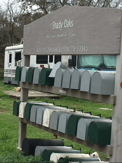
Figure 1: Mailboxes for mobile home park residents at a single address.
Quick Response Grant Geospatial Analysis
To map the location of mobile home parks, we used a methodology documented by Sullivan (2017b)7 that relies on Texas’s publicly available appraisal district land records. We collected tax data for each land parcel in the Houston MSA in 2015, the most recent year prior to Harvey when complete records were available. We then identified parcels coded as mobile home parks within the appraisal district land use classifications. We assigned them unique identifiers and combined them into a single dataset. This preliminary dataset identifies 1,029 parcels as mobile home parks (see Map 1).
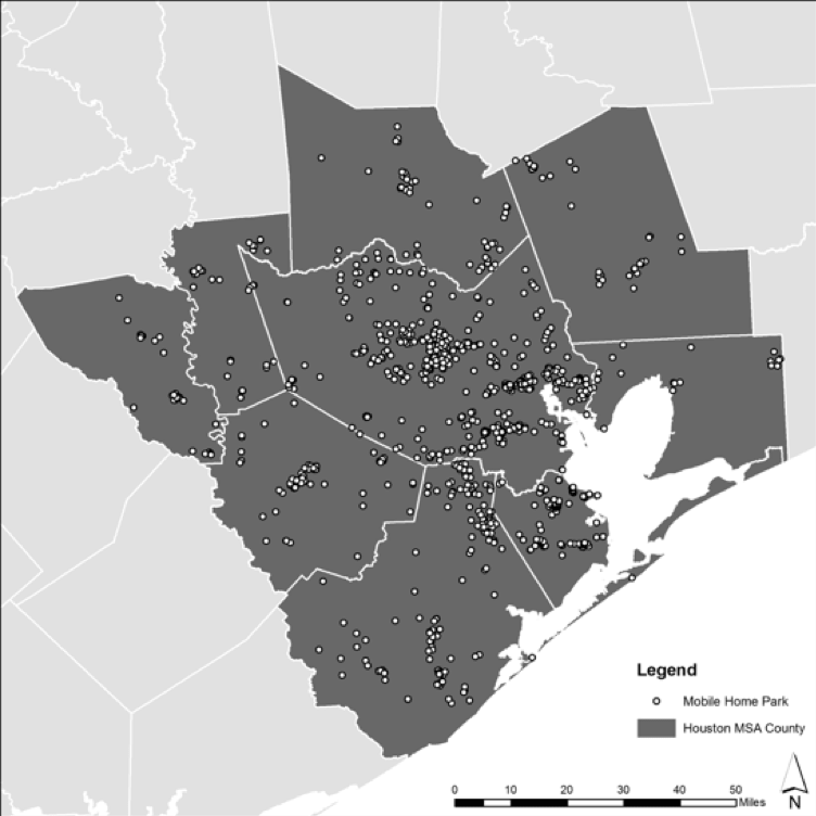
Map 1: Mobile home parks in the Houston MSA. Source: Land use data from each of the nine Houston MSA counties
To understand the severity of flooding across the MSA and assess the effect of flooding on mobile home parks, we acquired precipitation and flood modeling data from the Pacific Northwest National Laboratory (PNNL, managed by the U.S. Department of Energy Office of Science). Based on the five-day quantitative precipitation forecast (QPF) provided by the National Weather Service (NWS) between August 24 and August 29, 2017, local topography, and a single wide-area average infiltration rate, this data purports to show all areas in southeast Texas that experienced some degree of flooding as a result of Hurricane Harvey. The data is expressed in “dry time days,” referring to the number of anticipated days for floodwaters to recede entirely and for an area to return to a “dry state.” Starting from August 27, 2017, a higher number of dry time days indicates a longer amount of time for floodwaters to recede. For example, a measure of one dry time day indicates that floodwaters receded by August 28, while a measure of 30 dry time days suggests that floodwaters were present between August 27 and September 26 (or later). Using an overlay analysis of the mobile home park dataset and the dry time days dataset, we estimated that 432 of the 1,046 mobile home parks in the Houston MSA (41 percent) experienced some degree of flooding during and after Hurricane Harvey (Map 2).
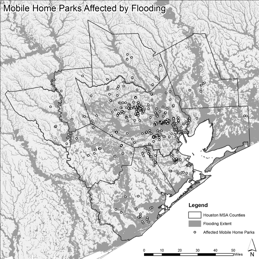
Map 2: Mobile home parks affected by flooding (estimate).
The graphs below show the distribution of the 432 affected mobile home parks across the 30-day dry time day period. This chart shows that the majority of mobile home parks which experienced flooding by August 27, 2017, (308 of 432, or 71 percent) returned to a “dry state” three days later (by August 30). These parks we considered “somewhat” or “likely” to have flooded. A significant portion of the affected mobile home parks (39 of 432, or 9 percent) are located in areas that took 30 days or more to return to a “dry state,” indicating severe flooding. These parks we considered “very likely” to have flooded.
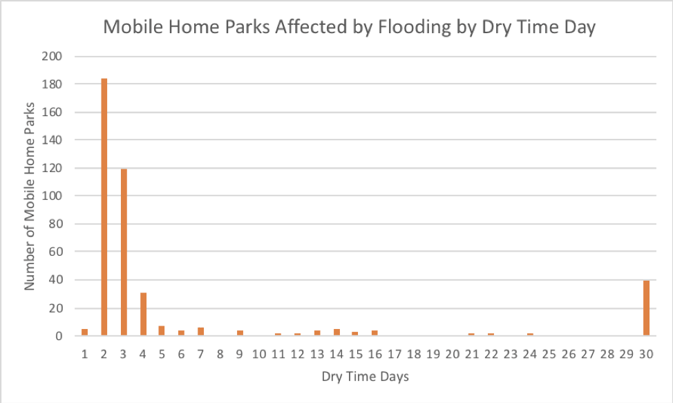
Figure 2: Mobile home parks affected by flooding by dry time day. Source: PNNL
Quick Response Grant Field Data Collection
With the support of the Quick Response Grant, our research team visited the Houston region in February 2018 to “ground truth” our geospatial methodology and preliminary findings about the location and flooding of mobile home parks, and conduct exploratory interviews about park recovery. We visited 25 mobile home parks in suburban and rural communities in Brazoria County, south of downtown Houston. We chose Brazoria County because it was likely to have parks in diverse spatial contexts, from dense urban neighborhoods to rural communities, and because it suffered moderate to significant damage during the storm. We visited 20 parks that our analysis had suggested were somewhat, likely, or very likely to have flooded, and 5 parks that were likely to have not flooded. In each park, we looked for signs of flood damage, like physical damage to mobile home units (see Figures 1 and 2), notices of inspection (see Figure 3), and new units that may have replaced flood damaged trailers (see Figure 4). We also spoke briefly (5-30 minutes) with individuals or groups of individuals in each park that were knowledgeable about the park’s experience during Hurricane Harvey.
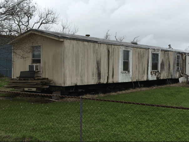
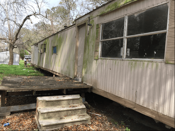
Figures 3 and 4: Evidence of flood damage on mobile homes.
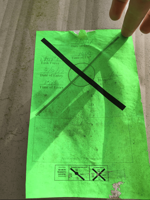
Figure 5: Notice of safety inspection on a mobile home.
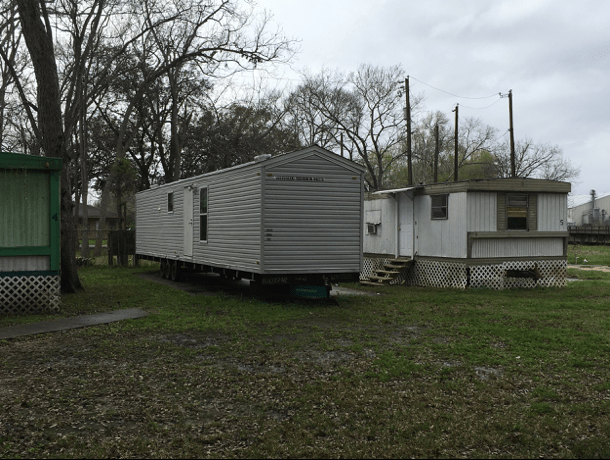
Figure 6: A replacement mobile home.
We also conducted four expert interviews on topics related to affordable housing and Hurricane Harvey. The interviewees were from Texas Housers, one of the largest affordable housing research and advocacy organizations in the state, the Kinder Institute at Rice University, and state and federal recovery officials staffing the Disaster Recovery Center for Brazoria County.
Preliminary Findings
Our field data collection led to important preliminary findings that will help inform our future research:
Park mapping methodology accurate, but incomplete: Our methodology for mapping the location of mobile home parks appears trustworthy, as all 25 addresses we visited were confirmed to be mobile home parks. However, during our visit, we also noted a number of mobile home parks that were not in our dataset, meaning that our methodology is not capturing all mobile home parks in the Houston MSA. Future research will be needed to understand the scope of the undercounting and whether there are any systemic reasons why some mobile home parks are not identified as such in land record data. Moving forward, we will augment our methodology to use systematic visual identification via satellite imagery and may employ geographic information system (GIS) methods of automatic object identification (see below).
Flooding assessment methodology not reliable: Our field data collection also showed that our methodology for estimating park exposure to floods is not reliable. While some of the parks we expected to have received damage were flooded, more than half showed no visual signs of flooding, and residents reported no significant damage to mobile homes. Similarly, one of the parks we visited that we did not expect to have flooded had suffered significant damage. This finding points to limitations of flood modeling data using “dry times.” A revised methodology will employ alternate flood models for the Houston MSA (see below).
Mobile home parks excluded from housing conversation: Through interviews and reviews of local and state recovery documents, we have found that mobile home parks are a crucial source of affordable housing in Houston, but have been largely excluded from conversations about housing and post-Harvey recovery. In our conversations with park residents, and with housing experts, we found that mobile home parks were largely absent from the public conversation about housing damage, and not offered any specific or specialized recovery programs that recognize the unique conditions and needs in MHPs. Future research will document specific processes and mechanisms that contribute to the exclusion of MHPs from local housing recovery planning.
Damage assessment process for mobile homes likely an important issue: In numerous conversations with park residents, and in our expert interviews, the topic of damage assessment was raised as an important variable impacting recovery. From the perspective of mobile home residents, the Federal Emergency Management Agency (FEMA) damage assessment often led to payment amounts that were too little to effectively repair mobile homes. State and federal recovery officials argued that homeowners sometimes have an unreasonable expectation of recovery programs, but acknowledged that there are significant challenges to properly inspecting damage in mobile homes. How mobile home parks were inspected post-Harvey, and the amounts that homeowners were able to receive, will be key variables for understanding short and long-term recovery.
Individual assistance may have overlooked some mobile home parks: In conversations with residents at a diverse range of parks, we found conflicting evidence about the “saturation” of individual assistance grants to eligible households. The FEMA individual assistance (IA) program requires that households apply for assistance, so resident knowledge and willingness to participate in the program are crucial variables that determine program effectiveness. In some parks, residents described a well-advertised IA process that was aided by local social networks and social media postings. In other parks, residents claimed they had no knowledge of the IA program and were not notified that they might be eligible. Both narratives are likely true, and will require us to determine the types of factors that might have led to uneven advertisement and enrollment. For example, we noted that a number of parks we visited were hidden from view from the street, located on unimproved (dirt or gravel) roads, and lacked clear signage. In those instances, it is reasonable to assume that information canvassers from FEMA may not have visited the parks. Similarly, many parks are primarily Spanish-speaking, and willingness to participate in the IA application process might have been lower if there were concerns about immigration status among householders. Given that IA monies are a centrally important recovery resource, documenting the variation in program participation across parks will be central to understanding disparate recovery trajectories.
Implications for Future Research
These findings have significant implications for our research agenda moving forward. First, in terms of the mobile home park population, our preliminary analysis shows that mobile home parks are a substantial source of affordable housing and are common throughout the Houston metropolitan area. The 1,046 parks we mapped likely contain tens of thousands of units of housing. An important next step will be to manually count the number of pre- and post-Harvey mobile home units in each park, which will provide a clearer and more robust population frame for future sampling. Second, as described above, a substantial number of parks seem to be omitted from our database, which relies on the land classification of parcels. We will need to investigate these errors and determine why parks are being excluded, and develop a methodology for locating them to include in our database. For example, if there is a routine land use classification attached to omitted parks, we could reanalyze our tax parcel data to include it. We might also use automatic object identification and classification procedures in GIS to identify likely mobile home parks, and visually confirm them. Third, our method for estimating the spatial impacts of Harvey flooding is clearly insufficient, and will need to be revised. Several possibilities exist for alternate flooding models, such as using IA grant data to identify neighborhoods where the impacts of flooding were more severe. These approaches also have their shortcomings, however. FEMA IA data, for example, is based on households who request assistance. We know from past research that the registration requirements for federal recovery programs are a barrier for certain households to receive assistance, especially those with concerns over their immigration status or the immigration status of family or neighbors. Thus, future flood models will likely be based on multiple data sources. Finally, our field visits to 25 parks confirmed that there is a great diversity of mobile home park characteristics, such as park sizes, dates of construction, ownership structures, infrastructure quality, and spatial arrangements, in a variety of development and governmental contexts that will likely be important for understanding exposure to flooding and recovery trajectories. To understand damage and recovery across such a varied population of parks will require that we develop detailed case studies, appropriately sampled from the total MHP population and followed over time. If we receive significant support for the research project, our approach will expand to include quantitative modeling of the above park level characteristics alongside a larger sample of case study parks to understand housing recovery in the context of internal and external pressures on the MHP housing stock.
References
-
Chaney, Philip L. and Greg S. Weaver. “The Vulnerability of Mobile Home Residents in Tornado Disasters: The 2008 Super Tuesday Tornado in Macon County, Tennessee.” Weather, Climate and Society 2, no. 3 (2010): 190–199. ↩
-
Kellner, Olivia, and Dev Niyogi. “Land Surface Heterogeneity Signature in Tornado Climatology? An Illustrative Analysis Over Indiana, 1950-2012.” Earth Interactions 18 (2014). ↩
-
Pierce, Gregory, C.J. Gabbe, and Silvia R. Gonzalez. “Improperly-Zoned, Spatially-Marginalized, and Poorly Served? An Analysis of Mobile Home Parks in Los Angeles County.” Land Use Policy 76 (2018): 178–185. ↩
-
Rumbach, Andrew, Carrie Makarewicz, and Jeremy Nemeth. “The Importance of Place in Early Disaster Recovery: A Case Study of the 2013 Colorado Floods.” Journal of Environmental Planning and Management 59, no. 11 (2016): 2045–2063. ↩
-
Rumbach, Andrew, and Carrie Makarewicz. “Affordable Housing and Disaster Recovery: A Case Study of the 2013 Colorado Floods.” In Coming Home After Disaster: Multiple Dimensions of Housing Recovery, edited by A. and A.M. Esnard Sapat. New York: CRC Press, 2016. ↩
-
Sullivan, Esther. “Displaced in Place: Manufactured Housing, Mass Eviction, and the Paradox of State Intervention.” American Sociological Review 82, no. 2 (2017a): 243–269. ↩
-
Sullivan, Esther. “Moving Out: Mapping Mobile Home Park Closures to Analyze Spatial Patterns of Low-Income Residential Displacement.” City & Community 16, no. 3 (2017b): 304–329. ↩
Rumbach, A. & Sullivan, E. (2018). Hurricane Harvey, Mobile Home Parks, and Flood Risk (Natural Hazards Center Quick Response Research Report Series, Report 283). Natural Hazards Center, University of Colorado Boulder. https://hazards.colorado.edu/quick-response-report/hurricane-harvey-mobile-home-parks-and-flood-risk