Collective Action in Communities Exposed to Recurring Hazards
The Camp Fire, Butte County, California, November 8, 2018
Publication Date: 2019
Abstract
The Camp Fire, which began on November 8, 2018, provides an instructive case study of the size, scale, and costs of wildfire risk in California. This report summarizes findings from a Quick Response research study conducted with support from the National Science Foundation, administered through the Natural Hazards Center at the University of Colorado Boulder. Findings are based on six field trips to the fire-damaged region to interview decision-makers from federal, state, county, city, and town organizations who were actively engaged in response and recovery operations related to the fire. The research team also reviewed news reports, agency documents, and official emergency plans, and documented visual observations of the damaged area.
The report characterizes wildfire risk to the town of Paradise and Butte County, and reviews organizational plans and preparedness actions taken by responsible organizations prior to the wildfire. It presents a preliminary timeline of the event, documenting the severity of the actual event against plans and resources available, and assesses the dynamic conditions and processes that shaped performance during the event. The report also presents a model of traffic simulation to explore alternative strategies for managing evacuation on a regional scale and discusses strategies for mitigating wildfire risk in a changing ecological, economic, and social climate.
Introduction
California faces a continuing crisis: As environmental conditions increase the frequency and severity of wildfires in the state and populations move into areas prone to wildfires, social and economic losses escalate exponentially (NBC News, 20181). California now experiences wildfire events throughout the year, and the risk is also increasing nationally, particularly in Washington, Oregon, Arizona, and Colorado in the West and Florida and Alabama in the Southeast. The economic cost of the 2017 California wildfires was estimated at $18 billion, with ensuing social costs of interrupted schooling, housing, transportation, business operations adding to the trauma and time needed for recovery (Pierre-Louis, 20182). The immediate costs of the 2018 wildfires in California were estimated to be nearly $25 billion (Governor Newsom’s Strike Force, 20193). Such escalating costs are unsustainable. Determining new models for how communities can identify and reduce the risk of wildfires is essential for the millions of residents—men, women, and children—who live at the urban/wildland interface. Building the capacity for collective action to reduce this massively complex problem is a task that only the whole region can collectively solve.
The Camp Fire, which began on November 8, 2018, provides an instructive case study of the size, scale, and costs of wildfire risk in California. This report summarizes the findings from a Quick Response research study of the Camp Fire, conducted with support from the National Science Foundation, administered through the Natural Hazards Center at the University of Colorado Boulder. The interdisciplinary research team from the University of California, Berkeley, included three faculty researchers and four graduate students in engineering, public policy, architecture, and computational modeling. The research team collectively made six field trips to the fire-damaged region to interview decision-makers from federal, state, county, city, and town organizations who were actively engaged in response and recovery operations related to the fire. The research team also reviewed news reports, agency documents, and official emergency plans, and documented visual observations of the damaged area.
This report aims to:
- Characterize the wildfire risk to the town of Paradise and Butte County and review the organizational plans and preparedness actions taken by the responsible organizations prior to the event;
- Present a preliminary timeline of the event, documenting the severity of the actual event against available plans and resources;
- Assess the dynamic conditions and processes that shaped response performance during the event;
- Present a traffic simulation model as an example of exploratory research to design alternative strategies for managing evacuation on a regional scale during future wildfire or hazardous events; and
- Discuss possible strategies for mitigating wildfire risk in a changing ecological, economic, and social climate.
2018 Camp Fire: Context and Measures Taken to Reduce Wildfire Risk
The ferocity of the Camp Fire can only be understood in the context of the region’s physical geography, terrain, and climate. The town of Paradise is aptly named, as it is nestled in a pine forest and bounded by a canyon, with the Sierra Nevada mountains rising behind the town and a view of the Sacramento Valley stretching below. Yet, this idyllic location is uniquely susceptible to wildfire, as summers get longer and hotter, parched pine needles fall from the trees, and winds blow fiercely through the Jarbo Gap, the canyon that separates the ridge on which the town is built and the mountains behind. Any ignition can be deadly.
Both officials and residents of Paradise are well aware of the wildfire risk. Cal Fire, California’s state agency responsible for fire detection, prevention, and preparedness, had organized training exercises based on wildfire hazards in the region for twenty years. Butte County had experienced wildfire events previously, most recently in 2008, and county and town officials had used these events to review the risk and develop detailed plans for preparedness and evacuation. Paradise had developed a detailed plan for evacuation of residents, identifying 14 zones in the town and specifying the order in which residents would evacuate, to allow time for the 26,682 residents to leave safely through the four designated evaluation routes. All residents were counseled to know their zone and the order of zones for evacuation, if necessary. Pamphlets were distributed to households to inform them of the “Ready, Set, Go!” Program, which is managed by the International Association of Fire Chiefs to improve dialogue between fire departments and the residents they serve (International Association of Fire Chiefs, 20194). The Paradise town council scheduled town meetings to engage residents in developing both individual and neighborhood evacuation strategies. Emergency services personnel conducted simulated evacuation exercises using the contraflow strategy to allow residents to practice driving on all four lanes of the highway out of town. Yet, an unusual confluence of events on November 8, 2018, overwhelmed the plans and protocols designed to protect the region and enable residents to manage the wildfire risk wildfire.
The network of formal plans and policies for wildfire risk reduction developed at the state, county, and local levels are evidence of the investment of time, thought, and effort that had been made to counter wildfire risk in California. Three major types of planning activities undergirded the response operations for this extreme event. First, the set of federal frameworks for emergency planning developed by the Federal Emergency Management Agency (FEMA) outline a common set of goals and emergency support functions for all fifty states in the United States. These frameworks represent a formal set of organized plans that structure emergency support functions for all types of hazards across all jurisdictional levels. The five frameworks address prevention, protection, mitigation, response, and recovery (Federal Emergency Management Agency, 20195). Consistent with the federal frameworks, each jurisdiction develops its own emergency plan to reflect the specific hazards and resources that characterize its hazardscape (Cutter, 20166).
California, given its vulnerability to a range of natural hazards, including earthquakes, wildfire, floods, landslides, and drought, has developed the Standardized Emergency Management System (SEMS) to ensure a common set of terms, functions, and operations procedures across the 58 counties and their component municipalities (California Emergency Management Agency, 20097). This inter-jurisdictional network of emergency plans provides a common framework for operations and training in emergency events that exceed the resources and capacity of a single jurisdiction and require collaboration and shared response operations across multiple jurisdictions. Similarly, Butte County has developed its county-wide plan that outlines procedures and resources available to monitor and manage risk within its geographic and environmental boundaries. The town of Paradise, within Butte County, developed an emergency plan with a focus on wildfire, recognizing the geological, meteorological, and climate-related risks to the community (Cal Fire, 20188).
Planning activities have also focused on developing the communications infrastructure, protocols, and procedures needed to detect and report incidents and to mobilize timely response operations to bring incidents under control as quickly and efficiently as possible. Communication is central to achieving effective coordination in rapidly escalating emergencies and is dependent upon the technical infrastructure that enables it. Although California has a statewide 911 system, in which emergency calls can be made by telephone from any location in the state, calls are routed through a voice-over-internet-protocol (VoIP) system to a public safety access point (PSAP) closest to the site of the reported incident. There are 437 PSAPs statewide in California, which provide a comprehensive network of local access points. Calls received at the PSAPs are then transmitted over commercial telephone services or agency radio channels to local jurisdictions and agencies to mobilize response operations. In extreme events, commercial telephone services are vulnerable to damage or disruption from hazards, as cell towers are damaged or transmission lines downed. Agency radio systems have crossover channels between some but not all agencies. Even so, in an intensely developing event, access to a shared radio channel (e.g., between police and fire agencies) can become difficult as many personnel attempt to communicate messages at once. Alternatively, if a critical agency does not share a radio channel and commercial phone systems are down, it becomes extremely difficult to coordinate actions under urgent conditions. Organizational coordination is constrained by the technical infrastructure that enables it.
A third set of activities central to building the capacity of a community to respond collectively to an extreme event is the informal development of a sense of shared community and informed commitment to reduce risk. These activities are often set by the example of local leadership through articulation of a clear vision of risk for the whole community and the development of a set of actions that can be taken by all residents to reduce that risk. For example, the Paradise town council held town meetings to engage residents in the process of developing and reviewing the evacuation plans for the town. The Butte County Sheriff’s Office organized a “Truck or Treat” event for Halloween in 2018 and invited community residents to bring their children, dressed in costume, to visit the office, meet the personnel, and see the equipment and vehicles that help keep the community safe. These informal interactions between public agencies and community residents in nonemergency times forge a bond of trust among residents and between residents and public officials that is crucial in enabling community residents to act collectively in uncertain situations. This bond rests upon an awareness of shared risk and a clear understanding of credible actions that can be taken to reduce that risk for the whole community. A list of organizational partners and other organizations that contributed to response operations in the Camp Fire is provided in Appendix A. A list of field activities undertaken for this study, including interviews with organizational personnel is included in Appendix B.
Preliminary Timeline and Critical Decision Points in Response Operations
An abbreviated timeline of critical points of decision during the Camp Fire is shown in Figure 1. The times and events listed were cited in interviews by participants in the events but are not taken from official records. We requested the 209 incident status reports for the Camp Fire that were maintained by Cal Fire but were informed that since the case is still under investigation, those reports would not be available until the investigation was closed. When these incident reports are available, we plan to conduct a more systematic analysis of the time, direction, and interaction among agencies documented by inter-agency communications, and model possible alternative strategies under different conditions of time, access, and types of equipment.
Figure 1. Timeline of critical events showing progression of the Camp Fire, Butte County, November 8, 2019
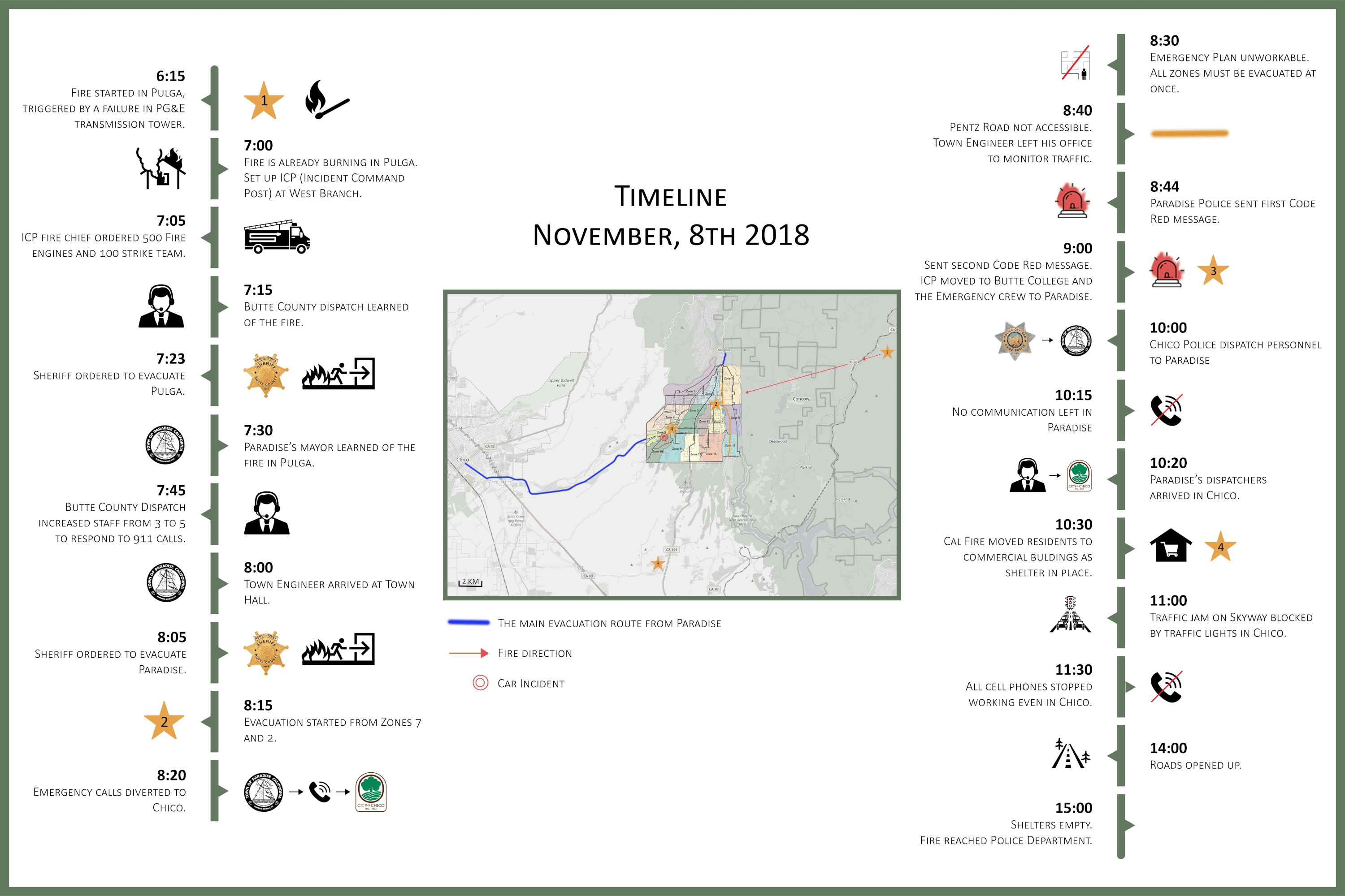
The rapid progression of events that characterized the Camp Fire in Butte County, California, represented an extraordinary alignment of physical, meteorological, and ecological conditions that overwhelmed the capacity of the network of organizations that had anticipated and planned for an extreme wildfire event. As the timeline in Figure 1 shows, the fire, ignited by sparks from a faulty transmission tower managed by Pacific Gas & Electric Company, the utility company that provides electrical power to Northern California, started spot fires in the forested area near Pulga, an unincorporated community on the west side of the Feather River Canyon (Serna & Luna, 20199). Emergency crews initially set up an incident command post at West Branch near Pulga to contain the fire, but hot, dry winds picked up embers, and within an hour, carried them across the canyon to threaten Paradise, approximately 20 miles away. In Paradise, ecological conditions, including 237 days without rain and a beetle infestation in its pine forest, had left the town dangerously vulnerable to wildfire, with dead timber and dry pine needles providing ready fuel for the flames. These conditions proved far more complex and dynamic than anticipated by the deliberate planning process.
Wildfire is a known risk in Butte County, and residents of the region had experienced a major wildfire in 2008. The question is how to reduce that risk under changing conditions. The local fire department in Paradise, Unit 35, Butte County, operates within the larger network of Cal Fire, the statewide fire protection agency, and developed a detailed plan for evacuation of residents by zone in case of fire. The Paradise town council held town meetings to introduce the plan to town residents and engage them in evacuation exercises, given the limited number of routes out of town. The residents had practiced contraflow, or driving in one direction out of town. Thus, Paradise had earned a reputation as a “fire-safe community.”
Figure 2. Map of Paradise showing evacuation zones and routes out of town.
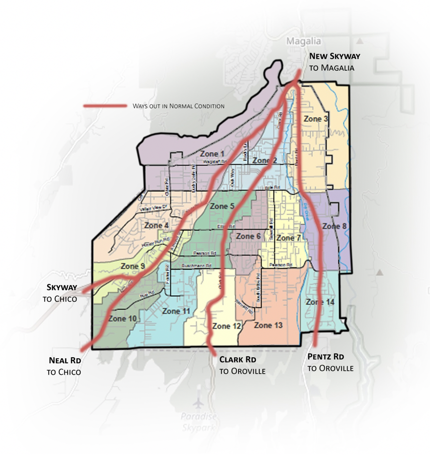
Figure 2 shows the map of Paradise with the 14 designated evacuation zones and four routes out of town. Zones 2 and 7 were designated to evacuate first, using Pentz Road to Oroville. Pentz Road, closest to Feather River Canyon, was quickly engulfed in flames and rendered inaccessible. As the fire spread, Clark Road became inaccessible, leaving only two viable routes out of town. All efforts by emergency personnel and residents focused on evacuation. As the fire advanced through Paradise, the residents recognized the extreme risk and moved quickly to rescue themselves and their neighbors, acting collectively to help each other. Although 85 lives were lost in this deadly fire, 99 percent of the population of Paradise evacuated safely in a remarkable display of self-organizing collective action for the benefit of the whole community.
The Dynamics of Wildfire
A central question is how did a spot fire ignited by a relatively modest electrical spark in wildlands escalate so quickly into a catastrophic fire that devastated Paradise and burned 153,336 acres of wildlands, communities, and forest in Butte County? What dynamic interactions among natural, physical, ecological, technical, and human conditions triggered and amplified this event? What innovations or insights gained from this event could reduce risk in future scenarios as human communities move increasingly into wildland areas? The four areas described below warrant special attention, although surely there are others.
Complexity and Dynamics at the Socio/Technical/Wildlands Interface
The rapid series of events illustrated by the timeline shown in Figure 1 demonstrate the complex interactions among the terrain, winds, temperature, and forest that created a natural environment highly susceptible to fire in Butte County; A flawed technical system with the capacity to ignite added to the fragile natural environment, increasing the risk. In addition, resources needed to mobilize over large distances in a rural region, and the time required for travel limited immediate action. With every minute of delay, the ignition escalated until it reached a threshold point defying human intervention. At that point, the fire then fed itself and entered a transition phase that consumed any natural, technical, or human phenomena in its path.
This pattern of ignition and escalation of wildfire in social and human environments is not new. What is new is the capacity to bring together a range of knowledge, skills, technologies, and disciplines to create a shared base of knowledge for all involved organizations, jurisdictions, and actors. While planning for organizational and community response is essential, the complexity of this environment requires a deeper knowledge of the science underlying the hazard of wildfire, recognition of the interactive consequences of a changing environment, and adoption of innovative technologies to monitor and model changes in the underlying conditions that precipitate wildfire. Further, both evolving knowledge and technologies support an iterative process of review, reflection, and redesign for the organizational programs designed to engage residents at the wildland interface in adapting their actions to the changing environment.
Public agencies have the legal responsibility to lead this task, but they cannot do it alone. Actions taken in response to fire ignition build on the degree of preparedness, organizational capacity, technical infrastructure, knowledge, and training in place before the fire breaks out. Building resilience to wildfire requires the full commitment of all organizations and jurisdictions, business entities, community groups, and households to monitor the risk and adapt their actions accordingly. Understanding the depth and complexity of wildfire risk in a changing socio/technical/ecological environment is the first step toward managing this risk more effectively.
Communications
As the timeline in Figure 1 shows, communication among multiple agencies, jurisdictions, and communities at risk is fundamental to alerting communities to danger and mobilizing response operations rapidly. The basic communications infrastructure available to emergency personnel in California is effective for managing routine, daily emergencies. In urgent, catastrophic events such as in wildfire, when the technical infrastructure that supports the statewide 911 system is also under threat, the communications system, by definition, is vulnerable. Without communications, the capacity to mobilize coordinated inter-organizational, inter-jurisdictional response operations decreases. The loss of cell towers as the fire advanced in Paradise sharply reduced communications as town residents faced the most urgent tasks of evacuation. The planned rollover of 911 dispatch calls from Paradise to Chico to Butte County facilitated the region-wide communications process, but for residents reliant on cell phone access, the loss of communications at the most critical time left them dependent on their own resources, their immediate neighbors, and local personnel. Further, the volume of calls in such an event escalates tenfold beyond normal operations. For example, Butte County dispatch reported 2800 calls logged on November 8, 2018, by midnight; 1400 incidents were created in all call areas of the county. For the period, November 8–30, 2018, Butte County dispatch logged over 30,000 phone calls. One dispatcher had 563 calls in a 12-hour shift, or approximately 47 calls per hour. This volume of activity places extraordinary mental and emotional demands on the dispatchers who create a vital human connection between the changing dynamics of the fire and the callers seeking assistance.
Communications is fundamentally a sociotechnical process that enables humans to engage in informed, coordinated actions. In a catastrophic event such as the Camp Fire, the limitations of the technical infrastructure, hardware, and software that enable humans to exchange information over distance in a timely manner quickly become apparent under the stress of the actual event. The functionality of the communications system is a measure of performance for the overall response system. Yet, communications within the larger response system are composed of multiple points of interaction—hardware to software, software to human operator, human operator to sender and receiver. Each of these points comes under stress in an extreme event, and the capacity of the communications system to maintain its interdependent functions depends on workable connections among all points. If any one point fails, the communications system falters.
Extreme events become testing grounds for communications systems, and response operations in the Camp Fire provided a rigorous test. Cal Fire, the state fire protection agency, had primary responsibility for managing operations during the event but established a collaborative working relationship with relevant state agencies through the state operations center activated by the California Governor’s Office of Emergency Services. Other state agencies mobilized for response operations included the California Highway Patrol, California Department of Fish and Wildlife, California Department of Justice, California National Guard, and California Department of Health and Human Services. Cal Fire uses a radio system that has a common platform with law enforcement, and emergency medical services, agencies that serve as first responders during urgent events.
The possibility of cross-agency communication is critical in a fast-moving event, but it also has the disadvantage that in intense activity, if too many personnel try to use the system simultaneously, the resulting chatter blocks communication for anyone. In the Camp Fire, public agencies used any and all modes of communication to alert residents to danger: radio, cell phone, internet, and social media platforms such as Facebook and Twitter. The Paradise police department sent two CodeRED messages to all residents, alerting them to the fire and ordering a mandatory evacuation of the town. The national emergency alert systems—Wireless Emergency Alerts (WEA) and Integrated Public Alert and Warning System (IPAWS)—were not used, as both systems require internet access and broadband spectrum that were not available. Throughout Butte County, residents exchanged messages via social media to send and share updates on the changing situation when cell phones failed or radio systems were not available.
The mix of communications systems revealed breaks in the available networks that warrant review. Importantly, the California Highway Patrol does not share a common platform with Cal Fire or local law enforcement agencies, such as the Butte County Sheriff’s Office or Chico Police. This was a critical break in the process, as law enforcement agencies were managing the evacuation of Paradise and other small communities. Other breaks already noted included the collapse of cell phone communication in Paradise and parts of Chico and the transfer of 911 dispatch services from Paradise to Chico to Butte County.
Evacuation
As already noted, evacuation became the only strategy possible for Paradise and other small communities in Butte County, given the rapid escalation of the wildfire. Yet, the actual evacuation was constrained by the physical network of roads, the limited time available for residents to leave safely, and the number of people and vehicles that could move through the available routes. Evacuation is primarily the responsibility of law enforcement, and the local police departments of Paradise and Chico, as well as the Butte County Sheriff’s Office were actively engaged in initiating the process. In this event, the intensity of the fire demanded that all emergency personnel support evacuation, so fire and emergency medical personnel worked directly with police to assist local residents. Local residents also joined this effort. A newly elected town council member directed traffic at intersections; residents with extra space in their vehicles offered rides to neighbors who needed assistance. In one particularly critical situation, approximately 200–300 residents were stranded in Paradise unable to leave, with the fire advancing around them. Local fire personnel directed the group to the Walgreens pharmacy, recently built with fire-resistant construction, and ushered the whole group into the building to shelter in place. Outside, fire personnel circled the building with their engines to protect it. Inside the building, personnel took fire extinguishers off the shelves and used them to cool the building and protect the people inside. Such decisions were not written in any emergency plan but were made by quick-thinking first responders who recognized the risk, searched for available resources, and took prompt action to protect the residents of the town.
Self-Organization in the Community
Throughout the intense activities of this extreme event, there was a remarkable demonstration of the translation of cognition of risk into shared action for the benefit of the community. Emergency personnel demonstrated extraordinary courage in risking their own lives to protect residents of the community. Public personnel worked long hours under intensely demanding conditions to provide the best services possible. Local leaders set an example for informed, collaborative action to protect the community. Ordinary residents understood that message, and translated it into action in their own ways, helping one another, staying calm, and focusing on the primary goal: enabling the entire community to evacuate safely.
In many respects, this capacity for self-organization under threat is the goal of community resilience. In the case of Paradise and Butte County, several factors likely contributed to its development. The active planning processes that the Paradise, Butte County, and the State of California had undertaken prior to the fire likely contributed significantly to creating an informed understanding of the risk of wildfire in the community. Prior experience with wildfire in Butte County in 2008 and in adjacent counties likely led to residents’ increased awareness about the vulnerability of the region. The recent experience of evacuation from the threat of collapse of the Oroville Dam created a practice scenario for evacuation in extreme events for public personnel. This event was referenced several times by local law enforcement personnel as a learning experience regarding the complexity of interactions for multijurisdictional events and the coordination required to carry them out successfully. Active engagement by local leaders who understood the physical and technical characteristics of the region, and the limitations these characteristics imposed upon formal plans, reinforced a vision of responsible leadership that enabled personnel in the field to take timely, informed action based on direct observation of risk and the resources available.
The events documented in the Camp Fire demonstrate vividly that self-organization indeed occurred in Paradise and surrounding jurisdictions. The capacity to recognize risk and translate that cognition into collective action under existing conditions is the goal of a resilient community. It is also an area where research and modeling may offer possible strategies to assist communities in building that capacity. As part of this study, our research team developed a simulation of traffic patterns in the region as a means of exploring possible alternatives for evacuation in future events or in other communities that confront similar physical/ecological/meteorological risks.
Paradise Traffic Simulation
In an effort to understand the cascading effects of the Camp Fire, a countywide traffic simulation was performed to identify network vulnerabilities due to limitations in road capacity. The traffic simulation was carried out by modeling a set of vehicles to find each vehicle’s instantaneous fastest path to evacuate in a transportation network (Casey et al., 201710). The advantages of this study’s framework over many of the commercially available traffic simulation tools are the flexibility, performance, and evacuation-specific nature of the model. This temporo-spatial parallel computing tool can simulate regional-scale infrastructure networks with hundreds of thousands of links and millions of trips traveling near real time (McElwee et al., 201911).
The framework for the traffic simulation can be summed up in three main steps shown in Figure 3. In the first step (road network generation), the road network is generated based on data from the OpenStreetMap (OSM), an open source editable map of the world using volunteered geographic information. The entire Butte County road network can be downloaded from the OSM by querying the data within the bounding box [39.361, -122.431, 40.071, -120.981]. A graph object is then created based on the downloaded data for shortest path calculations in the later stage of the traffic simulation. The Butte County’s road network consists of 31,653 vertices (road intersections in graph terminology) and 75,559 edges (road links between two intersections). In addition to the vertices and edges, the OSM data also include attribute information, such as road types, lane counts, and speed limits for each road link. Capacity for each road can then be determined based on the attribute information. During step two (travel demand modeling), an hourly Origin Destination (OD) matrix is constructed for the assumed travel demand. Most commonly the travel demand is informed by the survey data, such as the California Household Travel Survey (CHTS) or the Census Transportation Planning Package (CTPP) (Vo et al., 201712). Due to the limited time for this case study, intracity and intercity travel demands are constructed simplistically according to the population in each municipality in Butte County. Table 1 lists the numbers of trips for the five largest municipalities (Chico, Paradise, Oroville, Oroville East, and Magalia) and the remainder of Butte County in the base scenario (i.e., no evacuation). These trips do not necessarily represent peak hour travel demand on a specific weekday; however, it is acceptable for testing regional scale modeling. Finally, in step three, shortest path calculations for each OD pair are completed using Dijkstra’s Algorithm. Volume-delay curves are incorporated in the simulation to model the impact of increased congestions and delays on road links given their fixed capacities. Further details of the model can be found from the open source GitHub repository for San Francisco.
Figure 3. Framework of the traffic simulation steps.

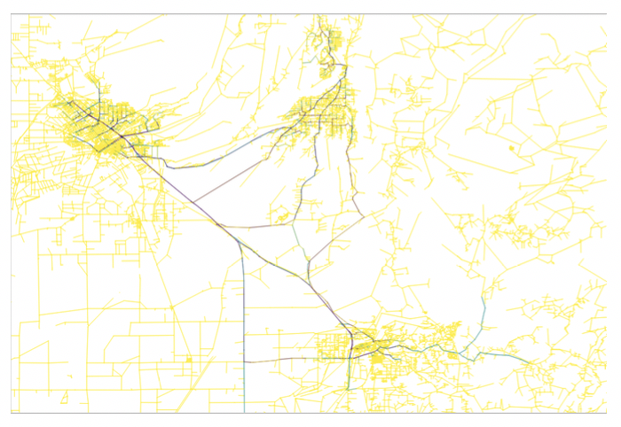
The traffic simulation experiment design consists of two scenarios. The first is the base scenario that represents the ordinary day peak hour traffic in the study area, i.e., no evacuation is considered. The second is the evacuation scenario, where all residents in the wildfire-affected municipalities (i.e., Paradise and Magalia) seek to evacuate to nearby towns (Chico, Oroville, and Oroville East). For the base scenario, 14,293 trips (10 percent of all vehicles in Butte County, disaggregation to municipalities shown in the last column in Table 1) are simulated to represent the peak hour traffic across Butte County. The maximum link volume is 1,592 vehicles over a one-hour time step. Figure 4(a) shows the resulting link volume or number of vehicles per link, with yellow links representing little to no traffic and darker green links representing high volume roads. For Paradise, Skyway Road, Neal Road, and Clark Road are identified as high-volume links connecting Paradise to Chico, Oroville, and the rest of Butte County.
In the evacuation scenario, additional traffic is considered due to the evacuation of Paradise and Magalia residents. The total travel demand of the evacuation scenario equals to 39,360 trips, including 28,151 vehicle trips representing the evacuation of 26,218 Paradise residents and 11,310 Magalia residents (75 percent car ownership is assumed), as well as 11,479 non-evacuation vehicle trips in other areas of the network. This represents an additional 25,337 vehicles traveling on the network compared to the base scenario. The 28,151 vehicles originating from Paradise and Magalia are split with 33.3 percent of trips to Oroville, and the remaining 66.7 percent of trips to Chico. The new maximum link volume is 19,631 vehicles, which represents an increase of more than six times the original maximum link volume under the base scenario. Figure 4(b) shows the link volume results for the Paradise evacuation scenario. One feature worth highlighting is the shift in traffic on previous high link roads like Neal Road to Skyway Road and the importance of Highways 99 and 149 in the evacuation.
These simulations are not intended to reenact exact conditions for peak hour travel or the Camp Fire specifically; however, they do aim to offer insights into potential bottlenecks and the impact of evacuation on surrounding communities. This underscores the importance of communication, especially across city boundaries. Future simulations will deploy dynamic models to evaluate the impact of contraflow on evacuation, as well as closing certain roads such as Pentz Road on affecting route choice and travel time on the day of evacuation. Additionally, modeling traffic buildup in Chico as a result of limited communication between Paradise and Chico on traffic congestion is also of interest. Implementing contraflow will offer insights on the minimum amount of time needed to evacuate Paradise under ideal conditions. Additionally, by overlaying fire intensity over time and the transportation network, it is possible to create a more realistic evacuation due to closed roads for the Camp Fire scenario. Overall, this exercise demonstrates the usefulness of simple, efficient, and flexible regional-scale traffic models tailored toward the understanding of various travel and evacuation scenarios.
Table 1. Population, assumed car ownership, and peak hour travel demand in Butte County Municipalities.
| Municipality | Population | Number of Vehicles** | Peak Hour Trips*** |
|---|---|---|---|
| Chico | 86,187 | 64,594 | 6,459 |
| Paradise | 26,218 | 19,668 | 1,966 |
| Oroville | 15,546 | 11,544 | 1,154 |
| Magalia | 11,310 | 8,483 | 848 |
| Oroville East | 8,280 | 6,199 | 619 |
| Rest of Butte County* | 43,336 | 32,473 | 3,247 |
| Total | 190,877 | 142,961 | 14,293 |
Figure 4a. Traffic volume distributions on the Butte County road network.

Figure 4b. Traffic volume distributions on the Butte County road network.
Renewal, Recovery, and Redesign
The traffic simulation offers an innovative approach to rethinking the design, construction, and management of traffic on a regional scale for Paradise. Other types of modeling may be productive to explore the most cost-effective means of rebuilding major infrastructure for the damaged community. There are serious reasons to question whether the fragile location of the town warrants rebuilding. The interdependent consequences of the wildfire are still unfolding. For example, seven months after the fire, there is still no piped water in Paradise. The intense heat of the fire damaged the fragile water infrastructure, as it warped the shallow PVC (polyvinyl chloride) piping that provided water to the town. Chosen for its flexibility, low cost, and resilience during seismic events, PVC piping had the opposite effect in wildfire. The PVC infrastructure, although buried underground, failed under the intense heat and leached chemicals into the water flowing through the pipes, contaminating the water, making it undrinkable, and thereby creating a secondary disaster. The cost of replacing the entire water infrastructure in Paradise has been estimated at $500 million - an extraordinary sum for a small community. Further, since the Paradise Irrigation District, which manages the town’s water system, is a private company, this cost is not eligible for federal reimbursement under the Stafford Act, which provides reimbursement for public infrastructure. Yet, rebuilding the water infrastructure is essential for all other aspects of recovery; homes, businesses, schools, and hospital services are all dependent upon ready access to water. The major question is how, when, and whether this process could be undertaken. For many residents of Paradise, the goal of rebuilding is not in question. Rather, exploring alternative strategies for reconstruction and finance through modeling and the creation of a wider range of access to resources and knowledge to support this effort becomes essential to the recovery process.
Conclusions and Recommendations
After reviewing the conditions, operations, and consequences that characterized this devastating event, five conclusions can be drawn about wildfire risk mitigation in other communities.
Changing wildfire risk requires adaptation in budget and capacity for collective action. The events of the Camp Fire detail the effects of a changing climate on the forest and grasslands of Butte County, with increasing risk of wildfire to the built environment and communities of the region. The need for increased monitoring of sensitive conditions, such as temperature, flammability of ground cover, and technical infrastructure for communications, water, and power all require public investment in the science and technology of managing wildfire risk. While public agencies have the legal responsibility to lead this effort, effective risk reduction will require the collaborative effort of private companies, research institutions, and nonprofit organizations. For states such as California, Arizona, Colorado, Oregon, and Washington, building collaborative models of risk reduction and dynamic operations that scale to changing exposure would be an invaluable investment in collective capacity to manage wildfire risk. Such effort will be expensive, but far less expensive than the billion-dollar costs that are likely to ensue if no action is taken.
Cognition to action—Informed residents of communities at risk will take responsible action to protect the community as a whole. A major resource for communities exposed to wildfire risk is an informed, responsible population. The actions taken by ordinary residents of Paradise and surrounding communities demonstrated unequivocally the capacity of local residents to take informed action to protect themselves, their neighbors, and their community facilities. Investment in programs of public education regarding wildfire risk, voluntary training, and access to multiple modes of communication enable community residents to build a degree of shared knowledge to recognize risk and act collectively to reduce risk for the community.
Learning from prior experience adds insight, understanding of complexity of large-scale events. Translating insights gained in other, relevant, large-scale, complex events for application to wildfire risk reduction increases the capacity of community organizations to act in coordinated efforts to reduce shared risk. Several interviewees in this study referenced the experience of the Oroville Dam evacuation as a constructive rehearsal for the coordination needed in a large-scale evacuation effort as required for Paradise and surrounding communities.
The intersection of science, technology, and human organizations creates a new, interdisciplinary science for managing wildfire. The rapidly changing, dynamic conditions that propelled the Camp Fire to its full, destructive impact in Butte County in November 2018 demonstrated decisively that no single discipline or organization could anticipate or manage to contain such a wildfire alone. It was the intersection of drought conditions, high winds, topography, and a faulty technical system that drove the fire, but these conditions were accelerated by a limited regional road network, limited equipment and trained personnel, and repeated disruptions in communications that inhibited coordination among organizations and people. To overcome these constraints, it is essential to reconsider the hazard of wildfire as generating a complex system of interacting systems that can learn and adapt to rapidly changing risk conditions.
Innovative approaches, new technologies, organizational designs, and science are central to improving the management the known risk of wildfire. This study demonstrated that a detailed command of the science underlying forest and grasslands management, well-designed sensors to detect change in ecological conditions, systematic data collection and analysis of both technical and organizational capacity, regular monitoring of changing conditions, and innovative modeling are essential to anticipate potential strategies for managing the known risk of wildfire that generates unknown consequences for communities at risk. Building the capacity to anticipate and reduce the cost of wildfire to urban communities will require steady, consistent, leadership and effort in confronting markedly changing firescapes.
To a significant extent, this process has already started in California. Governor Newsom’s proposed plan for public investment in wildfire risk reduction and planning (California Governor’s Office, 2019) addresses this need directly. Engaging the scientific and technical resources of the 10 campuses of the University of California would be a beginning step in building the knowledge base for a statewide map of wildfire risk and resources. However, such a process would require continuing research, community engagement, and collective action across the state—a bold but important step to reduce wildfire risk.
Acknowledgements. This study has been conducted with support from the Quick Response Program funding from the National Science Foundation, administered by the Natural Hazards Center at University of Colorado Boulder. We acknowledge, with thanks and appreciation, the Natural Hazards Center staff for their facilitation of this study. We give further warm thanks and appreciation to the public officials and staff from the following organizations who gave their time and shared their experience with us: Cal Fire; California Office of Emergency Services; Unit 35 fire department, police department, public works department, and the Paradise mayor; the Butte County 911 dispatch office, sheriff’s office, and fire department; the Chico police department, Federal Emergency Management Agency Individual Assistance Program, and the Small Business Administration. These officials are not named to protect their confidentiality, but we are grateful for their thoughtful insights into the very dynamic and complex problem of wildfire risk reduction.
Appendices
Download Appendix A
Download Appendix B
References
-
NBC News (2018). California wildfires costs soar past last year’s records. NBC. Retrieved June 12, 2019 from https://www.nbcnews.com/news/us-news/california-wildfires-costs-soar-past-last-year-s-records-n946856 ↩
-
Pierre-Louis, K. (2018). These Billion-Dollar Natural Disasters Set a Record in 2017. The New York Times. Retrieved June 12, 2019 from https://www.nytimes.com/2018/01/08/climate/2017-weather-disasters.html ↩
-
Governor Newsom’s Strike Force. (2019). Wildfires and Climate Change: California’s Energy Future. Retrieved June 12, 2019 from https://www.gov.ca.gov/wp-content/uploads/2019/04/Wildfires-and-Climate-Change-California’s-Energy-Future.pdf ↩
-
International Association of Fire Chiefs (2019). Ready, Set, Go! Retrieved June 12, 2019 from https://www.wildlandfirersg.org ↩
-
Federal Emergency Management Agency. (2019). National Planning Frameworks. Retrieved June 12, 2019 from https://www.fema.gov/national-planning-frameworks ↩
-
Cutter, S. (2016). The changing context of hazard extremes: Events, impacts, and consequences. Journal of Extreme Events, 3(2). ↩
-
California Emergency Management Agency. (2009). Standardized Emergency Management System Guidelines. Retrieved June 12, 2019 from https://www.caloes.ca.gov/PlanningPreparednessSite/Documents/12%20SEMS%20Guidelines%20Complete.pdf ↩
-
Cal Fire. (2018). Evacuation Plan, Town of Paradise. Butte County Fire Department, Unit 35, Paradise, CA. ↩
-
Serna, J. & Luna, T. (2019). PG&E power lines caused California’s deadliest fire, investigators conclude. Los Angeles Times. Retrieved June 12, 2019 from https://www.latimes.com/local/lanow/la-me-paradise-camp-fire-cal-fire-20190515-story.html ↩
-
Casey, G., Soga, K., Silva, E., Guthrie, P., & Kumar, K. (2017). A Scalable Agent Based Multi-modal Modeling Framework Using Real-Time Big-Data Sources for Cities. Transportation Research Board, 17-05941. ↩
-
McElwee, M., Zhao, B., & Soga, K. (2019). Real-time Analysis of City Scale Transportation Networks in New Orleans Metropolitan Area using an Agent Based Model Approach. MATEC Web of Conferences, 271. ↩
-
Vo, T., Lee, S., Wen, F., & Choi, S. (2017). The CTPP Workplace Data for Transportation Planning: A Systematic Review. Applying Census Data for Transportation Conference, 38. ↩
Comfort, L., Soga, K., Stacey, M., McElwee, M., Ecosse, C., Dressler, J., & Zhao, B. (2019). Collective Action in Communities Exposed to Recurring Hazards: The Camp Fire, Butte County, California, November 8, 2018. Natural Hazards Center Quick Response Research Report Series, 300. Boulder, CO: Natural Hazards Center, University of Colorado Boulder. Available at: https://hazards.colorado.edu/quick-response-report/collective-action-in-communities-exposed-to-recurring-hazards